- (Public Value) UCANR: Developing an inclusive and equitable society
- Author: Andrew J Lyons
- Author: Elizabeth Moon
- Contributor: Benjamin Satzman
A copy of this blog post can also be found on the Together@Work blog.
The Summit was held immediately before the 2023 FALCON (First Americans Land-Grant Consortium) Conference, another great conference which brings together hundreds of administrators, faculty, extension educators, researchers and students who work on land grant programs at TCUs and share program successes. Both meetings were amazing. While FALCON has been around for 19 years, this was only the second national meeting of the Land-Grant Partners consortium, and it was our first time at either event.
Three Generations of Land Grant Institutions
We felt in good company being with so many people working in land grant institutions all over the country. But seriously, what's with all the dates?
What all land grants have in common is a mission to support communities, agriculture, and natural resources through research and extension. However it was immediately apparent that most of the presentations, and even the conferences themselves, were structured around the three groups of land grant institutions which have become known by the year that federal legislation provided the initial funding: 1862, 1890, and 1994.
The 1862s are land grant universities that were established by the 1862 Morrill Act. This act gave ‘public lands' to every state, most of which was sold to create endowments for universities with programs in agriculture and engineering. Today, these are mostly the big state schools, like the University of California or Penn State, where Cooperative Extension programs are run from. The 1890s are historically Black Colleges and Universities, which Congress had to establish through separate legislation because the 1862 schools discriminated against people of color. Finally, more than a hundred years later, Congress finally provided funding in 1994 to support Tribal Colleges and Universities, collectively known as the 1994s or TCUs.
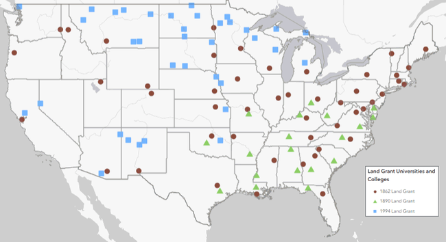
Click on the map to go to an interactive web map of the 1862, 1890, and 1994 land grant institutions
Source: USDA
Why all the fuss about the three generations of land grant institutions? Well, the sad reality is that although 1862s, 1890s, and 1994s all have similar missions, there are enormous gaps in how much funding they receive from federal and state sources. Not surprisingly, this results in unequal levels of resources for research and extension, and ultimately fewer programs for Native Americans and other people of color. This is precisely the nut the LGP and FALCON alliances are trying to crack.
Land-Grant Partners Summit
Most of the attendees at the LGP Summit were from 1862 institutions, with a handful of TCUs, federal agencies, and federally funded programs. Many 1862s are trying to do a better job serving Native Americans. This is in line with their mission to serve the entire public, and in recognition that there has been a huge gap for generations. Since 2020, the call for 1862s to try harder has grown louder, informed by research detailing how they got their start by selling millions of acres of stolen Indian land (Lee and Ahtone, 2020), and widespread national interest in dismantling structural inequality.
Everyone attending the LGP Summit knew this history, and although it needs to be told to a lot more people the focus of the Summit was looking forward. It was exciting to be with so many kindred spirits, to hear what other 1862s are doing, and think about how we can be more effective working together than individually. Some of the leaders in the movement include The Ohio State, which has started a program to reach tribes that were forcibly removed from Ohio, and South Dakota State University, which has diverted funding from its Morrill Act lands to support Native American students and collaborations with Tribal Colleges.
UC in the House
Although the University of California is not at the head of the pack when it comes to spearheading reconciliation and collaboration with Tribes, the ball is definitely rolling. It was wonderful to connect with new and old UC colleagues from UC Berkeley, UC Davis, and UC ANR, to hear what everyone is working on, and think about how we can work together more effectively. There are no shortages of ideas, and many faculty, students, and programs across UC are already doing amazing work to foster understanding and provide support for Native American students and other underserved populations.
However the goal will not be reached through celebrating the work of a few individuals. Rather, we need to shift UC as an institution - its policies, priorities, governance, incentive structures, resource allocation, and culture - so that the hard but rewarding work of healing and learning from Tribes is not the exception but the norm.
Making Spaces for Native Voices
A cross-cutting theme expressed in many sessions was the importance of including Native Americans as co-equal partners in designing and developing university programs and policies. Without Native voices at the table, and in meaningful leadership roles, we run the risk of planning programs with the same paternalistic processes that are well intentioned but ultimately fail to produce results. This is hard work, particularly within a university setting where administrators and academics are used to thinking a certain way, and doing things a certain way. But by learning from others, working together, and listening to those our institution owes a debt to, we can become a better university.
Sponsors and Collaborators of the 2023 Land-Grant Partners Summit




- Author: Andy Lyons
- Contributor: Suzanne Morikawa
Access to fast internet isn't just a luxury anymore. In our modern age, broadband is a necessity to take advantage of all kinds of basic services, from education, to banking, civic engagement, navigation, and even health care. Most broadband in the USA is provided by Internet Service Providers companies (ISPs), and while we're getting closer to universal coverage there is still a ways to go!
Broadband Mapping
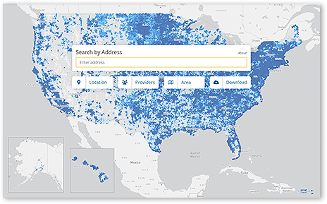
California was an early pioneer in broadband mapping, to show exactly where broadband is available and where it isn't. For the past 10 years, the Federal Communication Commission (FCC) has been collecting broadband data from ISPs for the entire country, and putting it on a national map. Actually there are two maps - one for fixed internet access points (i.e., homes and businesses), and one for mobile broadband. The latest version of the national broadband map was released in late November, and the FCC is now inviting the public to submit feedback through January 13, 2023.
Although ISPs are the primary sources of data, the FCC encourages everyone to check out the map. If the reported availability and speeds don't seem to tally with your experiences, they've also made it easy to submit feedback, known as ‘challenges'. And indeed thousands of citizens have been doing exactly this.
What does this have to do with me?
Exploring the National Broadband Map can be fun and is definitely educational - especially this year where the level of granularity is higher than ever. You can see which ISPs are serving your area, and what kind of connection speeds they claim.
But the map isn't simply for public information. The map with all the feedback submitted is also being used to identify where internet infrastructure investments are needed most to achieve the ultimate goal of universal access. And if you've been following the news recently, there's a lot of funding coming out of Washington and Sacramento right now to improve digital infrastructure.
Aside from helping steer resources where they're needed most, if you decide to contribute data to the national broadband map, you'll be joining one of the largest citizen science projects in the country. Thousands of residents just like yourself have used the mobile app and other tools provided by FCC to check their actual internet speed. And if you discover the claims by the ISPs are perhaps a bit rosy, you have the option to submit feedback in the form of 'challenge' data.
How do I participate?
The map is designed for the public. You can use it to see what internet service is available in your area, and the expected speeds. If you still want to keep going, you can double-check your cellular internet speed outside or while driving using a phone app. If you find any discrepancies on either the mobile or fixed broadband maps, you can submit feedback through the website or the mobile app. If enough people submit similar feedback from your area, the FCC will ask the ISPs to explain themselves, and either update the map or improve service.
First things first is to simply visit the map and find your area. You can type in an address or the name of a city (then wait a second for the drop down box to update), or use the pan and zoom controls to find your area. Once you've found your area, remember there are two maps to look at. The fixed internet map (with the green dots) will probably include your house if any ISPs offer service in your area (whether or not you use their service). The mobile broadband map shows the expected cellular internet speed using hexagons that get smaller as you zoom in.
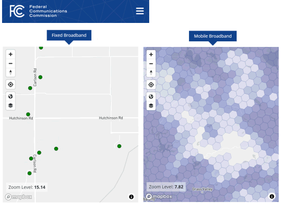
Click on the map to see what it says about your upload and download speed. Internet speeds are measured in megabytes per second (Mbps), and to qualify as 'broadband' the ISP must offer at least 25 Mbps for download and 3 Mbps for upload (that definition may soon be changing). Remember that the reported speeds are provided by the ISPs, and may or may not be what you actually experience.
Verify your mobile data speed
Want to keep going? Let's start by looking at how you can test your mobile (cellular) internet speed, and if you desire how to report what you actually experience.
To measure the actual connection speed you're getting on your phone or mobile device, you can download the 'FCC Speed Test' app (available for Android and iOS). A few caveats about using the mobile app:
- The whole point of the mobile app is to test the speed of mobile broadband. This means:
1) you need to disconnect from WiFi when you use the app to test connection speeds, and
2) testing is going to eat into your cell phone data usage. Many cell phone plans come with unlimited mobile data, in which case this may not be a big deal. But others give you a monthly quota, after which they slow down, cut off, and/or charge you more. When you install the app, you'll be asked how much data to allow it to use within your monthly billing cycle, from 500 MB up to 10 GB. - Sharing your data with the FCC is optional. If you just want to use the mobile app to see your connection speed, you can opt-out of sharing data and skip entering your name and email.
- The app does however require permission to access your location to run a test, even if you're not sharing the data. If this makes you nervous, there are other apps you can use to check your internet speed that don't ask for your location.
- The national mobile broadband map reports connection speeds outside. The FCC isn't particularly interested in how fast your cell phone data is inside your house, which of course is affected by all kinds of other things starting with how thick your walls are. You can use the app anywhere, but to submit data to the FCC make sure you step outside or go for a drive.
- Depending where you live, you may have noticed that internet speeds vary throughout the day. For example, when a lot of people stream video during prime time, individual speeds may go down. The FCC wants to know about that also. The app has an option to run tests periodically in the background. If you choose to enable this, it will still stay within the overall monthly cap you specified when installing the app.
Provide feedback on the fixed broadband map
The feedback the FCC wants on the fixed broadband map is a little different. Like the mobile app, they're interested in hearing if your internet speed is significantly different from what the ISPs report. But more fundamentally they're interested in whether the ISP service is actually available in practice. If you've tried to order service but the ISP never replied, or asked for an excessive installation fee, the FCC wants to know about that. They also want to know if your address is mislocated on the map, or in some cases missing completely!
To submit a challenge about the availability of service or the accuracy of a location, you essentially complete a web form. Click on the location on the map, and then either the ‘availability challenge' or ‘location challenge' links. For a preview of what that looks like, see this YouTube tutorial.
What about affordability?
We all know that ‘availability' only translates to ‘accessibility' if the service is affordable. For better or worse, the FCC national broadband map does not attempt to capture affordability. You can (and should) use the 'Availability Challenge' link to report if the installation fee for fixed broadband is excessive. However beyond that, the national map may not be the best place to register a complaint about broadband affordability.
Work with your community
While the FCC has made it easy to submit challenges to the map, that doesn't mean it will ask the ISPs to respond to every single submission. They need to see several challenges for the same area before they will aggregate them and ask the ISP to respond. So if you really feel the map needs to be reality-checked, encourage your neighbors and community to get involved. You will get feedback if your challenge is aggregated and sent to an ISP. Plus you never know, your efforts may just lead to an update on the map, with upgrades to infrastructure and service to follow!

