Six exits to safety: UC study finds wildfire survival depends on roads for evacuation
Interactive map shows wildfire risk based on number of roads out of a community
One of the strongest predictors of wildfire fatalities may be the number of roads out of a community, according to a new study from scientists at the University of California Santa Barbara and UC Cooperative Extension. Their research reveals that a surprisingly specific number of roads separates high-risk communities from safer ones during a wildfire – six.
Publishing in Proceedings of the National Academy of Sciences, researchers at UCSB's National Center for Ecological Analysis and Synthesis (NCEAS) and Bren School of Environmental Science compiled the most extensive georeferenced wildfire fatality dataset to date, covering 342 deaths across the United States from 2008 to 2024.
The scientists found that fatalities drop sharply as communities gain more outward road access, but only up to about six exits. Beyond that point, additional roads offer little further protection.
“The threshold near six exits held remarkably consistent across geographies, and communities of different sizes,” said lead author Caitlin Fong, NCEAS researcher. “That tells us it's a structural constraint, not a demographic one. Road redundancy is what saves lives.”
While having more than six exits doesn’t guarantee safety, the pattern is visible in some of the country’s most devastating fires. In the 2018 Camp Fire, 66 of 86 total fatalities occurred in Paradise in Butte County – a town with six outward roads that offered limited functional redundancy as fire and gridlock converged. Also in Butte County, 13 people were killed in Berry Creek –a community that had only two exits – during the 2020 North Complex Fire. In 2023, 102 people died in Lahaina, Hawai'i, a town with just four exit routes.
To assess the scale of the problem nationally, the research team combined egress data for every U.S. community under 50,000 residents with wildfire hazard maps and census population counts. Their findings are striking:
- 17.7 million people live in communities below the critical six-exit threshold
- 2.5 million of those people live in communities that also face high wildfire hazard
- 528 communities (typically small and remote) have no major road exits at all – spread across 41 states
- High-risk hotspots exist not only in the West, but also in Oklahoma, Florida and Hawai'I – states not typically central to national wildfire policy
“These maps show where wildfire has been deadly in the past,” Fong said. “Climate change means the future will look different. Places that have never had to think about evacuation routes are going to have to start."
“If you know you’re in an egress-limited community, you should have conversations with your family, your neighbors, your community about what your plan is,” she added.
Regardless of the number of exits available, the authors emphasized the importance of early evacuation. "Being prepared with a go bag and leaving as soon as possible can help reduce road congestion during evacuation,” said Moritz.
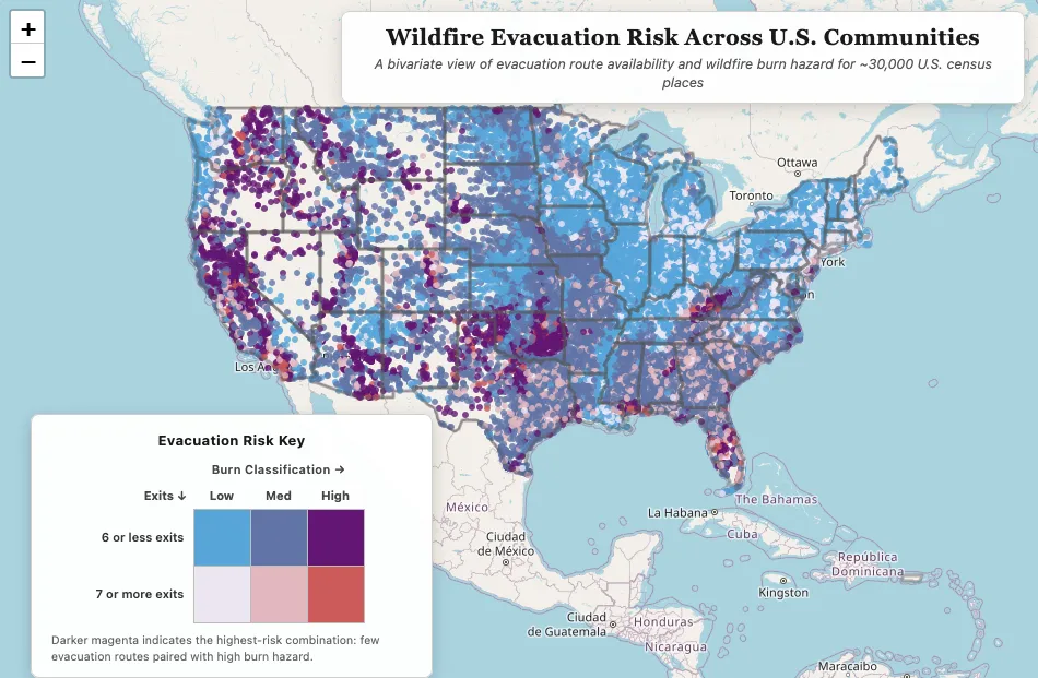
The scientists created an interactive map showing the vulnerability of communities across the United States based on the number of roads available for evacuation and wildfire hazard.
“There are 17 million Americans living in communities that, by this measure, are not designed to survive a fast-moving wildfire,” said co-author Max A. Moritz, UC Cooperative Extension statewide wildfire specialist. “That should be a wake-up call – not just for California, but for every state that thinks wildfire isn’t their problem yet.”
The researchers emphasize that road-building alone is not a complete solution – steep terrain, ecological constraints, and cost make new roads impractical in many places. They point instead to three complementary approaches: expanding egress infrastructure where feasible, improving early warning systems and evacuation behavior, and investing in pre-planned shelter-in-place options like temporary refuge areas for when evacuation fails.
Wide parking lots, ball fields and other open areas provide temporary refuge for people stay in their cars with the windows up until the wildfire passes.
“There are so many existing neighborhoods in fire-prone environments that have evacuation bottleneck challenges,” said Moritz, who used to live in the Bay Area, where the 1991 Oakland Hills firestorm killed 25 people. “Now we have a better analytical set of findings to identify where these are.”
The team’s risk maps, covering all small U.S. communities, are publicly available and designed to help planners, emergency managers and policymakers prioritize where to act first.
“People think of wildfire as a Western problem,” said co-author Benjamin Halpern, UC Santa Barbara professor of marine biology and conservation science and NCEAS director. “But we found communities with dangerous combinations of limited roads and high fire risk in places that don’t get a lot of attention. And as climate change expands fire hazard, that gap is only going to grow.”
Moritz hopes policymakers and city planners consider recommendations from the study.
“We can design new communities to be safer, paying more attention to ingress for fire suppression and egress for evacuation needs related to wildfire,” Moritz said.
“Because changing the road network of existing communities tends to be difficult and expensive, vulnerable areas need to have much better training, education and planning related to evacuation,” he added, noting residents need to know what to do if they can’t escape the wildfire area, such as seeking shelter in a pre-identified local refuge.
The study was funded by the Gordon and Betty Moore Foundation. The report, “Egress thresholds and wildfire fatalities,” authored by Fong, Carlo W. Broderick, Moritz and Halpern is published at https://www.pnas.org/doi/10.1073/pnas.2535081123
This research is part of the Wildfire Resilience Index, a project dedicated to building data-driven tools to help communities understand and build wildfire resilience. Learn more at wildfireindex.org.