By Michael-Anne Foley, Butte County Master Gardener, June 17, 2016.
Are you are confused by plant catalogs or magazine articles using different climate zone maps to describe the appropriate environment for particular plants? You are not alone.

The USDA plant hardiness map divides North America into 11 hardiness zones. Zone 1 is the coldest; zone 11 is the warmest. When you order plants from catalogs or read general garden books, you need to know your USDA zone in order to be able to interpret references correctly.
The 2012 USDA Plant Hardiness Zone Map compiled by the USDA and Oregon State University is based on the annual average minimum winter temperature over a 30-year period, and is divided into zones of 10 degrees each, further sub-divided into “a” and “b” zones of 5 degrees. Since 1990, the zone boundaries have shifted in many areas. Zones on this relatively new 2012 map are generally 5 degrees Fahrenheit (a half zone) warmer than those indicated on the previous map. This data was accumulated over the 30-year period before 2005; the more recent zone map based on this information was released in January of 2012.
The USDA map is now available as an interactive GIS-based map, for which a broadband Internet connection is recommended, and also as static images for those with slower Internet access. Users may also simply type in a ZIP Code and find the hardiness zone for that area. For example, using the USDA Hardiness Zone map, Chico, Oroville and Paradise are all located within Zone 9a (minimum winter temperatures of 20-25 degrees Fahrenheit). Although this is a useful plant hardiness index it has some important drawbacks: for example, it puts the Olympic rain forest into a zone with parts of the Sonoran Desert.
Gardeners in the western United States are sometimes confused when confronted with these 11 Hardiness Zones created by the USDA. A more useful index is the 24-zone climate system published in the Sunset Western Garden Book in collaboration with the University of California. The Sunset climate zone map for gardening was devised in the mid-20th century for thirteen western states. It has been expanded to include areas across the U.S., providing a more useful alternative to the USDA zone system.
The 24 Sunset Zones are determined by a number of factors to help gardeners identify the most appropriate plants for their needs. Winter and summer highs and lows are used to provide information about the temperature extremes in the region. Weather patterns like humidity, rainfall and heat are considered. The Sunset Zones also take into account specific environmental conditions like prevailing winds, day length and soil type.
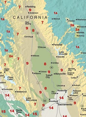
The greater precision of the Sunset system is evident in our local area: Chico is in Sunset zone 8, Paradise is in Sunset zone 7, and Oroville is in Sunset zone 9. Because the Sunset zone maps are more precise than the USDA's, they are considered the standard references for gardeners in the West. So, when you purchase plants for your zone, be sure you are using the right zone map! Sunset's zones 7 and 8 are much warmer than the USDA zones 7 and 8; mixing up the systems might well result in planting the wrong plant in the wrong place.
And keep in mind that even within a city, a neighborhood, or a street, microclimates can affect how plants grow. For example, planting tender citrus against a wall that absorbs daytime heat places it in a micro-climate that is warmer than a more exposed area. The zones are a guide and a good starting point, but you still need to determine for yourself what will and won't work in your garden.
For further information, check the following websites: