What does a careful analysis of our Mediterranean climate, historic climate patterns, and water supply reveal about our future here in Butte County? Specifically, what does the historical climate record tell us about for precipitation and temperature? How have groundwater levels changed over time? What do these trends and changes portend for our future?
California: A Floristic Hotspot in a Mediterranean Climate
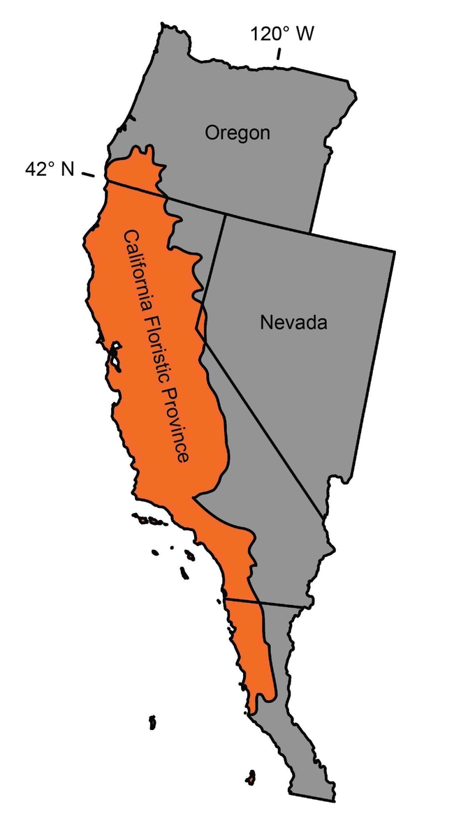
A “Hotspot” is a region that is rich in biodiversity and also threatened with destruction. To be termed a Hotspot, a region must have at least 1,500 species of vascular plants that are endemic (not found in any other location) and must have experienced a loss of at least 70% of its original natural vegetation. In addition, Hotspots support half of all plant and animal species, and more than half of endemic species, on Earth. The California Floristic Province stretches from southwest Oregon to northern Baja, and from the coast to the Sierra Nevada.
Of the five global Mediterranean regions, California has the greatest biological diversity, due to a unique combination of topography, climate, geology, and soils.
Atmospheric Rivers
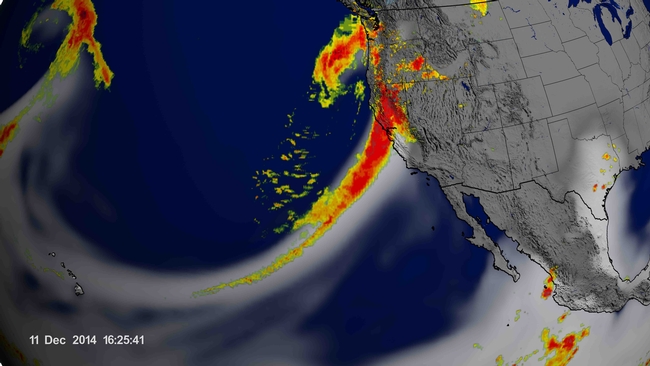
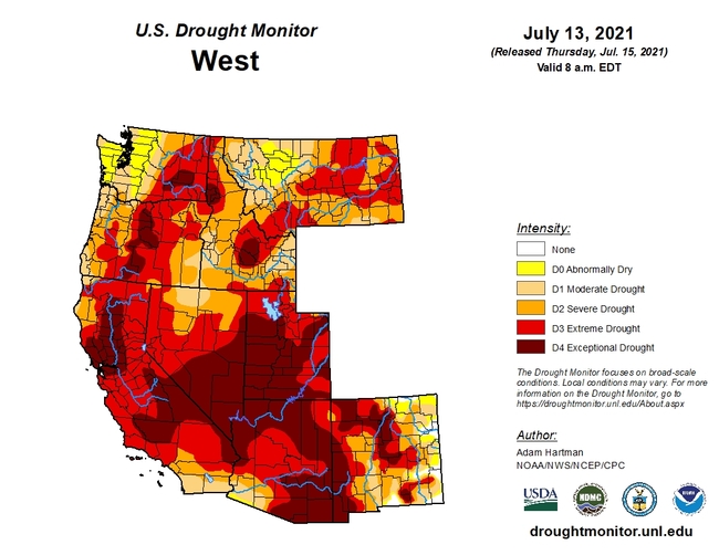
Extreme variability in rainfall is the norm for California's climate patterns. Most important is timing: when rain falls (or is absent) throughout the year. A few storms can make all the difference. We receive the majority of our rain (up to 75%) in just five months, and 50% of that in just three months. Atmospheric rivers provide a full 40% of our annual rainfall, and when high pressure ridges (such as the one aptly named the Ridiculously Resilient Ridge) keep these weather events from releasing their load of water onto our thirsty state, we experience one of California's historically common cyclical droughts, as has happened over the last few decades. Recently, droughts have been more frequent and more severe.
Water Supply, Temperatures, and Groundwater
One-third of our annual supply of water for agriculture and urban use comes from the Sierra Nevada snowpack. Frozen water melts gradually as the weather warms, filling rivers and lakes, and replenishing groundwater supplies. This is nature's way of helping us get through our dry, hot summers. We will likely continue to experience a decrease in annual snowpack due to climate change and the associated uptick in average temperatures.
According to NASA, the last decade has been the hottest on record with 2020 tying 2016 for the hottest year ever. In fact, in June 2021 over a thousand daily temperature records were broken, making it the hottest June recorded in North America. Low nighttime temperatures are warming faster than daily maximum temperatures. More nighttime temperature records were broken than daytime highs this June (NOAA,Global Historical Climatological Network). The rise in low temperatures during dormancy has implications for fruit trees that need a certain number of chill hours to produce fruit. Tip: When buying new fruit trees, select varieties that require a low number of chill hours.
As temperatures rise and the snowpack decreases, mountain soils dry out faster. These dry soils absorb more of the snowpack runoff that historically has filled our reservoirs. This spring, runoff was greatly reduced as the dry soils and vegetation soaked up any runoff before recharging our reservoirs.
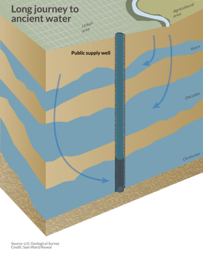
Groundwater is a crucial resource. The combination of low precipitation and high temperatures is especially damaging to our groundwater supplies. This underground storage system took tens of thousands of years to accumulate. In California, groundwater normally supplies 40% of our water needs. In dry years, groundwater accounts for 50% to 75% of our water use. The Chico urban area is 100% dependent on groundwater, and dry years here result in an even greater reliance on our groundwater aquifer.
Lack of rain and low snowpack means aquifers have less recharge since reservoirs do not fill, rivers have reduced flow, and surface water users have a reduced supply. When rainfall is scanty and snowpack is low, we naturally pump more groundwater for our daily needs. When drought cycles last for several years, groundwater supplies are diminished beyond the normal annual rainfall's replenishment capability. Several wet years are needed to see improvement in groundwater levels.
In a 15-year program that ended in 2017, NASA's Gravity Recovery and Climate Experiment (GRACE) satellites showed that between 2003 and 2013, some aquifers in California were depleted by up to 50% - a direct result of pumping groundwater. In some areas, particularly in the San Joaquin valley, we've consumed twice as much groundwater as has been replenished through rain and snow. In the Central Valley, applications for well drilling permits have skyrocketed, and wells have been deepened. Five wells in Kern County were recently drilled down to 2,500 feet! Practically speaking, well depth is limited by water quality and economics of pumping. At levels below 1,000 feet in the Sacramento Valley, groundwater becomes saline, a result of ancient marine sediments.
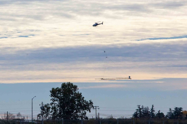
To better understand the structure of our local aquifer system, Butte County Water & Resource Conservation formed a partnership with Stanford University and CSU Chico to conduct an Airborne Electromagnetic Method (AEM) survey in 2018. Using a helicopter, the survey took an “MRI” of the ground to map the layers of sand, gravel, silt, and clay down to 1,500 feet. For an awesome video representation of the findings go to: https://mapwater.stanford.edu/. The California Department of Water Resources has an excellent two minute video explaining how AEM leads to a better understanding of our aquifer structures and soil layers.
By measuring the electrical resistivity, the composition of soil layers can be determined, leading to a better understanding of our aquifers and groundwater system. Local well data was used to aid in interpreting these findings. The information is being used to improve the hydrogeologic model for development and management of the Groundwater Sustainability Plans required by California's Sustainable Groundwater Management Act (SGMA). We are very fortunate that Butte County is ahead of the game in implementing SGMA.
Subsidence
Studies completed by the US Geological Survey showed that the water table dropped 100 feet in the Modesto area and 500 feet in the Tulare basin in recent drought years. In some areas of the Sacramento Valley, groundwater levels have dropped up to 13 feet.
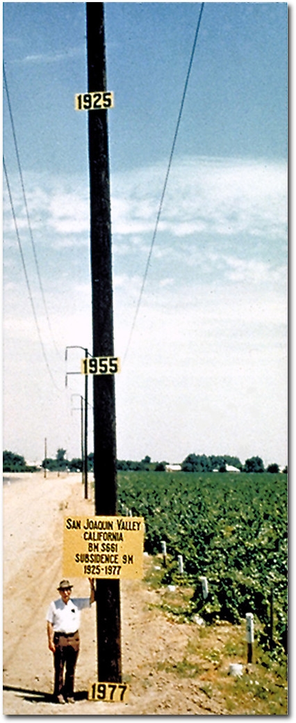
In basic terms, the ground deep beneath our feet is filled with sediment, layers of clay, sand, and gravel from ancient lakes and streams. These layers hold water. In some areas, a layer of clay separates the shallow groundwater storage pockets from deeper aquifers. Over-pumping deeper formations can compress clay layers, due to the weight of the overlaying land, and they can permanently lose some of their ability to hold water. This has been particularly problematic on the west side of the San Joaquin Valley. Fortunately, deep monitoring wells in Butte County have shown no evidence of subsidence due to the geological structure of the Tuscan aquifer.
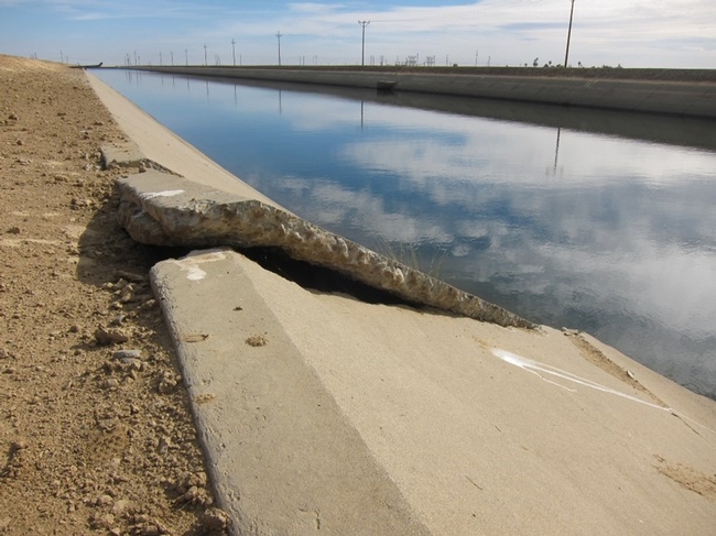
In economic terms, the damage to infrastructure can amount to hundreds of millions of dollars: subsidence damages canals that transfer water; buckles roads and bridges; causes pipeline damage; and can create fissures and depressions in the land itself.
How Did We Get Here?
Why do we plant thirsty plants and large, lush lawns, in a dry climate that is regularly threatened by drought, and irrigate them with a limited resource?
California has over 5,200 species of native plants, of which almost 30% are endemic, having evolved strategies to survive and thrive with sporadic rainfall, and through long dry summers. From wildflowers and shrubs (like poppies, Ceanothus, and manzanita), to our majestic oak woodlands, the Central Valley, foothills, and mountains of California are populated with a rich tapestry of sun-loving, drought resistant plants. But people moving west, particularly in the last century, longed for landscapes that reminded them of home, a look very different from the plants that covered the valleys and hills of California.
In the 1840's pioneers from the Eastern US began settling in California. The Gold Rush from 1849 through the 1850s and completion of the Transcontinental Railroad in 1869 led to a great influx of people from different climates. Settlers from the East arrived with their favorite agricultural seeds and plants tucked into their luggage. Fortunes gained from mining, agriculture, and timber harvesting allowed the development of ornamental landscapes using familiar, yet foreign, exotic plants. The Eastern landscape style brought to California by emigrants originated primarily from northern Europe and the eastern U.S. – where it not only rains a lot, but rains throughout the year.
Where Do We Go from Here?
Currently common irrigation practices and landscape designs are not sustainable. We've only gotten by with our present level of water use through our groundwater supply. Once that's evaluated and potentially limited by SGMA, changes will be required. The water resources needed to maintain our landscaping must become balanced and sustainable.
Historically, no one really knew the state of our groundwater supply. With the scientific tools we have now, we have a better grasp of our conditions. Satellite images, tree ring analyses, and AEM technology all give us a much better sense of climate trends, and how they all interact. Because of the latest technology, we can gain a good understanding of the conditions underground. The cool digital visuals allow us to understand in stark terms what's going on with groundwater. We can talk all we want about it, but it really hits home when we look at the graphs.
The UC Master Gardeners of Butte County offer many resources to encourage the shift from water hogging to more appropriate landscape choices. Our website, past and current Real Dirt articles, and Demonstration Garden all provide information and examples for making these changes in your own yard. Particularly helpful resources on our website include a list of Climate Appropriate Plants for the Northern California Landscape and a wealth of tips for Drought and Water-Wise Gardening.
In previous drought years we saw the start of a move to a more sustainable model: converting lawns to drought-tolerant landscaping; turning towards native plants; and minimizing water usage. This is encouraging. Social change moves slowly, but it's beginning. By understanding our climate, hopefully we can learn to garden within our means.
UC Master Gardeners of Butte County are part of the University of California Cooperative Extension (UCCE) system. To learn more about us and our upcoming events, and for help with gardening in our area, visit our website. If you have a gardening question or problem, email the Hotline at mgbutte@ucanr.edu (preferred) or call (530) 538-7201.
