


All Issues
Mapping vineyard expansion provides information on agriculture and the environment
Publication Information
California Agriculture 54(3):7-12. https://doi.org/10.3733/ca.v054n03p7
Published May 01, 2000
PDF | Citation | Permissions
Abstract
Vineyards are expanding rapidly in California's coastal counties due to a booming wine market. This change in land use has led to public debate over natural habitat removal, overproduction of wine grapes, loss of agricultural diversity, and changing scenery. Using a geographic information system (GIS) to map and analyze vineyard expansion in Sonoma County, approximately 11,600 acres of new vineyards were identified from 1990 through 1997. The total acreage was calculated to be at least 48,000 acres in 1997, 20% more than reported by county agricultural officials. Compared to vineyards established before 1990, a higher percentage of vineyards planted between 1990 and 1997 were located on hillsides that supported oak woodlands. Oak woodlands support a majority of the region's biodiversity, provide ecosystem goods and services, and have aesthetic value. This research was designed to document the effects of recent vineyard expansion on Sonoma County's hardwood rangelands and to provide tools for informed discussion and decision-making by land-use planners, farmers, residents and environmentalists.
Full text

California wines are popular nationally and internationally, resulting in increased demand for high-quality wine grapes, record-high wine bottle prices and increases in wine-grape planting. Over the past decade, shipments of wines that sell for $7 a bottle and up have increased 157% (Press Democrat, Nov. 1, 1999). The California wine boom has been an economic blessing for many rural landowners, who can reap significant value by developing their land into vineyards. Money from the California wine industry also makes its way into many facets of the local economy by providing jobs and increasing tourism. Many local governments promote continued vineyard development and encourage regional wine-making to improve economic vitality.
Statewide, wine grape acreage has approximately doubled since 1990 (California Agricultural Statistics Service 1999). In some places this new vineyard acreage is being planted in upland areas that support oak woodlands and forests. Conversion of undeveloped land to vineyards involves the clearing of native upland and riparian vegetation. This type of conversion has the potential to affect natural resources — increasing hillside erosion, impacting endangered species or impeding wildlife migration. In addition, increased vineyard development may lead to overproduction of wine grapes, loss of local agricultural diversity and changing scenery.
As a first step toward addressing these issues, we used a geographic information system (GIS) to map and quantify the extent of hillside development and rates of natural habitat conversion (see sidebar, below). This effort demonstrated that published statistics on vineyard acreage are incomplete and could be improved by better mapping.
How the geographic information system used here was built
In 1996 the Integrated Hardwood Range Management Program established a geographic information systems (GIS) lab at the UC Hopland Research and Extension Center. GIS is a computer mapping and analysis tool that allows the integration of large amounts of spatial and nonspatial information. We used a GIS to integrate a map of Sonoma County's vineyards with other digital information.
The digital vineyard maps used for this project were originally compiled by the Sonoma County Grape Growers Association and put into digital format by Circuit Rider Productions, Inc. to produce high-quality maps for tourists and wine enthusiasts. Vineyards were identified in the major appellation areas of Sonoma County using 1990 aerial photographs, and more recent vineyard developments were mapped from information provided by the grape growers themselves through 1997 (fig. 1).
Other digital information that was used includes elevation, slope and aspect data derived from U.S. Geological Survey (USGS) Digital Elevation Models (DEM); roads and streams from the U.S. Census Bureau; farmland and urban areas from the California Department of Conservation Farmland Mapping and Monitoring Program; and vegetation from the California Department of Forestry and Fire Protection 1990 hardwoods layer. Additional base layers were also obtained from the Sonoma County Information Systems Department GIS Division.
This integrated GIS was intersected with maps showing the location of vineyards developed before and after 1990 with elevation and slope derived from the DEM. We also used this GIS to extract all of the variables used in the vineyard expansion model. Areas that met the designated regulatory levels in the Sonoma County Vineyard Erosion and Sediment Control Ordinance were identified by intersecting existing vineyards with the DEM and soils data. To assess the potential future impact of this ordinance, we also intersected the areas identified by the vineyard expansion model as being the most likely to be suitable for future vineyard expansion. This GIS holds promise of being a powerful analysis tool that we hope to improve and use to continue this research to examine land-use changes, quantify the environmental consequences and provide policy and planning analysis.
— A.M.M.
Sonoma County findings
Sonoma County, which contains nine incorporated cities, is in the heart of the North Coast wine country and is one of the fastest growing counties in California. The U.S. Census Bureau reported a population increase of 282% from 1960 to 1995 (Census Bureau 1998). In addition to being one of California's premium wine-grape growing regions, Sonoma County's approximately 1 million acres include a substantial amount of hardwood rangeland (135,599 acres) and forests (561,468 acres) (ABAG 1996). Additionally, over 90% of the land is in private ownership.
A GIS was developed to analyze the amount and pattern of vineyard development in Sonoma County's major appellation areas, legally recognized wine-grape growing areas with specific geographic designations (fig. 1). We found that 11,663 acres of new vineyards were planted from June 1990 through June 1997, bringing acreage in grapes to at least 48,000 acres in 1997. This was 20% higher than the Sonoma County Agricultural Commissioner's estimate at the time. This larger figure was a surprise to most county residents, and was reported as front-page news with the headline, “New Sonoma County maps add 8,000 vineyard acres” (Press Democrat, June 1, 1998).
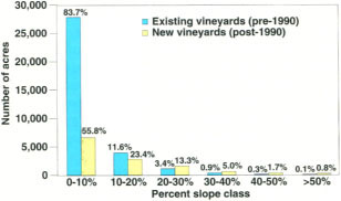
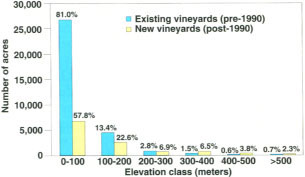
The GIS data layers used also included physiographic data such as slope, aspect and elevation (fig. 2). The integration of these data allowed us to demonstrate that upland areas are increasingly targeted for vineyard development. For example, in Sonoma County we estimate that 25% of the vineyards developed since 1990 were on slopes greater than 10 degrees (18% slope) and 42% were above 328 feet (100 meters) in elevation (figs. 3 and 4). By comparison, less than 6% of the vineyards established prior to 1990 were on slopes greater than 10 degrees, and only 18% were above 328 feet. There are several reasons that are probably driving the move upslope: (1) flat land is developed; (2) when available, flat land is more expensive; and (3) the microclimate found on hillsides can result in higher quality wine grapes.
The vineyards mapped in figure 1 were intersected with a 1990 digital vegetation map, allowing us to estimate the amount of undeveloped land converted to agriculture from 1990 through 1997. The 1990 vegetation map was derived from Thematic Mapper Satellite imagery provided by the California Department of Forestry and Fire Protection and was assumed to represent the vegetation cover types that existed in 1990. The vegetation analysis showed that approximately 1,631 acres of dense hardwood forest (greater than 50% tree cover), 278 acres of conifer, 367 acres of shrubland and 7,229 acres of oak grassland savanna were converted to vineyards between 1990 and 1997 in Sonoma County. It should be noted that these are slight underestimates, because vineyards outside the appellation areas in figure 1 had not been mapped and therefore could not be included in our analysis.
These GIS results demonstrate that Sonoma County has substantially more vineyard acreage than previously reported. Vineyards planted in the last 10 years typically occur at higher elevations and on steeper slopes than earlier plantings, resulting in the conversion of approximately 9,505 acres of undeveloped land.
Problems in estimating acreage
Based on our 1997 acreage estimates, the Sonoma County Agricultural Commissioner reported 51,500 acres of vineyards in the 1999 crop report (Sonoma County Agricultural Commissioner 1999). They added an estimated additional acreage of 3,500 to the 1997 figure of 48,000, itself 20% greater than the estimate that year. This estimate comes closer to the true acreage for the county than the 43,316 acres reported by California Department of Food and Agriculture (1998). Likewise, the Santa Barbara Planning Department (1999) estimated harvested wine-grape acreage at more than 18,000 acres for 1998, as compared to the Fruit and Nut Crop Report figure of 10,799 harvested acres (UC Fruit and Nut Research 2000).
Much of the difference between locally derived estimates of harvested acreage and published estimates is due to the fact that growers may not report reliably or may not yet be accounted for in the system. The counties with the most rapid vineyard development rates are often the farthest behind in reporting, and consequently have less reliable data.
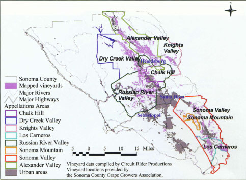
Fig. 1 Vineyards mapped within the major appellation areas of Sonoma County, including Alexander Valley, Russian River Valley, Chalk Hill, Dry Creek Valley, Knights Valley, Los Carneros, Sonoma Mountain and Sonoma Valley.
Other counties with expanding premium wine-grape acreage include San Luis Obispo with 14,988 acres reported (CDFA 1998) but actually closer to 23,000 planted acres (Deputy Agricultural Commissioner Robert Hopkins, personal communication, 1999), and Mendocino County with 14,264 acres reported (CDFA 1998) but closer to 17,000 actual acres (Agricultural Commissioner Dave Bengston, personal communication 1999). These discrepancies in wine-grape acreage figures indicate that a better system for mapping and monitoring agricultural change is needed. Aerial photography and other remote sensing technologies combined with GIS can be used to map and monitor agricultural areas and land use change as demonstrated for Sonoma County. This approach provides more accurate statistics on the amount of vineyard planted and could assist growers in determining whether current rates of production may exceed demand.
Advantages of mapping
Recently, environmental impacts and landscape change due to increased vineyard planting have been contentious issues in California. Federal courts have ruled that although landowners have the title to their land, they do not own the water, wildlife or other resources outright, and are responsible for managing these resources for the public trust (Araiza 1997). More information is needed to understand the consequences of vineyard expansion on a landscape scale as well as what site-specific vineyard development and management techniques can be used to minimize negative impacts to agriculture in general, neighboring landowners and the environment.
Advantages to agriculture.
The wine-grape industry is highly susceptible to economic downturns due to lack of information on future demand and how many tons of wine grapes will be produced when vineyards planted today begin bearing fruit (on average vines come into full production after 6 years). Quantifying the amount of bearing and nonbearing acreage is important for farmers, wineries, financial lenders and land-use planners to determine grape production, reduce the chance of over supply, and assess the environmental impacts of more vineyard development. Currently in Sonoma County, premium wine-grape growers can expect as high as $3,600 net revenue per acre of vineyard land in full production (Press Democrat, Nov. 1, 1999). A downturn in wine-grape revenues could more quickly bankrupt heavily leveraged growers than growers without heavy debt loads. However, wine industry executives forecast a favorable market for at least another 3 years (Wine Industry Financial Symposium Survey 1999), in the belief that increasing numbers of people will appreciate good-quality wines (Stuller and Martin 1994) and be willing to pay more than $7 per bottle. Economic optimism in the wine market prevails, despite the fact that wine-grape juice supply fluctuations in the past have led to large price drops and plowing up of vineyards, such as occurred in the Central Valley (Newsweek, Nov. 17,1995).
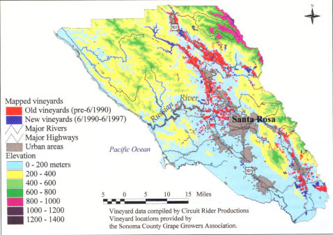
Fig. 2 Vineyards in Sonoma County with elevation classes. Vineyards mapped from 1990 aerial photos are in red; those mapped by the grape growers as newly developed since 1990 are in blue.
In addition, the loss of diversity in agricultural systems can have consequences for California agriculture. For example, in Sonoma County, reductions in crop diversity are due both to market value decreases in orchard commodities such as apples, and to the increased value of wine grapes. Today there are no prune orchards and less than 5,000 acres of apples; formerly these were the leading farm commodities in the county. The average price of apples was $130/ton in 1999, representing a 17% decline in price since 1998. Similarly, in Mendocino County pear and cherry orchards are being converted to wine grapes, and in Lake County both walnuts and pears are being replaced.
Moving toward a single agricultural crop across the North Coast is at odds with the principles of sustainable agriculture, and could lead to overreliance on a single industry. Proponents of sustainable agriculture promote increasing biodiversity in conventional farming systems to reduce insect pests and disease, and to reduce the use of insecticides, fungicides, herbicides and fertilizers (Bugg and Pickett 1998). In part this can be mitigated by planting a diverse suite of native cover crops in and around the vineyard.
Addressing residents' concerns.
The expansion of vineyards, especially on hillsides, can result in changing scenery and deforestation, which can affect water resources. Some Central Coast residents have expressed dissatisfaction with the landscape after grazing land was converted to vineyards (Los Angeles Times, March 23, 1999). Some landowners have also claimed reduced flow from wells after vineyard development occurred on neighboring properties. (Water use, always a contentious issue in California, is usually settled in the courts.)
Habitat conversion. Oak woodlands — including both sparsely covered rangeland and denser oak forests — have been used primarily for livestock grazing and wood products but are increasingly targeted for vineyard development. These natural areas also support valuable game species such as deer and wild turkey. Properties containing oaks or adjacent to oak woodlands often have higher market value than similar properties without oaks (Standiford et al. 1987). Ecologically, oak woodlands are the most diverse ecosystems in California, providing critical habitat for approximately 2,000 plants, more than 100 birds, 60 mammals, 80 amphibians and reptiles, and 5,000 insect species (Pavlik et al. 1991).
This habitat has already undergone fragmentation due to suburban expansion, thinning for range improvement and firewood harvesting. In fact, over a million acres of California's oak woodlands have been converted since 1950 (Bolsinger 1988). To complicate matters, several oak species are not regenerating adequately to ensure long-term species survival (Bolsinger 1988). Vineyard expansion in coastal counties represents one of the latest threats to California's coastal oak woodlands.
Although many vineyards are planted in treeless areas, the conversion of woodlands and forests is extensive at some sites. The Santa Barbara County Planning Department reported that the amount of vineyard land has doubled to 20,000 acres since 1996, leading to the loss of more than 2,000 oak trees, a larger number than development of rural subdivisions was responsible for removing in the past 10 years. Even in less well known wine-grape-growing areas such as San Luis Obispo County, an estimated 2,000 acres of rangeland are being converted to vineyards each year.
Converting oak woodlands to vine-yards has discrete and identifiable effects, including the loss of vegetation cover, displacement of wildlife, soil disturbance and habitat fragmentation (Garrison 2000). The California Department of Fish and Game (CDFG) has listed 15 species that may be preferentially affected by vineyard development in coastal California (Garrison 2000). In addition to habitat loss and fragmentation, impacts on creeks and wetlands have been the focus of the regulatory agencies. The CDFG lists increased sedimentation, introduction of nonnative fish species as a result of increasing the number of reservoirs, and loss of wetland habitat as issues of concern for watersheds with vineyard development.
Although our research focus has been on oak woodlands, some North Coast vineyards have replaced conifer-dominated forests that include redwood, Douglas fir and tan oak trees. However, very little data on this trend exists for Sonoma County because it has occurred so recently and is not reflected in the available maps and statistics on vineyard acreage.
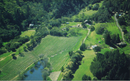
A vineyard on the edge of an oak woodland in Sonoma County, where oaks are gradually being removed and replaced with grapevines.
Research needs
Integrating spatial information on agricultural areas with other information about the landscape such as topography, hydrography and vegetation allows us to determine which watersheds may be disproportionately affected by vineyard development.
As we have demonstrated here, GIS is the best tool to do this, however, there are many areas in need of improvement. We would like to improve our mapping capabilities across a larger geographic area so that we can monitor the North Coast's rapidly changing landscape. An essential improvement would be to use remote sensing data for the mapping and monitoring of vineyard expansion across a larger geographic region and to assess changes in development patterns at regular time intervals.
Additional information on soils, climate, geology and water would also be of great benefit in analyzing vineyard development patterns. Higher resolution topographic information is becoming available and will improve our analysis capabilities as well. A combination of these improvements and further analysis of the relationships between land use and environmental conditions should prove valuable to those interested in agricultural land-use planning and environmental protection.
Brochure explores vineyard expansion issues
Vineyards in an Oak Landscape gives practical information on how to assess land-management decisions and balance agricultural production with natural-resource conservation. The brochure discusses the unique values of oak woodlands in California, the threats facing oak woodlands and how to care for existing oaks.
Along with information on oaks, the brochure outlines current information on disease, economic incentives and management practices. To obtain a $4.50 copy of publication number 21577, call DANR publications at (800) 994-8849. — A.M.M. and Julia Crawford
Mapping vineyard expansion provides information on agriculture and the environment

