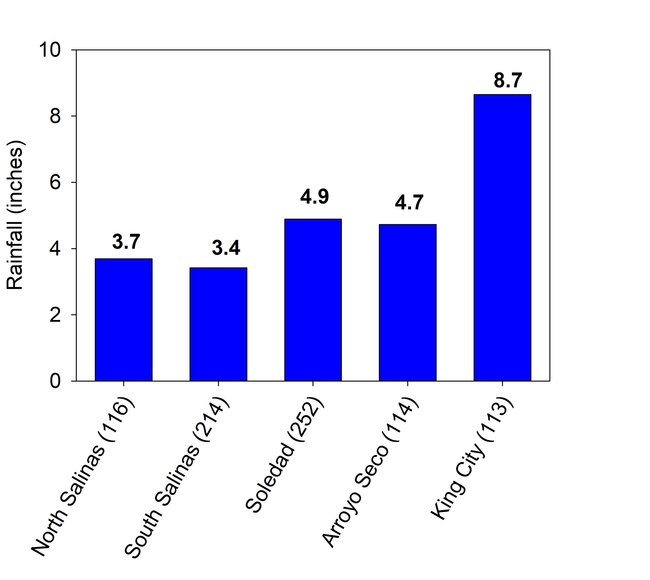
The rain situation was beginning to look dire for our region before last week, with most major storms passing to the north of Monterey county. However, the storms that occurred last week were generated by an atmospheric river that was focused on the southern part of Monterey County. Cumulative depths recorded at CIMIS weather stations along the valley showed increasing amounts moving south in the valley with almost 9 inches recorded at the King City CIMIS weather station (station 113) (Fig. 1). Also 8.3 inches were recorded at San Antonio and Nacimiento Reservoirs, where before these storms less than an inch of rain had fallen since October.
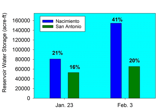
This one weather event was able to significantly increase the water stored in Nacimiento reservoir and helped the situation in San Antonio (Fig. 2.) Nacimiento water storage increased from 21% to 41% between January 23 and February 3, and San Antonio increased from 16% to 20% capacity. In combination, water stored in the two reservoirs increased from 133,778 acre-ft to 216,858 acre-ft, representing 64% more water compared to before the storm events. Total capacity of the two reservoirs is 712,900 acre-ft, so water stored in the reservoirs at this point in the season is still at 30% of maximum capacity.
Our region usually receives a few atmospheric river events each winter, most of which usually pass too far north or south to greatly impact the Salinas Valley reservoirs. This first major rain event of the season was a direct hit for the reservoirs. Hopefully, more rain will be coming in the upcoming weeks.
The other benefit of this last storm was that by mostly passing over the southern part of the county, debris flows were minimized in the burned areas.
If you want to keep track of the reservoir storage as we proceed through the winter visit the link at Monterey County Water Resource Agency website.

