- Author: Lauren Foster

The caption on an old tourist sign in Exuma Cays Land and Sea Park: “Water, water everywhere but not a drop to drink.”

Image: Black Point, Exuma Islands, Bahamas. Photo: Lauren Foster
The full moon is high when my sister and I slip off our 44 foot sailboat to row ashore on Warderick Wells Cay in the Bahamas. Locals in the area assert that if you climb to the highest part of the island at night you can hear cries on the wind, though the varied history of piracy and shipwreck at this spot make the ghosts' identity a mystery.
In the early 18th century it was a hideout for many of the more notorious pirates of the Caribbean and as I look to the south I can see three islands named after Mary Read, Anne Bonney, and Edward Teach (Blackbeard). This spot was an ideal hideout for these famous pirates because it has a protected, hidden harbor deep enough for 12 foot draft pirate ships; a clear view of merchant ships headed through a narrow channel for the Bahama banks from the North Atlantic; but, perhaps most importantly, it is one of the few islands in the area with a supply of fresh water (Exuma Cays Land and Sea Park).

Image: Bronze sculpture of Mary Read and Anne Bonney by Erik Christianson (http://www.erikchristianson.com/sisters-of-the-sea/). Anne and Mary are famous for standing their ground in an attack from Jamaican law enforcers while the rest of their crew fled belowdecks. Mary yelled to her comrades: “if there's a man among ye, ye'll come up and fight like the man ye are to be!” (Abott, 2011).
According to the United Nations, fresh water is designated as a ‘scarce' resource if a country has less than 1,000 m3/capita/year. At 66 m3/capita/year the Bahamas ranked number 177 out of 180 countries for water availability in 2002. The main sources of water in the Bahamas are fresh water lenses in Pleistocene and Holocene limestone aquifers (see Figure 1). Precipitation percolates slowly through the porous limestone, settling on top of the saline seawater because the fresh water is less dense. The rock acts as a freshwater reservoir, slowing the rate of flow and thus the rate of mixing between the fresh and salt water (Army Corps of Engineers, 2004).

Figure: Hydrogeology of a Bahamian fresh water lens. The shallow sea, called the Bahama Banks, is located on the west side of the Exuma Cays, while the deep sea is located on the east side facing Exuma sound and the North Atlantic. In the Exumas the maximum depth of freshwater lenses is 16m, though most are only a meter or two below the land surface. The specific capacity of these aquifers is quite small, making modern groundwater development impractical (Army Corps of Engineers, 2004).
The country depends on desalinization plants and bottled water in addition to their small natural supply of freshwater. Beyond that, however, conservation is a necessary part of sustainable water use. Residential consumption is estimated to be between 150-200 liters/person/day. This is a sharp contrast to the tourist consumption of 400-1,000 liters/person/day (Integrated Coastal Management Planning, 2012). This discrepancy demonstrates that tourists from mainland areas have a lot to learn about water conservation.

Image: Our Alden 44 sailboat, HoKa, and my home for two weeks this winter. Photo: Lauren Foster
Living on a 44' sailboat for two weeks in the Exuma Cays provided me with direct experience focusing on consuming a minimal amount of fresh water. Our boat holds about 500 liters of water. We refilled 270 liters halfway through the trip. That meant we were consuming no more than 15 liters/person/day in spite of having most modern conveniences like a shower, bathroom and kitchen sink, toilet, refrigerator, and freezer. We did not carry any bottled water. Here are some of the key practices we employed to conserve water without sacrificing comfort:
- We took navy-style showers: turn the water on to get wet, turn it off to soap or shampoo, then turn it on to rinse.
- While rinsing off in the shower could be a daily occurrence, showering with soap and shampoo was limited to every few days.
- When washing dishes we would soak them first in, for example, the empty (but dirty) salad bowl or pot. After emptying the super dirty water, we would soap each dish without running water. Silverware would get rinsed in a clean water glass. I would rinse glasses using the same amount of water, pouring from one to the next until the water was too soapy. Plates I rinsed one at a time, but in a stack so each one partially cleaned the ones below.
None of these practices were uncomfortable, inconvenient, or even slower than the way I do things at home. I was able to brush my teeth each night with a sink, wash my hands often, and shower regularly. I intend to continue practicing these conservation techniques on the mainland because the truth is we need to conserve water in the Western United States too. In California residential use has dropped from 880 liters/person/day to 670 liters/person/day over the past 20 years (Mount 2014). Can you imagine the impact of each person consuming only 15 liters/person/day?
My awareness of the value of fresh water has been sharpened by my weeks on the boat, so as I climb Boo Boo Hill in the darkness I understand how access to fresh water was a key piece of Blackbeard's successful piracy in the Bahamas. It makes sense that Mary Read and Anne Bonney would choose this particular cay to wait for unknowing ships to come through. Though the night is still, as we near the crest of the hill we hear a sound like wind in a tight tunnel or a sharp intake of breath. Almost as if there were thirsty ghosts wandering the tides to find one sip of that precious, life-giving resource: fresh water.

Image 5: Bringing some UC Davis Hydrology schwag to the Bahamas! Photo: Kathryn Foster.
References:
Abbott, Karen (2011). “If there's a man among ye: the tale of pirate queens Anne Bonny and Mary Read.” Smithsonian Magazine. http://www.smithsonianmag.com/history.
Army Corps of Engineers (2004). “Water resources assessment of the Bahamas.” http://www.sam.usace.army.mil/Portals/46/docs/military/engineering/docs/WRA/Bahamas/BAHAMAS1WRA.pdf
Christianson, Erik. “Sisters of the sea.” Bronze sculpture. http://www.erikchristianson.com
Exuma Cays Land and Sea Park. http://www.exumapark.org/
Integrated Coastal Management Planning (2012). “Integrating watershed and coastal area management in the small island developing states of the Caribbean: Technical Report: National Report for the Bahamas.” http://iwlearn.net/iw-projects/1254/reports/bahamas-national-report.pdf
Mount, Jeffery; Freeman, Emma; Lund, Jay (2014). “Water Use in California.” Public Policy Institute of California. http://www.ppic.org/main/publication_show.asp?i=1108
- Author: Katherine Markovich
We've had several weeks now to fully recover from the most recent American Geophysical Union (AGU) Fall Meeting, which takes place in San Francisco each December. The AGU Fall Meeting is the largest geoscience-centric conference in the world, bringing together nearly 20,000 attendees in 2014. This was my second time attending; the first time was several years ago when I was still a wee undergrad from UT Austin presenting the fruits of my Honors Thesis. It was during that 2011 AGU Fall Meeting that I stumbled upon the CCWAS booth, and having never heard of IGERT traineeships, was immediately intrigued by the opportunity.
Three years and three cohorts later, the CCWAS booth still had a strong presence in the exhibitor hall, but we also had an incredible showing in the form of oral, poster, and pop-up talk presentations. Here's a brief recap.
CCWAS Principal Investigators
Reed Maxwell gave an invited talk on hyperresolution integrated modeling of groundwater and surface water scaling over the continental US as part of an all-star session with other hydrology big hitters such as Dennis Lettenmaier,
Bridget Scanlon, and Jay Famiglietti. Graham Fogg spoke about his work with the connected network paradigm, which is a potential solution to the observation bias in hydraulic conductivity measurements for regional groundwater flow and transport modeling.
2012 Cohort
Alison Whipple, who recently advanced to PhD candidacy, gave a poster on characterizing past and future flood regimes of the Cosumnes River. Her work moves beyond the traditional flood frequency methodology with novel statistical cluster analysis and ecologically relevant metrics. Posters also included Alan Rhoades with a poster on his work with variable resolution modeling of Sierra Nevada snowpack. He developed a 25-year ensemble climatology for the region within the Community Earth System model (a global climate model), which provided an exciting case study for the variable resolution approach.
2013 Cohort
Laura Condon gave an invited talk on the spatial patterns gleaned from her work on the high-resolution integrated hydrologic model of the Continental US. She found that topography as opposed to recharge controls the water table in the arid West at the regional scale, but that subsurface heterogeneity complicates those patterns at the local scale. James Gilbert gave a poster presentation on his modeling research, which focuses on the impacts of climate change on the San Joaquin basin—arguably ground zero for the clash between agricultural production and groundwater overdraft in California. Lauren Adams' poster had such a clever title that I dare not paraphrase it: “Better Redd than Dead: Optimizing Reservoir Operations for Wild Fish Survival During Drought.” Katie Markovich gave a poster presentation on her work using integrated hydrologic models to characterize the relative impacts of future climate scenarios on alpine hydrology, as well as the hydrogeologic controls on feedbacks to warming and drought. Jorge Guerra's poster focused on Tempest, a modeling framework he is developing that allows for investigation and intercomparison of high-order numerical methods, and improves atmospheric dynamics in the vertical direction where existing methods are deficient.
2014 Cohort
Stephen Maples used his work with the USGS Nevada Water Science Center for his poster, which identified plant-produced organic compounds as pathways and reservoirs for tritium transport in the Amargosa Desert. Alejo Kraus-Polk gave an engaging pop-up talk on reconciling human needs with hydroecological health of the San Joaquin River. The pop-up sessions are a new addition to the AGU Fall Meeting, where early career students can gain experience communicating their research in a creative yet concise format.
Ultimately, we socialized, we talked about research, we exchanged business cards, and we all had a great time. Looking forward to seeing what CCWAS brings next year!

- Author: Stacy Roberts
|
|
On Saturday, November 15th, several CCWAS students, along with students in Jay Lund's water management course and Rick Frank's environmental law class, took a tour of the Delta. From seven in the morning until five at night, we drove over bridges, on top of levies, and all around the islands that make up this hydrologic empire. Mountains and water, fog and sun, rural areas and urban-- it can all be found here. The last stop we made before returning to Davis was Locke, a former Chinese worker town where those who built the levees lived. Visiting the town reminded me of how the ecological richness of this estuary reflects and is responsible for the equally rich social history embedded in the landscape. As Rick Frank explained, in the comparatively “unenlightened” social world of the later nineteenth century, white men may have capitalized reclamation efforts and owned the land in the Delta, but it was Chinese gang laborers who actually completed the work. Thereafter and until the Great Depression of the 1930s, Delta farms produced high-value specialty crops such as asparagus, potatoes, and sugar beets, which were planted, pruned, picked, and canned by Chinese, then Japanese, and then Filipino workers. Each successive group of people came to fill the labor void left by restrictive immigration laws, such as the Chinese Exclusion Act of 1882, which barred Chinese laborers from entering the United States. In addition, prevailing racial ideologies of the late-nineteenth and early-twentieth centuries viewed people coming from Asia as naturally suited for the “exacting” stoop labor required of “inferior” truck crops. Such work was too menial for white people and did not suit their bodies, went the thinking of the day. This should give us pause and force us to think about how the terms “nature” and “natural” were used and how those meanings have changed over time1. “Nature” meant something very different to nineteenth-century Americans than it does to us today. Not only were there “natural” racial hierarchies, but the non-human world was imbued with symbolism and meaning foreign to our own thinking. The businessmen and farmers who sought to “improve” the malarial wetlands in the Delta and Central Valley believed they were “finishing nature” and fulfilling God's plan on earth by bringing order to a chaotic landscape. Federal and state laws supported them. Their actions consisted of a subset of the human species altering a landscape to meet material wants and needs. Was their work unnatural? |


On Saturday we saw a different arrangement of water, soils, plants, animals, and human settlement than existed one hundred, two hundred, or even two thousand years ago. Does that make it unnatural?
As we were leaving the Delta smelt research and breeding facility, Alejo and I visited with a law student who seemed discombobulated about everything we had just learned. The smelts' entire life cycle and breeding patterns are concocted and controlled by biological engineers. Researchers and resource managers do not want the hatchery fish released into the wild unless there is a severe drop in wild Delta smelt populations because uncertainty remains as to whether breeding between the two would produce adverse genetic effects. And yet, engineered Delta smelt are fish just like any other fish—they swim, eat, behave, and have fish genes just like any other fish. But are they natural?
Historians do not provide clean, neat answers to questions or problems that arise. In fact, our job is to complicate and add nuances to stories and ideas. The terms “nature” and “natural” are not static and unchanging; they, too, have a history and are culturally constructed. But I think we would do well to heed what eminent historian Richard White wrote in his introduction to The Organic Machine: “We might want to look for the natural in the dams and the unnatural in the salmon” and “find, paradoxically, along those blurred and dirty boundaries ways to better live with our dilemmas." 2
Notes
1 Matthew Morse Booker, Down By The Bay: San Francisco's History Between the Tides (Berkeley and Los Angeles: University of California Press, 2013), 104-105; Cecilia M. Tsu, Garden of the World: Asian Immigrants and the Making of Agriculture in California's Santa Clara Valley (New York: Oxford University Press, 2013), 28-30.
2 Richard White, The Organic Machine: The Remaking of the Columbia River (New York: Hill and Wang, 1995), xi.
- Author: Carole Hom
- Author: Lauren Adams
Under recently enacted legislation, local agencies in California are required for the first time to manage groundwater pumping and recharge sustainably.
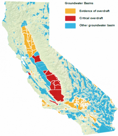 |
The law empowers local groundwater agencies to manage and use groundwater “without causing undesirable results,” leaving it up to them to determine how to best achieve this goal. Within the next six to eight years, agencies in groundwater basins subject to critical overdraft must adopt plans that put these areas on a path to sustainability by 2040. A major factor complicating such long-term water planning is climate change. Failing to account for a changing climate will put agencies -- and the people whom they serve -- at risk of “undesirable results,” even if they are otherwise well prepared. The solution: a long-term approach to groundwater management will result in more resilient groundwater basins and a more secure water system for California. |
To read more about climate change, groundwater security, and the new package of groundwater legislation, read the full post, “Groundwater security, for the long term” on the California Water Blog at http://californiawaterblog.

