Creating defensible space and shaded fuel breaks in the Wildland Urban Interface
-
Julie McMillan
-
Wildfires are more frequent, intense, and destructive due to increased vegetation (because of fire suppression), climate change, and more homes in the Wildland Urban Interface (WUI), where residences are built near wildland or open spaces. About 20% of Marin land is in the WUI, with about 69,000 residences assessed at over $60 billion. Access roads may be narrow, winding, and on hillsides with overgrown vegetation, making it difficult to protect homes and lives. It is imperative for homeowners in the WUI to create and maintain defensible space. The Marin Wildfire Prevention Authority (MWPA) is also addressing the challenging conditions in the WUI by modifying dense forest vegetation in strategic locations to reduce future fire intensity and allow fire crews safe access to slow fires and protect lives and property. These vegetation management projects are referred to as shaded fuel breaks or fuel reduction zones.
Since the 1960s, California law has required that homeowners do fuel modification around their homes. Local jurisdictions have had similar rules for more than 100 years! According to Todd Lando, Central Marin Fire’s Hazard Mitigation Specialist, “burning homes produce enormous amounts of embers, far greater than vegetation fires. So a key to preventing catastrophic megafires is keeping homes at the edge of the WUI from igniting.”
All homeowners need to create and maintain defensible space to help protect their homes from wildfire. Here are the steps to take:
- Zone Zero: 5’ perimeter surrounding your home, which is the most vulnerable area and should be more aggressively maintained for fire resistance: remove all combustible materials, including plants, organic mulch, and dry leaves, from your roof and gutters; relocate garbage and recycling containers, trash, firewood, patio accessories, natural fiber doormats, and combustibles under decks
- Zone 1: 5’-30’ from your home: remove dead plants, grass, weeds, leaves, and needles; keep branches at least 10’ from your home and other trees; install low, well-irrigated native plants; break up mulched areas with hardscape; avoid gorilla hair mulch
- Zone 2: 30’-100’ from your home: remove dead fuel, invasives, and lower tree branches; keep grass to 4” maximum; separate shrubs and trees based on type and size, and your land’s slope (the steeper the slope, the greater the spacing)
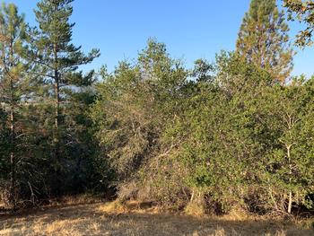
The MWPA also protects homes in the WUI by modifying dense forest vegetation in strategic locations around homes and critical improvements and creating shaded fuel breaks or fuel reduction zones. These are unlike emergency fire breaks, where all vegetation is rapidly removed, usually by bulldozers, to try to stop an approaching wildfire. A shaded fuel break is carefully planned and gentle on the environment, keeping the forest canopy for shade and moisture retention. Workers remove lower tree limbs, dead material, and invasives, primarily by hand. A shaded fuel break slows and cools a fire, decreasing its intensity as it approaches homes, making it easier to suppress, resulting in less destruction and safer evacuations. When the 2021 Caldor Fire reached a shaded fuel break, flames dropped from 110’ to 15’ high, allowing firefighters to save the Lake Tahoe area. Shaded fuel breaks also improve forest health by reducing non-native plant cover. Before treatment, an area of the Greater Ross Valley Shaded Fuel Break contains lots of underbrush & dead materials. Photo Credit: Anne Crealock, MWPA
The MWPA is currently creating or planning these shaded fuel breaks (with more to come):
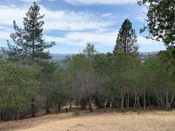
 After treatment, a similar area of the Fuel Break is cleaned up, with dead materials removed & trees limbed up. Photo: Anne Crealock, MWPA
- Greater Novato Shaded Fuel Break, around Novato, 200’-300’ wide, approximately 45 miles long, encompassing over 1,900 acres.
- Ridgewood Shaded Fuel Break, 75 acres on the Terra Linda/Sleepy Hollow divide on Marin County Parks land
- Terra Linda/Sleepy Hollow Divide Fuel Reduction Zone in the Terra Linda, Mont Marin, and Sun Valley WUI neighborhoods; 8 miles long on 26 acres owned by Marin County Parks and Open Space and San Rafael
- Greater Ross Valley Shaded Fuel Break, adjacent to WUI areas in Corte Madera, Larkspur, Kentfield, Ross, San Anselmo, Fairfax, and San Rafael; 38 miles long and about 200’ wide, adjacent to 1,600 private parcels, 1,313 acres
- Mill Valley Shaded Fuel Break, 39 acres
- Tamalpais Valley/Homestead Fuel Break, 22 acres
Everyone must do their part to create and maintain defensible space, especially for homes in the WUI.


