ET: Evapotranspiration and Plant Water Use

The physiology and structure of plants and weather conditions are the primary factors affecting ET. Primary weather variables that affect ET are:
- sunlight (solar radiation)
- air temperature
- relative humidity
- wind speed
These weather components determine the amount of energy present to evaporate water and drive transpiration. Generally, as sunlight, temperature, and wind increase and as relative humidity decreases, ET of a plant or planted area increases, provided soil water content is adequate. If soil is relatively dry, the ET rate will be reduced even if weather conditions support a high ET rate. Frequent wetting of mulch or the soil surface, as occurs with daily overhead irrigation, can maximize the ET rate of a planted area by increasing the amount of water that evaporates from soil, mulch, and plant surfaces.
Studies on the water use of pasture grass and agricultural crops led to the development of relationships for predicting ET from weather data. Local weather data is entered into complex mathematical equations derived from these studies to calculate an estimated ET value for a given location and period, usually a day. Since it would be too cumbersome and complex to generate ET values each day at numerous locations for thousands of different plants, a single standardized value known as ETo or reference ET can be calculated at numerous locations to reflect the influence of local weather and climate on plant water use. An ETo value is the estimated water use of cool-season pasture grass (tall fescue, the reference plant) given unlimited water, growing four to six inches in height, and maintained in optimal, non-stressed condition.
In landscapes, ETo accurately estimates the water demand of lawns and other uniform turf areas, but it marginally represents the water demand of non-turf, non-uniform, physically and biologically diverse plantings. The water use physiology of many landscape plant species, the canopy structure of landscapes, and the less demanding performance expectations placed on landscape plants conflict with the same components in agricultural crops upon which ETo estimation is based. The model and equation developed to calculate ETo are simply not robust enough to capture the complexity of factors affecting the water demand of a landscape.
In most areas of California, ETo is maximum in July and minimum in December. Daily ETo in non-desert locations ranges from near zero in cool, moist seasons and periods to just over 0.3 inches during July, although locations near the coast and those that receive significant summer marine layer cloud cover seldom experience ETo much over 0.2 inches per day. Desert locations regularly experience summer daily ETo rates of 0.3 inches and higher.
Estimating ETo
Real-time ETo Data

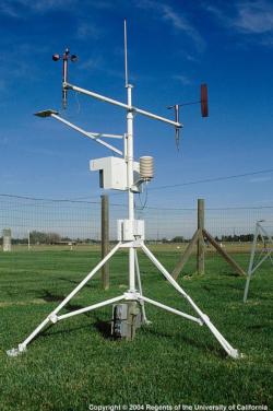
Real-time daily ETo data from CIMIS is calculated from hourly average data gathered from weather station sensors using a modified Penman equation and the Penman-Monteith equation. Scientists at the University of California and California Department of Water Resources worked jointly to develop the CIMIS system.
Average or Historic ETo Data
Monthly and annual average or historic ETo values, calculated as average values over several years, are available for all active CIMIS stations and 85 additional inactive CIMIS stations. To access average ETo data, login as a user at the CIMIS Web site and follow the “Data” tab, then select “Monthly Average ETo”.
Average ETo data is valuable in estimating water budgets, predicting plant water use, and setting base irrigation schedules. One can irrigate with reasonable accuracy using historic ETo data, but actual daily ETo can vary significantly from the long-term average, so more precise irrigation schedules and maximum water conservation are attained by using real-time ETo data. For example, average ETo for a day in May in Riverside is about 0.19 inches. However, during May 11-12, 2014, the real-time daily ETo was over 0.30 inches, while on May 7 and 10, 2014 the real-time ETo was 0.16 inches.
Smart Controller ETo Data
Some sophisticated irrigation controller systems have sensors that collect weather data and calculate estimated ETo on-site. These systems can provide accurate data if the sensors are high quality, positioned according to required standards, and well-maintained to keep them functioning. Otherwise, the data collected will result in inaccurate estimates of ETo.
Other smart controllers access or receive real-time or average ETo data from a source located off-site. It is important to assure that the source uses accurate weather data to estimate ETo.
For any irrigation controller using ETo data, it is important that ETo is calculated using the equations CIMIS uses, the ASCE Standardized Reference Evapotranspiration Equation, or an algorithm proven equally accurate in estimating ETo.
