University of California Cooperative Extension has recently expanded their team of fire advisors and staff. This new group of UCCE fire professionals is interested in learning about the concerns of the communities that UCCE serves, as well as the natural resource professionals already working to address these issues.
Results from this survey will enhance the team's ability to partner with residents, landowners, agencies, academics, and other organizations to reduce California's vulnerability to wildfires. These new advisors will also share survey results with UCCE colleagues throughout the state, who already provide important fire-related programming across diverse landscapes and audiences.
"Wildfires will continue to affect all Californians, either directly or indirectly," said Katie Low, UCCE statewide fire coordinator. "It's invaluable to have the input of as many people as possible to guide the development of our wildfire-related extension programs, so that they can provide the most useful resources and information to communities across California."
The survey asks questions about topics such as:
- Gaps within existing educational programming and resources
- Challenges community members are facing in addressing wildfire risk
- Empowerment of communities to make property management decisions and prepare for wildfire
- Acceptability of prescribed fire and other fuels treatments
By participating in this study, you can choose to enter a drawing to win one of fifty $20 VISA gift cards.
To take the online survey, please visit https://bit.ly/UCCE_Fire_Survey.
This research is being led by a team of new UCCE fire advisors and staff. If you have any questions about this survey, please contact the fire/forestry professionals involved in this survey effort:
- Luca Carmignani, UCCE fire advisor for Los Angeles, Orange, Riverside, and San Diego counties, carmignani@ucanr.edu
- Alison Deak, UCCE fire advisor for Fresno, Madera, and Mariposa counties, aldeak@ucanr.edu
- Katie Low, UCCE fire academic coordinator for Nevada and Placer counties, katlow@ucanr.edu
- Barb Satink Wolfson, UCCE fire advisor for Monterey, San Benito, Santa Clara, and Santa Cruz counties, bsatinkwolfson@ucanr.edu
- Ryan Tompkins, UCCE forestry advisor for Plumas, Sierra, and Lassen counties, retompkins@ucanr.edu
For more information about wildfire-related programming from University of California Cooperative Extension, please visit https://ucanr.edu/sites/fire/ or the Facebook page https://bit.ly/fireSolutions.
Posted on
Thursday, February 9, 2023 at
5:07 PM
Tags:
Alison Deak (2),
California (167),
Carmignani (2),
climate (45),
development (19),
fire (152),
Katie Low (2),
programs (1),
residents (2),
resilience (2),
risk (4),
Ryan Tompkins (14),
Satink (1),
statewide (4),
survey (36),
wildfire (355),
Wolfson (1)
Focus Area Tags: Environment
The reach of The Nature Conservancy (TNC) is global, with projects that range from pristine...
Posted on Friday, December 30, 2022 at 5:00 AM
Focus Area Tags: Yard & Garden
Spotted lanternfly (Lycorma delicatula). Photo by Surendra Dara
The spotted lanternfly (SLF) [Lycorma delicatula (Hemiptera: Fulgoridae)] is an invasive planthopper, which causes a significant damage to apples, grapes, stone fruit, trees used for timber, and other hosts (Dara et al. 2015). Native to China, SLF was first reported in 2014 in Pennsylvania and has been rapidly spreading in the eastern United States and moving westward. California has 22 cultivated and about 70 wild hosts of SLF and include several high value crops such as apples, cherries, grapes, and plums. The tree-of-heaven, an invasive species, is a favorite host of SLF and is widely distributed in California. SLF is also a nuisance pest with 100s or 1000s of individuals infesting landscape trees and hosts in residential areas. This pest deposits eggs on inanimate objects such as vehicles, furniture, stones, and packages and thus spread to other areas through the movement of these objects. Awareness of the pest and its damage potential, ability of Californians to recognize and report the pest if found, and the knowledge of control practices will help prevent accidental transportation of eggs or other life stages from the infested areas to California and prepare the citizens to take appropriate actions. Outreach efforts have been made in California since 2014 through extension articles, presentations at extension meetings, videos, social media posts, and personal communication (Dara, 2014).
Wakie et al. (2020) modeled the establishment risk of SLF in the United States and around the world and indicated that many coastal regions and the Central Valley of California are among the high-risk areas. Considering the risk to several high-value commodities and the presence of several wild hosts that are distributed all over California, mapping of the risk-prone areas based on the cultivated hosts, their acreage and value in different counties, and the distribution of wild hosts was done to help both growers and other Californians to prepare for potential invasion of SLF.
Methodology
The list of SLF hosts is continuously evolving with host specificity studies in various places. Based on two published resources (Dara et al. 2015; Barringer and Ciafré 2020), 22 cultivated and 70 wild hosts appear to be present in California. Plant species that support some of the feeding life stages or all life stages were included in preparing these lists. The cultivated hosts include apples, apricots, basil, blueberries, butternut, cherries, cotton, grapes, hibiscus, hops, mock orange, nectarine, peaches, pears, persimmon, plums, pomegranates, roses, soybean, sponge gourd, tea, and walnuts; and the wild hosts include Acacia sp., American hazelnut, Amur corktree, American linden, American sycamore, arborvitae, Argentine cedar, Asian white birch, bee balm, big-toothed aspen, black gum, black hawk, black locust, black walnut, Bladder senna, boxelder, chestnut oak, chinaberry tree, Chinese boxwood, Chinese juniper, Chinese parasol tree, Chinese wingnut, devilwoods, dogwood, Eastern white pine, edible fig, false spiraea, fireweed, five-stamen tamarisk, flowering dogwood, Forsythia, Glossy privet, greater burdock, grey alder, hemp, hollyhocks, honeysuckle, hornbeam, Japanese angelica, Japanese boxwood, Japanese maple, Japanese snowball, Japanese zelkova, jujubes, Kobus magnolia, Northern spicebush, Norway maple, lacquer tree, perennial salvia, Persian silk tree, plane tree, Poinsettia, poplars, princess tree, red maple, sapphire dragon tree, sassafras , sawtooth, serviceberry, silver maple, slippery elm, snowbell, staghorn sumac, sugar maple, tree-of-heaven, tulip tree, Virginia creeper, white ash, wild grape, and willows.
The summary of county crop reports from the California Department of Food and Agriculture (CDFA 2018) was used to determine the value and acreages of the cultivated hosts. To determine the distribution of wild hosts various online resources were used. SLF risk levels were determined as very low, low, moderate, high, and very high for the number of hosts, acreage and value of each cultivated host, and other such parameters within each county. The highest risk value within each parameter was used to determine ‘very high' category and 4/5, 3/5, 2/5, and 1/5 were used for high, moderate, low, and very low categories, respectively. In other words, 0-20% risk was considered very low, 21-40% as low, 41-60% as moderate, 61-80% as high, and 81-100% as very high for each measured parameter. Data were entered into a spreadsheet and maps were generated using QGIS open-source cross-platform geographic information system application.
Risk-prone areas in California
The following maps show areas in California that are prone to SLF risk based on the distribution of cultivated and wild hosts, and the acreage and value of important cultivated crops.
Areas where grapes, the most important cultivated host of SLF, are grown in California
Distribution of tree-of-heaven, an invasive tree and the favorite host of SLF
Based on these maps, the entire state of California is at some level of risk. In addition to the commercially produced crops, several backyard or landscape plant species such as roses, grapes, peaches, plums, and others are present throughout the state and can harbor SLF. Such host plants in residential and urban landscapes can serve as SLF sources for commercial crops. The tree-of-heaven is present throughout California and several such uncultivated hosts can serve as sources of undetected infestations. While researchers are working on appropriate biocontrol solutions such as releasing natural enemies, other control options such as synthetic and microbial pesticide applications, sticky traps, removal of egg masses and wild hosts, and other strategies can help manage SLF. In the meantime, Californians will benefit by knowing about this pest and its potential risk to the state. The ability to identify, destroy or capture, and report the pest to county and state departments or University of California Cooperative Extension offices will help prevent or delay SLF invasion and spread in California.
Conclusion
California is at the risk of SLF invasion and spread. Depending on the number of cultivated crops, their acreage, value, and the distribution of wild hosts, the risk level varies in various counties throughout the state. Outreach efforts are helping to alert Californians about SLF and its damage to cultivated crops and nuisance in urban and residential areas.
Additional resources
Refer to https://ucanr.edu/spottedlanternfly for additional information about the pest. If you happen to see this pest in California, please contact your local Agricultural Commissioner, California Department of Food and Agriculture, or UC Cooperative Extension office to report.
Acknowledgments
Thanks to the California Department of Food and Agriculture for funding this study.
References
Barringer, L. and Ciafré, C. M. 2020. Worldwide feeding host plants of spotted lanternfly, with significant additions from North America. Environ. Entomol. 49: 999-1011.
CDFA (California Department of Food and Agriculture). 2018. California County Agricultural Commissioners' Report Crop Year 2016-2017 (https://www.cdfa.ca.gov/statistics/pdfs/2017cropyearcactb00.pdf).
Dara, S. K. 2014. Spotted lanternfly (Lycorma delicatula) is a new invasive pest in the United States. UCANR eJournal Pest News (https://ucanr.edu/blogs/blogcore/postdetail.cfm?postnum=15861).
Dara, S. K. 2018. An update on the invasive spotted lanternfly, Lycorma delicatula: current distribution, pest detection efforts, and management strategies. UCANR eJournal Pest News (https://ucanr.edu/blogs/blogcore/postdetail.cfm?postnum=26349).
Dara, S. K., Barringer, L. and Arthurs, S. P. 2015. Lycorma delicatula (Hemiptera: Fulgoridae): a new invasive pest in the United States. J. Integr. Pest Manag. 6: 20.
Wakie, T. T., Nevin, L. G., Yee, W. L. and Lu, Z. 2020. The establishment risk of Lycorma delicatula (Hemiptera: Fulgoridae) in the United States and globally. J. Econ. Entomol. 113: 306-314.
Posted on
Wednesday, November 24, 2021 at
10:29 AM
Focus Area Tags: Agriculture, Environment, Pest Management, Yard & Garden
Reposted from the UC Irvine News
UCI environmental engineers analyzed a century's worth of the Golden State's blazes
Irvine, Calif., April 22, 2021 — California's wildfire problem, fueled by a concurrence of climate change and a heightened risk of human-caused ignitions in once uninhabited areas, has been getting worse with each passing year of the 21st century.
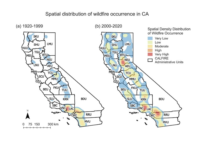
Researchers in the Department of Civil & Environmental Engineering at the University of California, Irvine have conducted a thorough analysis of California Department of Forestry and Fire Protection wildfire statistics from 2000 to 2019, comparing them with data from 1920 to 1999. They learned that the annual burn season has lengthened in the past two decades and that the yearly peak has shifted from August to July. The team's findings are the subject of a study published today in the open-access journal Nature Scientific Reports.
The study is a focused examination of fire frequency, burned area and myriad drivers of the catastrophically destructive events. The team found that the number of hot spots – places with severe fire risk – has grown significantly in recent years, fueled by higher annual mean temperatures, greater vapor pressure deficit (lack of air moisture), drought, and an elevated chance of blazes being sparked through such human causes as power line disruptions, construction, transportation, campfires, discarded cigarettes and fireworks.
“CALFIRE data show that each new year of the 21st century has been a record breaker in terms of wildfire damage in California,” said co-author Tirtha Banerjee, UCI assistant professor of civil & environmental engineering. “We also have seen that about 80 percent of the total number of the state's wildfires over the past few decades have been small, measuring less that 500 acres. But when fires get large, their deadliness greatly increases.”
Banerjee said that to gain a proper understanding of the growth of fire risk in California, it's important to put large and small incidents into separate buckets. By doing this, the team learned that 1,247 out of 6,336 wildfires, about 20 percent, accounted for 97 percent of the total burned area in the 2000 to 2020 period.
UCI civil & environmental engineering researchers conducted a thorough analysis of fire frequency, burned area and the many drivers of California's catastrophic wildfires, finding substantial growth in the number of fire risk hot spots throughout the state over the past two decades. Shu Li / UCI
“And more than nine-tenths of the casualties and property losses can be attributed to fires exceeding the 500-acre threshold,” Banerjee said.
He added that over the past two decades, there has been a significant increase in “extreme” wildfires scorching more than 10,000 acres. Coinciding with that has been a rapid uptick in the frequency of small, human-caused blazes.
One of the most alarming findings of the study, according to lead-author Shu Li, a Ph.D. student in Banerjee's laboratory, is the substantial spatial growth of fire risk throughout the state. From 1920 to 1999, California's only hot spot with “very high wildfire density” was Los Angeles County. In the past 20 years, that designation has expanded greatly in Southern California to include Ventura County, and portions of Riverside, San Diego and San Bernardino Counties.
Even in northern California, areas known by fire managers as the Nevada-Yuba-Placer Unit and the Tuolumne-Calaveras Unit are newly emerged as high-density wildfire regions.
“Before 2000, there were almost no human-caused wildfires along California's Pacific coastline, but now nearly every coastal county is experiencing increased risk, and the San Benito-Monterey Unit and the San Luis Obispo Unit have even become new hot spots,” said Li.
Many of the major fires in the northern part of the state are naturally occurring, predominantly ignited by lightning. But the majority of the increase in fire probability in recent years can be blamed on an expansion of the wilderness-urban interface. As people move into previously unpopulated areas, they bring their bad fire management habits with them.
“The concurrence of human-caused climate change, which is drying out our forests and grasslands and creating longer stretches of hot weather, and a steady influx of people into remote areas is creating conditions for the perfect fire storm,” said Banerjee. “But there is some good news in all of this; human-caused fire risk can be mitigated by better fire management practices by humans.”
He said he hoped the study and the near real-time analysis of fire risks in California's natural environment it provides can be used by government agencies and public policy officials to both prevent and combat costly blazes.
Funding for this research project was provided by the Henry Samueli School of Engineering at UCI and the UC Office of the President.
About the University of California, Irvine: Founded in 1965, UCI is the youngest member of the prestigious Association of American Universities and is ranked among the nation's top 10 public universities by U.S. News & World Report. The campus has produced three Nobel laureates and is known for its academic achievement, premier research, innovation and anteater mascot. Led by Chancellor Howard Gillman, UCI has more than 36,000 students and offers 224 degree programs. It's located in one of the world's safest and most economically vibrant communities and is Orange County's second-largest employer, contributing $7 billion annually to the local economy and $8 billion statewide. For more on UCI, visit www.uci.edu.
Media access: Radio programs/stations may, for a fee, use an on-campus ISDN line to interview UCI faculty and experts, subject to availability and university approval. For more UCI news, visit news.uci.edu. Additional resources for journalists may be found at communications.uci.edu/for-journalists.
Posted on
Monday, May 3, 2021 at
11:12 AM
Focus Area Tags: Environment
A team of California and Nevada fire scientists have produced a booklet with step-by-step guidance on retrofitting an existing home to be more resilient to fire.
Susie Kocher, UC Cooperative Extension forestry and natural resources advisor and co-author of the new guide, said some homeowners feel powerless to protect their homes against California's increasing wildfire threat.
“I'm happy to tell them that's not true. There are specific actions that we can all take to reduce the likelihood of our homes being burned in wildfire,” said Kocher, who lives in a forested area near Lake Tahoe. “We need to educate ourselves on the details of home construction that make homes less vulnerable to ignition.”
The free 20-page publication, How to Harden Homes against Wildfire (http://ucanr.edu/HomeRetrofitGuide) is now available online. It includes recommendations for 12 vulnerable components of homes in wildfire-prone areas, including roofs, gutters, vents, siding, windows, decks and fences.
In the past, agencies have focused on recommending changes in vegetation and establishing defensible space. However, Kocher said recent advances in wildfire science have exposed vulnerabilities of structures themselves.
“Managing vegetation and retrofitting the home are both needed to decrease wildfire risk and help our communities become more fire adapted,” she said.
CAL FIRE awarded funding to develop and publish the wildfire home retrofit guide, funding that is part of California Climate Investments, a statewide program that assigns cap-and-trade dollars to projects that aim to reduce greenhouse gas emissions, strengthen the economy and improve public health and the environment.
In addition to CAL FIRE, organizations that contributed to the document are University of Nevada, Reno Extension; University of California Cooperative Extension; Living with Fire, Tahoe; Tahoe Fire and Fuels Team; Tahoe Resource Conservation District; and Tahoe Network of Fire Adapted Communities.
The team also hosted three webinars to share home fire resilience information targeted to different audiences. Videos of the webinars are available on the Living with Fire YouTube Channel:
For the public: https://www.youtube.com/watch?v=YX114wpPwmg&t=327s
For building professionals: https://www.youtube.com/watch?v=ccIAIg6xONs
For fire educators: https://www.youtube.com/watch?v=lOsdyVSPxnA&t=177s
UC Agriculture and Natural Resources brings the power of UC to all 58 counties. Through research and Cooperative Extension in agriculture, natural resources, nutrition, economic and youth development, our mission is to improve the lives of all Californians. Learn more at ucanr.edu.
Posted on
Thursday, January 28, 2021 at
5:06 PM
- Author:
Jeannette Warnert
Focus Area Tags: Environment