Posts Tagged: weeds
Need Help Identifying Weeds?
After all the winter rains you may find yourself dealing with weeds and struggling to control them....
Bermuda Buttercup
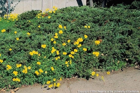
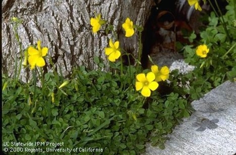
Bermuda buttercup (Oxalis pes-caprae) has become a tenacious and frustrating weed throughout California. From November through April, bright yellow flowers on leafless stalks and green shamrock-like leaves pop up in many of our landscapes. While it was brought from South Africa as an ornamental plant, it escaped cultivation on its route to being a chronic nuisance. It competes with other plants and is very difficult to control.
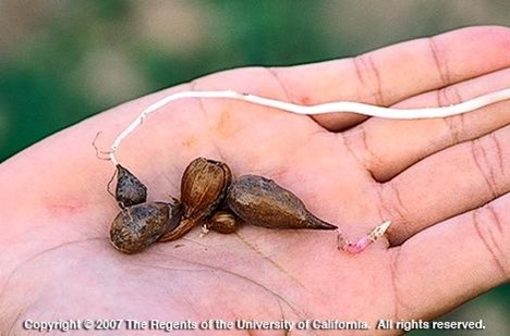
Bermuda buttercup develops from underground bulbs that produce a single vertical stem. A loose rosette of leaves will appear at soil level after the first rain. Small, whitish bulblets develop on the stem, and new bulbs form underground. Each plant can produce about a dozen small bulbs each year that easily detach from the plant and will increase the plant's spread quickly.
A couple of our favorite vertebrate pests (gophers and voles) consider oxalis bulbs to be a yummy food source and can spread the bulbs to new locations as they carry them back to their underground dens.
The best way to control Bermuda buttercup is to prevent its introduction into your garden. Don't move soil or plants from an infested site to another location that is free of the weed. Unfortunately, for many of us, it's too late for that tactic. So, what can we do when faced with the cheery yellow flowers popping up throughout the landscape?
Hand pulling can provide control if the entire plant is removed, including the underground rhizome and bulb. It's difficult to find all the bulbs without sifting the soil very carefully. Repeatedly removing the tops of the plants will eventually deplete the bulb's resources, but it can take years to be successful. It's important to remove the tops of the plants before they flower and form new bulbs.
It is difficult to smother Bermuda buttercup with thick mulch or even weed block cloth because it is a strong plant. If cardboard covered with a thick layer of mulch is used to try to smother the weed, continued vigilance in monitoring and pulling new growth will be needed in subsequent years. In one garden, weed cloth was laid under a brick walkway. The following winter, Bermuda buttercup pushed its way up through the weed cloth between the bricks. This made removing the plants even more difficult because the plants were being held in place by the weed cloth.
Several herbicides will effectively kill the tops of the plants, but will not kill the bulbs, so regrowth will occur.
Whatever method you choose to combat a Bermuda buttercup invasion, you will need to be persistent and prepared to continue in subsequent years.
For more information about managing Bermuda buttercup, see this web page: https://ipm.ucanr.edu/PMG/PESTNOTES/pn7444.html
Help Desk of the UC Master Gardeners of Contra Costa County (SEH)
oxylis2-468
oxalis corms
oxylis3
What Makes a Weed a Weed?
For many of us, gardening involves a constant battle with weeds. Basically, a weed is nothing...
Organic Tips
|
Google Weed View? Professor trains computer to spot invasive weed

Algorithm for AI enables low-cost tracking of invasive plant
To manage johnsongrass, a noxious weed that crowds out cotton and sickens horses, farmers have tried herbicides, burning and hand-pulling. Now, researchers at University of California, Davis, have developed a more high-tech weapon against the invasive weed: artificial intelligence and machine learning.
Using photos from Google's Street View database, UC Davis researchers have tracked down over 2,000 cases of johnsongrass in the Western United States for a fraction of the cost and time that it would take to do drive-by or other in-person surveys. They call their tool Google Weed View.
The advancement could help land managers easily and quickly survey for other problem plants.
“Once the model is trained, you can just go and run it on millions of images from Google Street View,” said Mohsen Mesgaran, an assistant professor in the Department of Plant Sciences at UC Davis. “We have huge flexibility, and its capability can be scaled up very quickly.”
The technique can easily be extended to other plant species. All that is needed is to label the new item in Street View photos and train the algorithm to identify that object in the images.
By providing location information, Google Weed View also offers an opportunity to examine how climate affects the growth and spread of weeds and invasive plants at very large scales.
“I think it can be both useful for management and for people with interests in more basic questions in ecology,” Mesgaran said.

A colleague's query
Mesgaran began looking at using Google's photo database of roadways, streets and highways after Kassim Al-Khatib, a professor of Cooperative Extension in the same department, asked if he could survey Western states for johnsongrass.
Al-Khatib studies where johnsongrass grows, ways to manage it and how this perennial has evolved to be so prevalent and resilient. He's also working with scientists at the University of Georgia to decode the genome of johnsongrass, which is one of the top 10 most invasive weeds worldwide.
Johnsongrass can crowd out native plants, harbor pathogens and affect agriculture. It grows up to 7 feet tall with flowers that are green, violet, dark red or purplish brown depending on maturity, according to a UC Statewide Integrated Pest Management Program briefing page.
“Johnsongrass is a major weed not just in California but worldwide,” Al-Khatib said. “It's very difficult to control. It's a problem on vineyards. It's a problem for cultivated crops. It's a problem on orchards.”
Google Weed View allows for rapid, convenient scanning. It is continuously updated via everyday users with compatible cameras and images collected by Google. “Instead of a day of in-person driving, we can use AI to determine if johnsongrass is in a county or not,” Al-Khatib said.

Setting the parameters
To find the weeds, Mesgaran went to Google Street View, which hosts billions of panoramic photos. It didn't take long to find johnsongrass.
“The pictures are really good quality,” he said. “You can see plants and flowers.”
Street View's photos offer a 360-degree view, so in his request Mesgaran set parameters, based on street direction (bearing), to only see the side view. He also specified latitude and longitude, and other factors. To train the deep, or machine learning model, he chose Texas, where johnsongrass is prevalent.
A student sorted through over 20,000 images from that request to find pictures with johnsongrass and drew rectangular shapes around the weeds. They located 1,000 images.
The labeled photos were fed into a computer to train a deep learning algorithm capable of identifying johnsongrass in Google's images. The model was run again to capture potentially more images containing johnsongrass. These additional images were then labeled and used to further refine the model. With each iteration, the algorithm learned and became more accurate.
“This deep learning model was trained by these images,” Mesgaran said. “Once we had a semi-working model, we ran it against about 300,000 images.”
For Al-Khatib's request, researchers focused on 84,000 miles of main roads in California, Nevada, Oregon and Washington states. The team discovered 2,000 locations with johnsongrass.
Google Weed View cost less than $2,000 to purchase the images and teach the model. A traditional car survey to cover the same area would cost an estimated $40,000 in gas, hotel, food and other costs.
“In a matter of months, we came up with 2,000 records and I can do it for the whole U.S.,” Mesgaran said.
Next up? The entire United States.
This story was originally published on the UC Davis College of Agricultural and Environmental Sciences news site.
