Posts Tagged: IGIS
DroneCamp is back!

June 24-28, 2024
CSU Monterey Bay
(plus virtual open)
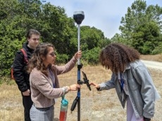
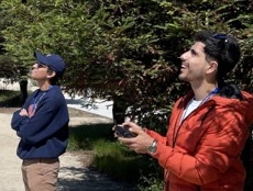
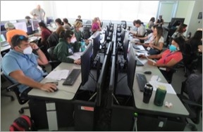
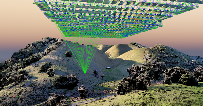
DroneCamp is a premiere five-day training program that covers everything you need to know to use drones for mapping and data collection.
Curriculum at a Glance
- equipment
- safety & regulations
- flight planning
- manual & autonomous flight
- photogrammetry
- hands-on data processing with Pix4D, OpenDroneMap & ArcGIS Pro
- data analysis & visualization
- research talks & use cases
- educator track - new for 2024!
Now in its eighth year, Drone Camp 2024 will once again provide a unique drone training opportunity designed for a wide range of skill levels and interests, from complete beginners with little to no experience in drone technology, to intermediate users who want to learn more advanced data processing and analysis.
DroneCamp started out as an IGIS workshop, but has evolved into a highly collaborative program with instructors coming from 8 campuses including UC ANR, UC Merced, UC Santa Cruz, CSU Monterey Bay, UC Davis, UC Berkeley, UC Santa Barbara, Lakeland College, and American River College.
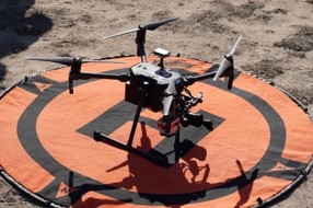
DroneCamp 2024 will be held in-person at CSU Monterey Bay June 24-28, 2024. Scholarships to cover the registration fee are available for all ANR academics and staff - but you must apply soon! More info available at DroneCampCA.org.
 |
 |
 |
 |
IGIS servers migrating to new data center week of Jan. 22
Some websites and services may be disrupted
The Informatics and Geographic Information System Program is pleased to share that beginning Jan. 22, its servers will be migrating to the new data center near Sacramento. As part of the move, our equipment is being upgraded to more stable and secure platforms. This initiative is a continuation of the UCANR systems upgrade that has been in the works for months and was initiated in December of last year.
The goal is to further optimize our infrastructure to provide you with improved services and performance. We are tremendously grateful and applaud the hard work of the Information Technology team and the vision of Sree Mada, our chief information officer, for spearheading this change.
The process is expected to take a week. Unfortunately, many of the websites and mapping services that IGIS hosts will be offline during this period. Impacted sites and services include:
- IGIS Website (custom scripts, content, and styles)
- Alameda County SALC Planning Decision Support Tool, Agricultural Resiliency Project, (ACARP) Alameda County RCD
- ANR Footprint App
- ArcGIS workshop license server
- Asian Citrus Psyllid monitoring web app
- Backyard Poultry Survey (UC Davis Vet Med, English and Spanish versions)
- CalAgroClimate
- California Heartbeat Initiative drone data repository, Natural Reserve System
- Climate Stewards Partners web app
- Coyote Cacher
- Degree Day API
- Oak Encroachment web app (Humboldt and Del Norte Counties)
- Parcel Prioritization Tool (Altamont Open Space Advisory Committee, Alameda County)
- San Diego County Agritourism web app
- UCANR Personnel Explorer (web app of Academics and Staff)
- UCANR REC Tour web app
- Wildfire Fuel Mapper Multi-Parcel Map Tool
- Wildfire Fuel Mapper (not affected)
We apologize for this temporary disruption. Rest assured our team is dedicated to minimizing any disruptions and ensuring a smooth transition. For any questions or concerns, please contact IGIS Service Center Head Shane Feirer at stfeirer@ucanr.edu.
Bountiful opportunities within ANR
Last week sped by in the blink of an eye. Monday Greg Ira and I attended the 7th Annual...
IGIS Joins UC Love Data Week 2022 - A Multi-Campus Workshop Series Focused on Data

Fortunately the tools of the trade are keeping up, allowing us to manage and utilize data more efficiently and effectively than ever before. And there's no better place to see what's out there than the annual UC Love Data Week, February 14-18, 2022.
UC Love Data Week is a week-long series of data themed workshops held annually around Valentines Day. This year, data scientists, librarians, and instructors from 9 of the ten UC Campuses are teaching workshops on a wide range of data topics. IGIS is pleased to represent UC ANR for the first time ever, joining the fray with two of our newer workshops on working with Cal-Adapt climate data in R (2/17/22) , and analyzing spatial data using Python Notebooks in ArcGIS Pro (2/18/22).
Other workshops this year run the gamut from data ethics and justice, to developing a data management plan for your proposal, to a data feminism book club meeting. And many others. All are free and open to all UC affiliates. Check out the complete offerings on the UC Love Data website.
Highlights from Google’s 2021 Geo for Good Summit
by Annie Taylor

If you attended any of the Google Earth Engine workshops I've led with IGIS, then you know that I love talking about the tool and hearing what others are doing with it. Last month, I attended my fifth Geo for Good Summit, which is quite possibly my favorite annual event. I'll provide a recap of the event and some of my highlights, and then links for you to check out the summit for yourself or explore other resources.
Google's Geo for Good Summit is an annual conference where folks from nonprofits, government agencies, and scientists hear about the latest updates to Google's mapping tools and get to share their work with each other. Geo for Good, also abbreviated as G4G, has been held since 2012 and was an in-person Bay Area conference until 2020, when it was first held virtually. G4G continued in that virtual format in 2021, with some exciting twists on the usual virtual format.
G4G always kicks off with an inspiring community video that showcases different people and use cases, and this year was no exception.
Next, we got updates on the latest improvements to Google's geospatial tools, which is my personal favorite session. Here's a rough summary of my highlights.
What's new in Google Earth?
In case you haven't heard, Google Earth is now a gorgeous web application. Google Earth Pro (the desktop application) is still supported as they migrate all of its tools and functionality to the web version. There's also a mobile application for your phone! These updates relate to the web application:
- You can now export tile overlays from EE and import them into Earth so that they drape on top of the 3D planet – very cool visualization for your data.
- You can collaborate on Earth projects just like you would a Google Doc using the Cloud Project option.
- The date of the basemap imagery (when available) now pops up when you move your cursor. Also, the scale bar shows the scale bar relative to where your cursor is, which is a great addition for 3D viewing.
What's new in Earth Engine?
- Landsat and Sentinel images are now ingested and loaded into EE in under 12 hours from their capture – enabling near real time analysis in EE.
- The Dynamic World dataset – a global land cover probability map at 10m resolution available every five days from 2017 to 2021 – will soon be available in the EE Data Catalog.
- Additions to the API (new machine learning models)
- Additions to the Data Catalog and more Python API example scripts
Other Geospatial Tools by Google
I won't go into these here, so check out the recorded sessions for more information:
- Google My Maps
- Google Earth Studio
- Google Street View and Maps API
G4G was very creative in their approach to the virtual conference. For example, they organized poster sessions and virtual mingling in a custom space they created using Gather, where you could see and hear the people ‘nearest' to you in the ‘room.' They also hosted user-created Meet Ups, where members of the community can break off to talk about their specific application, tool, or part of the world. A final highlight of the conference were the Office Hours hosted by the engineers working on each of these tools, which is an incredible opportunity to talk through your specific idea or challenge.
If you missed it, you can find all of the recorded sessions on the conference website or on Google Earth Outreach's YouTube site, which are both linked below.
I hope to see you next fall at G4G 2022!
Annie

Conference Website (with recordings)
Geo for Good YouTube Channel Playlist
Earth and Earth Engine Blog
