Posts Tagged: Rob York
Lessons on wildfire resilience from a 4,000-acre forest lab
Reposted from the UC Berkeley News In his years managing California woodlands, Rob York has...
Lessons on wildfire resilience from a 4,000-acre forest lab
In his years managing California woodlands, Rob York has come up with a few quick and easy ways to gauge whether a forest is prepared for wildfire.
“The first question I like to ask is, ‘Can you run through the forest?'” York says.
York, an assistant cooperative extension specialist and adjunct associate professor of forestry at UC Berkeley, poses the question while standing in a grove of pine trees during a tour of Blodgett Forest Research Station, a 4,000-acre experimental forest in the northern Sierra Nevada. While fire suppression has allowed many of California's forests to grow thick and dense, this patch of forest is one you could actually run through: The area is punctuated by large trees spaced a few meters apart, separated by a smooth carpet of dried pine needles.
“The idea is, if it doesn't have a lot of buildup of surface fuel on the ground — sticks and logs — you should be able to run through it,” York adds. “Looking through this forest, I might have to jump over that log, but, generally, I could take a jog through it.”
For more than 50 years, York and other Berkeley forestry researchers have used Blodgett as a living laboratory to study how different land management treatments — including prescribed burning, restoration thinning and timber harvesting — can reduce the risk of severe wildfire and improve a forest's resilience to the impacts of climate change. In addition to research, Blodgett regularly hosts workshops to demonstrate different land management techniques to landowners.
After another year of record-breaking wildfires in California, the work at Blodgett is more critical than ever, and state and federal agencies are motivated to enact more effective forest management practices. In 2020, the state and the U.S. National Forest Service jointly committed to managing 1 million acres of California forests a year, and last month the Biden administration pledged billions in new federal funding to reduce wildfire risk in the state.
“[Blodgett] was really designed to eventually demonstrate land management alternatives and offer a glimpse into how they might look at bigger scales,” York said.

Experimenting with fire
Blodgett Forest is “pretty representative of millions of acres of Sierra mixed conifer forest,” said Ariel Roughton, a research stations manager at Berkeley Forests. After the majority of its trees were logged in the early 1900s, the forest was donated to Berkeley in the 1930s with the intent that it would be used to study sustainable timber production. Aside from a few old relics that survived early logging, the majority of the trees are regrowth and approximately 100 years old.

“Back then, people thought, ‘Why would you ever want to use fire for land management?' They wanted to grow trees, they want to grow timber. The idea of seeing black and char was literally off the scale,” said Scott Stephens, a professor of forest science and co-director of Berkeley Forests. “It's amazing that just a few decades ago, researchers didn't have the opportunity to do the work that Rob and Ariel and others are doing up here now.”
In the open, airy tract of forest that York could easily jog through, blackened scorch marks extend 10 to 15 feet up the trunk of each tree. Ecologists believe that before European colonization, these forests experienced fire once every 10 years or less, leading to open forest structures very similar to this one. Here, two years ago, Roughton, York and their colleagues conducted a prescribed burn to remove excess fuel from the ground and reduce the risk of wildfire.
“I think it's important to remember that nature hasn't taken its course without a lot of human intervention since the last glaciation, because there was strong Indigenous burning here,” said John Battles, a professor of forest ecology at Berkeley. “There has always been intense human stewardship of one sort or another.”

While there are forest management strategies that can be effective on a shorter time scale, it usually takes at least a few separate treatments over the course of a few years to successfully restore a forest and reduce its wildfire risk, York explains.
“It can be a challenge to get to the forest structure that we want,” York says. “It takes a lot of time, and it takes a lot of investment.”
Climate change is also narrowing the annual windows of time when conditions are best for prescribed burning, limiting when and how often foresters can safely burn. Hot, dry conditions usually make prescribed burning too risky during the summer, while rain and snow in the winter can leave the forest too wet and damp for fire to burn. However, research at Blodgett is showing that, with the right management decisions, prescribed burning during the winter can be made more viable.
“Because of timber harvests that removed some of the canopy and subsequent treatments to remove the ladder fuel, we now have more light hitting the ground, and it dries out faster,” Roughton said. “We've gotten to the point out here where we're able to burn more easily because of our past management actions.”

Friends of the forest
While York likes to imagine running through the trees, Battles has a slightly different metric for evaluating the health of a forest.
“You need to be able to run through the woods,” Battles said. “But I also want to see all six of my friends as I do my run.”
Battles' friends are the six tree species that make up the Sierra mixed conifer forest: oak, ponderosa pine, sugar pine, white fir, Douglas fir and incense cedar. Fire suppression — and the dense, overgrown forest structures that can result — often favor the survival of some of these species over others, leading to forests that are dominated by just one or two species. This lack of biodiversity can make the forest, as a whole, less resilient to stressors like bark beetles or tree pathogens, which often target some of these species, but not others.
According to Battles, the open structure and frequent fire at this tract of Blodgett has allowed all six of his friends to flourish.
“I see my friend, ponderosa pine, which you don't see as frequently in the unburned forest because it's shade intolerant — it needs light. I see oak, and it also requires fire to get a lot of the oaks,” Battles said. “I see all six of my friends all here, and you only see them when you have management like this.”
Over the past 20 years, research has shown that prescribed burning and mechanical thinning with tools like the masticator can also benefit soil quality and water availability, while having no significantly negative impacts on forest ecosystems. While burning or otherwise removing plants and trees can release carbon dioxide into the atmosphere, which accelerates the impacts of climate change, reducing the risk of severe wildfire can help maintain the whole forest for long-term carbon storage.
However, applying these techniques across 33 million acres of California forestland remains a monumental task. Prescribed burning requires a great deal of expertise and is also limited by weather conditions and air quality regulations. Meanwhile, mechanical tree thinning can be costly, and unlike timber harvesting, it does not generate any revenue for landowners — though Berkeley researchers have suggested that creating a market for small trees and other woody biomass could help offset the cost while limiting carbon emissions.
“Fire used to be so common in this system, and that's no different than in most forests in California. But, when you take it out for that long, you begin this transformation,” Stephens said. “That's why we have to get both public and private entities together to come up with a philosophy to be able to move forward on this. Blodgett is 4,000 acres — that's interesting, but it doesn't really address the needs of the state. We always hope that our work shows people what's possible and then enables them to continue it.”

Just what is a ‘resilient’ forest, anyway?
Reposted from UC ANR news Study finds resilient, frequent-fire forests have...
UCLA Engineering Student Uses Drone Sensing in Prescribed Burns to Prevent Wildfires
Reposted from UCLA Samueli Engineering Newsroom
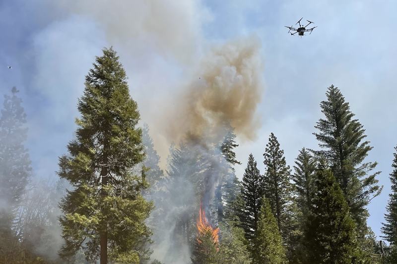
Drone sensors for deployment into a local ignition event Courtesy of Kevin Schwarm
Using new drone sensing technology, Schwarm has helped contribute to a new way of measuring the emissions of fires — carbon monoxide, carbon dioxide, particulates, volatile organic compounds, etc. — so researchers can gain a deeper understanding of the way wildfires behave.
When controlled properly, the so-called prescribed burns — fires that are intentionally set to clear out vegetation that otherwise could end up fueling larger, more catastrophic fires — can play a key role in maintaining the health of a forest. They help prevent the kinds of wildfires that have wiped out homes and caused devastating losses of lives across California in recent years.
Since the Gold Rush, however, the amount of plant life in forests in California has proliferated. While this growth is ostensibly good for the health of the forests, the extra vegetation actually increases the risk of extreme wildfires as it provides large amounts of fuel.
Located about 142 miles east of UC Berkeley on the western slope of the central Sierra Nevada, the 4,400-acre Blodgett Forest Research Station has been a living laboratory since 1933. In April, Rob York, an assistant Cooperative Extension specialist and adjunct associate professor of forestry at UC Berkeley, directed a field campaign involving four days of controlled burns. Scientists and forestry experts from other universities, including UCLA and UC Riverside, joined in the effort to reduce wildfire risk.
Working with engineers from OptoKnowledge, Schwarm was a part of several research teams in charge of measuring the emissions of the prescribed burns. They monitored the emissions using a drone that features on-board, optical sensors that can measure levels of airborne carbon monoxide and carbon dioxide. The team also used the data to create aerial maps that correlate the emissions with the fires, as well as other ground and air measurements.
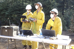
Schwarm, whose doctoral research focuses on optical diagnostics for combustion systems and harsh environments, was responsible for monitoring the data collection, working with the optical sensor equipment and guiding the drone pilots during the tests.
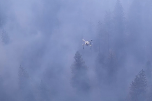
at Blodgett Forest
A Maine native who loves the outdoors, Schwarm was initially interested in research involving internal combustion engines when he first visited UCLA in 2017 as a prospective graduate student. After meeting Spearrin and learning about his research on laser diagnostics and combustion systems, Schwarm was intrigued and decided to join Spearrin's research group that fall.
“I found Professor Spearrin's research very compelling, with laser diagnostics providing an avenue for engine research while also remaining an elegantly simple yet powerful measurement tool with wide applicability,” Schwarm shared.
Last fall, Spearrin introduced Schwarm to the multicampus wildfire project. “I found it a very exciting opportunity to use our expertise in combustion diagnostics to play a role in enhancing our understanding of both wildfires and climate change, which could lead to better methods for managing these grave issues,” Schwarm said.
According to Schwarm, the preliminary results from emissions data collected during the field campaign indicate that the drone sensor was very effective in capturing the multi-dimensional gradients of emissions in the fire plumes.
The team has been able to create three-dimensional spatial maps of the emissions concentrations, tracking how they change over time. This finding provides the researchers with insight into how fires behave, such as where the boundaries of the fire are and where new ignition sites emerge.
“This is very exciting as a new sensor capability to provide a deeper level of information for a wide range of applications in wildfire science and management, and we are currently working with the other researchers involved in the burns to place that information into context,” Schwarm said. “This was the first full-scale, real-world test for our drone sensor, and it will serve as a strong foundation for future deployment and expansion of our methods.”
Sara Hubbard contributed to this story.
To reduce wildfire risk, forestland owners can do winter controlled burns, says UCCE expert
Reposted from the UC ANR news
When conditions are right, winter can be a good time to conduct prescribed burns for forest management, says Rob York, UC Cooperative Extension forestry specialist.
“A huge issue we have in California is fire severity. We know from research that prescribed fire can be a very good tool for reducing fire severity,” York said. “For forest landowners or foresters who want to do their own prescribed burning, winter burning can be a good entry point.”
York is based at the UC Blodgett Forest Research Station in Georgetown, where he developed a series of eight short videos demonstrating how fire can be used on landscapes during the colder months. The videos feature controlled fires conducted at the station on Dec. 6 and 9, 2020. More videos in this series will be posted during the upcoming year.

Among the factors covered in the videos are climatic conditions and site selection for winter burning.
Climatic conditions
Wet or snowy weather in the fall may seem to shut the window for prescribed burning, but York said often the snow melts away and fuels dry out enough to do a winter burn.
“The idea is to be ready when the fuels dry out,” he said. Thinning trees and masticating underbrush are ways to prepare the forest for a burn.
When selecting the day of the fire, relative humidity, temperature and wind speed and direction are important considerations.
“Relative humidity should be low. You want the cloud cover to be very low. A sunny day helps dry out the fuel,” York said. “In the winter, you want that drying and heating power of the sun to help the fuel be consumed.”
Site selection
Among the factors to consider in selecting locations for winter burns is the aspect. The sun's warmth is optimized on south-facing slopes.
“That's what we're looking for,” York said. “Relatively small areas that are burnable.”
An open canopy allows sunlight to dry out the understory vegetation and surface fuels, enabling successful winter burns.
Vegetation type also weighs into winter burning decisions.
“Bear clover plus pine needles make this feasible, including conditions on the wetter side when you might not otherwise be able to burn, you can burn,” York said. “If you can encourage bear clover and pine needles, you can encourage more opportunities for low density burns, which I think do a great job to maintain low fire hazard.”
Find the complete series on the UC Forestry and Range YouTube channel (https://www.youtube.com/user/UCExtensionForestry) in the playlist titled Winter Prescribed Burning.
UC Agriculture and Natural Resources brings the power of UC to all 58 counties. Through research and Cooperative Extension in agriculture, natural resources, nutrition, economic and youth development, our mission is to improve the lives of all Californians. Learn more at ucanr.edu.
