Scientists collect data about a year after the 2016 Cedar Fire. (R. Wayman/UC Davis)
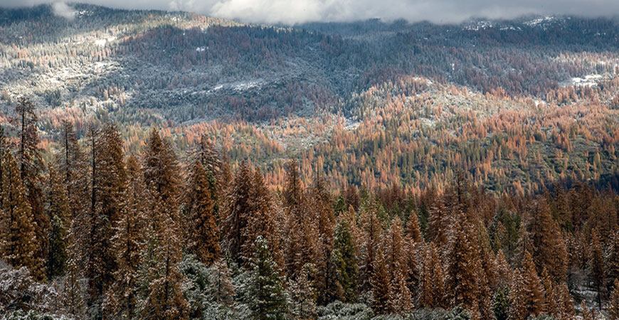
California's drought of 2012-2016 killed millions of trees in the Sierra Nevada — mostly by way of a bark beetle epidemic — leaving a forest canopy full of dry needles. A study published from the University of California, Davis, and the U.S. Forest Service helps answer concerns about what effect dense, dead foliage could have on subsequent wildfires and their burn severity.
In the study, published in the journal Ecological Applications, scientists found that the presence of recently dead trees on the landscape was a driver of wildfire severity for two large fires that occurred toward the end of the drought: the 151,000-acre Rough Fire in 2015 and the 29,300-acre Cedar Fire in 2016.
The publication is the first field-based study to document the important role recently dead trees can play in exacerbating fire severity in California forests that are historically adapted to frequent, low-severity fire.
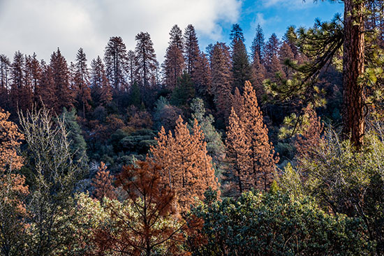
Tree mortality is evident within the 2015 Rough Fire footprint in April 2016. ((c) R. Wayman/UC Davis)
Climate change and forest management
The study highlights the importance of forest fuels, in addition to climate change, as a strong driver of fire severity in Sierra Nevada forests.
“We've long known that both fire weather and forest fuels can influence wildfires, but it was unclear whether recently dead trees would change conditions enough to alter fire severity,” said lead author Rebecca Wayman, an associate specialist of forest and fire ecology in the UC Davis Department of Environmental Science and Policy. “We found that the dead trees did increase fire severity, even though these fire-suppressed forests were already at risk of unnaturally severe wildfire prior to the drought.”
It wasn't drought alone that killed millions of trees, Wayman noted. A prolonged, hot drought hit forests that were overly dense and water-stressed due to more than a century of excluding wildfire and Indigenous fire from the landscape. This resulted in a bark beetle outbreak that was unprecedented in the Sierra Nevada.
Fortunately, the same strategies commonly used to reduce the risk of catastrophic wildfire — thinning and prescribed fire — also can reduce the severity of future bark beetle epidemics.
“It's a win-win to restore forests to healthier, less-dense conditions, especially as they face hotter and drier climate conditions that promote both wildfire and bark beetle attacks,” Wayman said.
Disturbance brings shifts
For the study, the researchers collected data on 180 plots within the Rough Fire and Cedar Fire footprints, located in the Sierra and Sequoia national forests, and the Giant Sequoia National Monument. It identified pre-fire tree mortality as influential on all measures of wildfire severity on the Cedar Fire, and on two of three measures on the Rough Fire. For the Rough Fire, it was the most important predictor of trees killed by fire. For the Cedar Fire, weather conditions during burning had the strongest influence on fire severity.
The dual disturbances also shifted the pine-dominated system of the Rough Fire study area to a cedar/pine/fir system, which is less well-adapted to wildfire. Dominant species remained unchanged in the area affected by the Cedar Fire, which was already dominated by fire-sensitive species.
Pre-fire tree mortality may have a greater influence on fire when weather conditions are mild compared to when high temperatures, low relative humidity and high winds can drive extreme wildfire behavior, the study indicated.
“The question of how two profound disturbances — drought and fire — interact to affect California forests is an important one,” said co-author Hugh Safford, regional ecologist for the USDA Forest Service's Pacific Southwest Region and an adjunct member of the research faculty at UC Davis. “Current and projected future trends suggest that this sort of double-whammy will become more and more common as the 21st century progresses and the climate continues to warm. Our study helps us better understand how California forests are impacted by two extreme events in close proximity in time and how we might change these impacts with proactive management.”
The study was funded by the USDA Forest Service Pacific Southwest Region.
Media contact(s)
Rebecca Wayman, Environmental Science and Policy, 530-401-0471, rbwayman@ucdavis.edu
Kat Kerlin, News and Media Relations, 530-752-7704, 530-750-9195, kekerlin@ucdavis.edu
In 2020, 9,000 fires scorched more than 4 million acres of California, a record-breaking year, reported Alejandra Borunda in National Geographic. Fires burned through homes and oak forests, grasslands and pines — and also through patches of giant sequoias and coast redwoods, respectively the most massive and the tallest trees on earth.
Giant sequoias are not the oldest living trees, but some have been growing in Sierra Nevada forests for more than 3,200 years. They are found in 68 groves on the Sierra's western flank. The state's redwood forests grow in a narrow strip along the coast of Northern California and Southern Oregon.
The 2020 fires burned through about 16,000 acres of sequoia groves, about a third of their total area. In redwood forests of the Santa Cruz Mountains, 40,000 acres burned.
But because redwoods are well-adapted to fire, they'll likely recover pretty quickly, said Scott Stephens, a UC Berkeley fire scientist. “In some ways, this fire could make redwoods more dominant in the landscape," he said, because other trees — like the hardwoods or Douglas firs that crowded the local forests — died outright in the burns.
However, scientists are concerned one cause of the fires, climate change, could have additional impacts on these natural treasures.
Since the mid-1800s, temperatures in the western U.S. have increased by 1.6 degrees Fahrenheit. Fog banks are fading in coast redwood territory, and snows are less consistent in the Sierras. The changes leave redwoods and sequoias without their preferred climate conditions.
The most responsible thing to do now, Stephens said, is to “take the opportunity that has been handed to us,” and make a plan to go back in and burn again—soon, within the next few years.
UC Cooperative Extension forestry advisor Lenya Quinn-Davidson agrees that California must manage fire to help the trees survive. Tree-ring records show that humans have influenced the fire regime for better and worse as long as they've been in these forests.
“The empowering message there is, human management can actually override the effects of climate in a fire contest,” Quinn-Davidson said. “It's not just a climate story. We can't just throw in the towel, feel overwhelmed, and tell ourselves these trees are done for. That's not true!”
The massive die-off of conifers in the Sierra Nevada between 2012 and 2018 was predictable and unprecedented. Sadly, it is also likely to happen again, said UC Cooperative Extension forestry advisor Susie Kocher.
To help landowners manage forests in a way that minimizes the risk of such catastrophic tree die-off and the threat of uncontrolled wildfire, Kocher and two colleagues produced a 20-page publication that summarizes current research on tree mortality and outlines actions that can be taken to make the forest more resilient. The publication, Mass Tree Mortality, Fuels, and Fire: A Guide for Sierra Nevada Forest Landowners, is available for free download from the UC Agriculture and Natural Resources catalog.
Written by Stanford graduate student Devin McMahon (now graduated), UC Berkeley Cooperative Extension forest health specialist Jodi Axelson and Kocher, the publication presents the extent of the die-off in the Sierra Nevada, and describes different factors that contributed to the vast loss of tree life – including land management practices, weather patterns and geography. It includes detailed reporting on the mortality's impacts on fuels and fire risk so landowners and managers can understand and develop strategies to prevent similar destruction in the future.
While about two-thirds of California's 100 million acres of forests are public lands held by state and federal government agencies, the rest is in private hands. Large companies manage millions of acres for commercial timber production, but about 9 million acres are owned by individuals. Nearly 90% of individuals own 50 acres or less; 87,000 landowners have 10 acres or more of forest.
“That's a really large number of people,” Kocher said. “That's one of the reasons why it is so difficult for landowners to manage land to improve forest health and reduce fire risk. It's not economical to do forest management on small areas.”
It's also very complicated. As natural processes play out over time in a forest with mass mortality, the fire risk changes dramatically.
“In the new publication, we help people understand the nuances of forest management so they understand what actions are most appropriate throughout the whole cycle,” she said.
The publication provides an overview of fire risk reduction. A table lays out the seven components of fire risk – fuel load, fuel moisture, fuel continuity, probability of ignition, weather conditions, topography and vulnerability to fire – along with mitigation actions for each that landowners can take.
Intentional, controlled burning, or prescribed fire, is often the most effective way to decrease fuel loads and future risk from fires, the researchers wrote. Other management actions include masticating – chewing up brush and branches with specialized equipment – felling and removing dying and dead standing trees, and thinning live trees.
The authors conclude with a glimmer of hope for the future of California forest lands. “Carefully planned forest management can reduce the amount and continuity of fuel on the landscape and limit the risk of destructive fire after tree mortality.”
The scope of the tree deaths is evident when viewed as part of the larger forest.
The most extreme drought event in hundreds of years caused a catastrophic die-off of the Sierra Nevada's mature trees in 2015-2016.
A study published today in Nature Geoscience details how UC Merced Professor Roger Bales and his colleague Professor Michael Goulden from UC Irvine tracked the progress of the devastation caused by years of dry conditions combined with abnormally warm temperatures.
The researchers warn that matters are expected to get worse as global mean temperatures increase.
“Parts of the Sierra Nevada reached a ‘tipping point' in 2015, where annual precipitation plus stored subsurface water were not enough to meet the water demand of the forest,” Bales said.
The trees in California's mixed-conifer mountain forests have roots that can draw water from as deep as 5 to 15 meters down, which has historically protected the trees against even the worst multi-year droughts.
But the severity of California's 2012-2015 dry-spell “exceeded this safety margin,” the researchers said. When forest stands exhausted the subsurface moisture, they became vulnerable to attack by pests, leading to widespread tree death.
From 2012 to 2015, the entire state experienced a crippling drought, but it was especially severe in the southern Sierra Nevada. The four-year period was the driest in the past century, combined with below-average precipitation and above-average warmth extending year after year.
“This forest die-off can be viewed as a ‘perfect storm' — the intersection of four years of low precipitation, hotter temperatures than in past droughts, and a heavily overstocked forest from centuries of fire suppression,” Bales said.
Trees faced an epic drought from 2012 through 2015, which scientists say will happen more frequently as the climate warms.
The research was supported by National Science Foundation and the U.S. Department of Agriculture. Observations by the U.S. Forest Service Aerial Detection Survey showed that many tree stands suffered complete loss of mature conifers. Pines were especially hard hit by an infestation of bark beetles.
Sierra Nevada Research Institute Director Bales, Distinguished Professor of Engineering with the Department of Civil and Environmental Engineering in the School of Engineering, and Earth System Science Professor Goulden examined tree communities at a variety of elevations and latitudes in the sprawling mountain range using field and remote-sensing observations.
A post-drought survey found that tree mortality was greatest near 3,800 feet of elevation, with nearly 80 percent loss in 2016.
The study outlines a key factor in the die-off: A period of unusually dense vegetation coinciding with a prolonged drought and warmer-than-usual temperatures. The heat and proximity of trees and plants to one another caused accelerated evapotranspiration — moisture evaporating from leaves and rising up in the sky as water vapor. This caused the trees to draw even more water from the ground.
“We expect climate change to further amplify evapotranspiration and ground moisture overdraft (when more water is taken out of the soil than is replaced by precipitation) during drought,” Goulden said. “This effect could result in a 15 percent to 20 percent increase in tree death for each additional degree of warming.”
With their improved understanding of the contributions of factors such as elevation, vegetation density, heat, precipitation and soil water amounts, the researchers said they now have a framework to diagnose and predict forest die-offs brought on by drought.
“Using readily available data, we can now predict where in mountain forests multi-year droughts are likely to have the greatest impact, and the threshold at which those impacts are expected to occur,” Bales said.
The dry Santa Clara River means that water needs are met by using subsurface groundwater.
Photo Credit: JOHN STELLA
Michael Singer
Riparian forests — the ribbons of trees that grow along river channels — play an important ecological role as refuges for endangered species in dry areas. But these natural havens are increasingly threatened by the changing frequency and intensity of drought, both of which are byproducts of climate change.
Scientists at UC Santa Barbara are studying how riparian forests respond to climate change that manifests as hotter and drier conditions over time. With $2.5 million in combined funding from three grants, Michael Singer, a researcher with UCSB's Earth Research Institute (ERI), and colleagues seek to understand the impact of nonstationary climate — trends in temperatures and precipitation — on riparian forests.
“As a river starts drying up, groundwater-dependent trees like those in a riparian forest might disappear, or the moisture within the soil might dry up, affecting more shallowly rooted trees and shrubs,” explained Singer, who also is a lecturer at Cardiff University in the United Kingdom.
Through the National Science Foundation's Geography and Spatial Sciences Program, one project — led by associate professor John Stella of the State University of New York College of Environmental Science and Forestry (SUNY-ESF) — is being conducted near UCSB in Ventura County's Santa Clara River Valley. A basin with competing water needs — ecological, urban and agricultural — the Santa Clara, because it goes dry, relies largely on subsurface groundwater. Continual pumping of groundwater from the aquifer for agriculture, when that aquifer is not recharged by rainfall, causes wells to go dry and forces pumping efforts to reach deeper and deeper.
Innovative new legislation in California, the Sustainable Groundwater Management Act (SGMA), shifts the management of groundwater resources from the state to local basins, requiring regional stakeholders to create action plans for managing water resources. With the grant, Singer and Stella will collaborate with UCSB geography professor Dar Roberts and The Nature Conservancy to develop an improved understanding of forest health along the Santa Clara River. They'll investigate matters including what happens to trees that are rooted at depths below the surface with diminishing groundwater, and their findings can be used to administer SGMA.
Through another NSF grant, in its Hydrologic Sciences Program, Singer, Stella and ERI director Kelly Caylor, also a professor in UCSB's Bren School of Environmental Science & Management, will study riparian forests along a major European river. The Rhône, which flows through France from Lake Geneva to the Mediterranean Sea, warms 2 degrees Celsius along its climate gradient. The researchers plan to measure the variation in temperature, precipitation and climate to model what might happen under climate change and determine how water availability to forests shifts due to climate and how trees are using water, as well as their corresponding growth and health outcomes over time.
The scientists also will core trees to determine their age and will extract cellulose from individual rings for isotopic analysis. Oxygen isotopes are used to distinguish water sources such as groundwater or rainfall, while carbon isotopes reveal how efficiently trees are using that water — a calculation of photosynthesis versus water loss.
The third project is funded by the Department of Defense through the Strategic Environmental Research and Development Program. Singer, Stella, Roberts and Caylor will develop a toolkit and provide quantitative support for land and water conservation management to promote the sustainability and resilience of riparian forest ecosystems located on DOD lands. The endeavor focuses on three dry area bases in drought-prone regions: Vandenberg Air Force Base near Lompoc; Marine Corps Base Camp Pendleton in San Diego County; and the driest, U.S. Army Fort Huachuca in southeastern Arizona.
“In all of these studies, we're developing water stress indicators, which can be physical manifestations such as dropping leaves or branches or trees becoming less green,” Singer explained. “Such markers can be seen in remote sensing imagery and tree-ring isotopes, but we're also looking at climate records for precipitation and temperature, along with numerical modeling to determine what type and how much water has been delivered to a basin in the first place. If we see trends that tell us the forest is really suffering, we hope to establish an early warning response window in which managers can act quickly before important patches of forests are lost.
“Combined, those various metrics give us a good idea of how well trees are doing,” Singer added. “We hope to integrate the results of these projects to eventually predict the thresholds of species collapse and perhaps even forest collapse. If we can identify what the dominant controls on those thresholds are climatically, we may be able to assess whether trends in temperature are more relevant than those for precipitation.”
")

")
")
")
")


