- Author: Pamela S Kan-Rice
GIS (Geographic Information Systems) Day is Nov. 20. To celebrate, the Informatics and GIS Statewide Program is highlighting how story maps are increasingly being used in UC ANR. Instead of going through the traditional route of trying to embed multiple photographs, screenshots, charts and tables in a single Word document, more ANR program teams and UCCE offices are finding creative ways to use story maps.
“Story maps are fun and easy to build, and can help program teams and UCCE offices communicate the work they are doing,” said Andy Lyons, IGIS program coordinator.
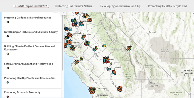
CE Offices across the state have come up with creative ways to use story maps to educate their clientele and spice up their annual report. Statewide Programs such as Environmental Stewards are also using story maps for technical training. Still other projects are using story maps to communicate their impact related to climate smart agriculture or California rangelands. To find examples of how story maps are being used within UC ANR and inspire more users in the ANR community, IGIS has built a story map collection.
RECs are also getting in on the action. Adina Merenlender, UC Cooperative Extension specialist in conservation science, used a story map to create the Hopland Research and Extension Center Land History.
“We wanted to share the land history of HREC on the REC webpage in an engaging way and take advantage of different types of content including photos, timelines and text,” said Merenlender. "It's been great to be able to share the land history of HREC including information about the Indigenous people, injustices and traumas tied to the area's colonial past and recognize the resilience and value of the Hopland Band of Pomo Indians.”
Story maps are a great way to tell your story using visually engaging content and narratives. They allow you to embed web-maps, high-resolution photos, dashboards and videos from YouTube, among other things.
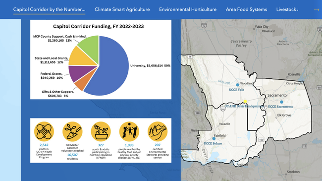
"Story maps have proven to be a fantastic tool with an easy learning curve, making it accessible and straightforward to use,” said Nicholle Stein-Peterson, who created the UCCE Capital Corridor Annual Report Story Map. “Moving away from the typical multi-page PDF was a refreshing change, and it made the process even more enjoyable. The enthusiastic feedback we've received has been truly motivating. I loved how, with minimal customization options, it allowed our annual report to look consistently polished and aligned with our brand.”
“The UC ANR Impact Story Map is a compilation of UCCE measured condition changes to help advance our efforts on measuring and communicating public value impact,” said Christina Becker, program policy analyst for Program Planning and Evaluation.
IGIS will offer an Intro to Story Maps workshop on Jan. 24, 2025. For more information, or to discuss an idea for a story map, contact Priyanka Vyas, GIS analyst, at pdvyas@ucanr.edu.
- Author: Pamela Kan-Rice
The Informatics and Geographic Information System Program has announced its Fall 2023 Workshop Schedule. All workshops will be on Zoom and are free for the UC ANR community.
Workshops include
- Intro to ArcGIS Online on Friday, Sept. 22, 1-4 p.m.
- Intro to R Wednesdays workshop series Sept. 27, Oct. 4, 11 and 18 at 10 a.m.-noon
- Intro to ArcGIS Pro on Friday, Oct. 13, 1-4 p.m.
- Intro to Jupyter Notebooks in ArcGIS Pro on Friday, Nov. 17
- Intro to ArcGIS Story Maps on Friday, Dec. 15, 1-4 p.m.
Unfortunately ArcGIS Pro doesn't run on Macs, however ArcGIS Online and ArcGIS Story Maps only require a browser. Mac users can still take the ArcGIS Pro workshop because the training will use a virtual machine that runs in a browser. After the workshop, Mac users will need to find another way to run it. Details and registration for the ArcGIS Pro workshop are at https://igis.ucanr.edu/Training/IntroArcPro_Oct_13_2023.
- Author: Pamela Kan-Rice

Workshops include “Introduction to ArcGIS Pro” (Feb. 17, 1-4 p.m.), and “Introduction to Jupytr Notebooks in ArcGIS Pro” (April 7, 1-4 p.m.). Registration will also be opening soon for DroneCamp 2023 (June 26-30) – your one-stop-shop for training on using drones for research and data collection. For complete details, see the IGIS website.
Registration is also open for nearly two dozen workshops being held as part of UC Love Data Week (Feb. 13-17). Hosted by all 10 campuses as well as UC ANR, LDW workshops cover a range of data-related topics including access, analysis, visualization, management, security, sharing and preservation. Whether you work with qualitative or quantitative data, you'll definitely find something of interest! Sign up soon as many of the workshops are likely to reach capacity.
- Author: Pamela Kan-Rice
The Informatics and GIS (IGIS) Statewide Program has announced their fall 2022 workshop schedule.
All workshops will be on Zoom and are free for the UC ANR community.
Workshops include
- Introduction to ArcGIS Online – Fri 9/30 1-4 p.m.
- Intro to R 3-part series – Part 1 Tues 10/11, 3:30-5 p.m.; Part 2 Wed 10/12, 3:30-5 p.m.; Part 3 Fri 10/14, 10:30 a.m.-12 p.m.
- Introduction to ArcGIS Pro – Fri 10/21, 1-4 p.m.
- Introduction to ArcGIS Field Maps – Fri 11/18, 1-4 p.m.
- Computing Agroclimate Metrics in R – Fri 12/2, 11 a.m.-12:30 p.m.
- Introduction to ArcGIS Story Maps – Fri 12/9, 1-4 p.m.
For details about these workshops, see the IGIS website.
For more information about all the IGIS workshops, visit https://ucanr.edu/blogs/blogcore/postdetail.cfm?postnum=55209.
- Author: Sean Hogan
The Informatics and GIS program has scheduled its 2021 fall lineup of GIS and data workshops. All workshops (with one exception) are online and free, with required registration and additional information that can be found on the IGIS Training page. Additionally, all UC ANR employees and workshop alumni are eligible to sign up for IGIS Office Hours for a wide range of consultations on geospatial and data topics.
Introduction to ArcGIS Story Maps (IGIS, Virtual)
Friday, Oct. 8
1 - 4 p.m.
Story Maps for ArcGIS is a powerful and popular platform for creating websites that convey compelling narratives through text, media and maps. Story Maps are increasingly used for online extension, program reporting and presentations. This workshop will get you started and give you the tools to create your own Story Map.
Requirements: Participants must have an ArcGIS Online account set up prior to the workshop (free for all UC ANR employees, temporary accounts available for others). The Intro to AGOL workshop, or equivalent background, is a prerequisite for this workshop. Details and registration.
DroneCamp 2021 – (IGIS, In-person Flight Instruction)
Saturday, Oct. 16
Marina, CA
Cost $50
For participants of DroneCamp 2021, this half-day, in-person training will cover flight instruction at the Fort Ord Natural Reserve near Monterey. Morning and afternoon sessions available. Camping is available.
Requirements: No experience necessary. Drones will be provided. Documentation of COVID vaccination required. Details and registration.
Introduction to ArcGIS Pro (IGIS, Virtual)
Friday, Oct. 22
1 - 4 p.m.
ArcGIS Pro is ESRI's powerhouse desktop application for all things GIS. It can do everything from basic cartography to advanced geospatial modelling. This introduction will get you started creating maps with local and online GIS data.
Requirements: Participants must have ArcGIS Pro installed on their personal computer prior to the workshop. ArcGIS Pro is for Windows only. Licenses are free for all UC ANR employees, and temporary accounts available for others. No experience needed, but the ArcGIS Online workshop or equivalent experience is strongly encouraged. Details and registration.
Introduction ArcGIS Field Maps (IGIS, Virtual)
Friday, Nov. 5
1 - 4 p.m.
ArcGIS Field Maps is ESRI's most recent and most powerful platform for mobile data collection. It is the successor to ArcGIS Collector, which is being phased out. This hands-on workshop will explain how the platform works and guide participants through creating a mobile data collection app.
Requirements: Participants must have an ArcGIS Online account set up prior to the workshop (free for all UC ANR employees, temporary accounts available for others). The Intro to AGOL workshop, or equivalent background, is a prerequisite for this workshop. Details and registration.
Introduction to Jupyter Notebooks in ArcGIS (IGIS, Virtual)
Friday, Nov. 19
1 - 4 p.m. free online
Jupyter Notebooks are a user-friendly and interactive way to write Python code. ArcGIS Pro supports Juptyer notebooks natively, opening the door to a wide range of options for automation and extensibility. This workshop will get you started using Jupyter Notebooks in ArcGIS Pro to automate processes, tweak analyses and access online data.
Requirements: Basic familiarity with ArcGIS Pro is expected. Licenses for ArcGIS Pro are free for all UC ANR employees, and temporary accounts available for others. Experience with Python is helpful but not required. Details and registration.
Introduction to Cartography in ArcGIS Pro (IGIS, Virtual)
Friday, Dec. 10
1 - 4 p.m. free online
ArcGIS Pro is ESRI's premier desktop GIS application and is commonly used to produce maps ranging from clean and simple for publications and permits, to coffee-table book quality. This workshop will review the principles of sound cartography, and cover a range of tips and tricks for making functional and beautiful maps with ArcGIS Pro.
Requirements: Participants must have ArcGIS Pro installed on their personal computer prior to the workshop. Basic familiarity with ArcGIS Pro is expected. Licenses for ArcGIS Pro are free for all UC ANR employees, and temporary accounts available for others. Details and registration.


