
- Author: Kim Ingram
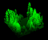
‘Visualizing’ forests from computer and other technological data is common practice in the field of forestry. Forest visualization is used for stand and landscape management and to predict future environmental conditions. Currently, most visualization software packages focus on one forest stand at a time (hundreds of acres), but now we can visualize an entire forest, from ridge top to ridge top. The Sierra Nevada Adaptive Management Project (SNAMP) Spatial Team principle investigators Qinghua Guo, associate professor in the UC Merced School of Engineering; Maggi Kelly, UC Cooperative Extension specialist in the...

- Author: Kim Ingram
UC scientists with the Sierra Nevada Adaptive Management Project (SNAMP) are investigating the uses of Lidar (light detection and ranging) in providing detailed information on how forest habitat is affected by fuels management treatments across a large landscape. Mapping forest structure can illustrate how a forest influences surface hydrology, provides for wildlife and how a forest might burn given certain weather and wind patterns. This research is proving useful in wildlife studies, water quantity and fire modeling and forest planning.
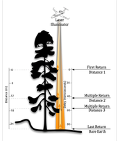
Airborne lidar works by emitting a light pulse from an emitter onboard a plane towards a ground target. A portion of the light is reflected back to...

