University of California
Dev Test!

Calag Archive

Calag Archive
California Agriculture, Vol. 69, No.1

Forestry: Managing for the future
Cover: 

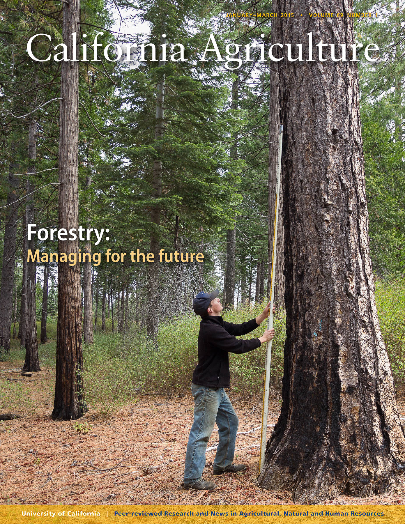
Prescribed burning helps to reduce fuels on the forest floor, clear dense understory vegetation and increase diversity in forests. Controlled fires and mechanical treatments can greatly reduce the risk of catastrophic wildfire. In the cover photo, Darrik Carlson, a research assistant at UC Berkeley’s Blodgett Forest Research Station in El Dorado County, measures the height of the charred bark on a 100-year-old mature tree after a prescribed burn. Photo by Will Suckow.

January-March 2015
Volume 69, Number 1

Peer-reviewed research and review articles

Mapping forests with Lidar provides flexible, accurate data with many uses
by Maggi Kelly, Stefania Di Tommaso
| Full text HTML  | PDF  
The powerful mapping capabilities of Lidar soon may be widely available to California forest managers as costs fall and the technology improves.
The use of remote sensing for forest inventory, fire management and wildlife habitat conservation planning has a decades-long and productive history in California. In the 1980s, mappers transitioned from aerial photography to digital remote sensing, in particular Landsat satellite imagery, which still plays a significant role in forest mapping, but today mappers increasingly rely on Lidar analysis. In California, where forests are complex and difficult to accurately map, numerous remote sensing scientists have pioneered development of methodologies for forest mapping with Lidar. Lidar has been used successfully here in a number of ways: to capture forest structure, to map individual trees in forests and critical wildlife habitat characteristics, to predict forest volume and biomass, to develop inputs for forest fire behavior modeling, and to map forest topography and infrastructure. Lidar can be costly to acquire and difficult to analyze, but as costs decline and new data processing methods are developed, it is likely that forest managers who need detailed information on forest structure across large spatial scales will incorporate Lidar data into their mapping toolkits.
Carbon calculator tracks the climate benefits of managed private forests
by William C. Stewart, Benktesh D. Sharma
| Full text HTML  | PDF  
Private forests that are harvested and regenerated yield approximately 30% more carbon sequestration benefits than if they are left to grow.
As part of California's strategy to reduce greenhouse gas emissions, private forest landowners are now required to address carbon sequestration as a management goal when submitting timber harvest plans. Using public data on forests and forest products, we developed a calculator that tracks the carbon sequestration benefits related to live trees, wood used for bioenergy and wood going into products. The calculator is adapted for different forest types, forest management techniques and time frames. Based on current best practices used in California, we estimate that harvested and regenerated forests will provide approximately 30% more total carbon sequestration benefits than forests left to grow for an equal time. More than half of the total benefits relate to harvested wood substituting for fossil fuels and fossil fuel–intensive materials such as cement and steel. With relatively efficient management practices, harvesting a ton of wood provides more sequestration benefits than leaving that ton growing in the forest.
Large-tree removal in a mixed-conifer forest halves productivity and increases white fir
by Robert A. York
| Full text HTML  | PDF  
A long-term study in the Sierra Nevada confirms the negative consequences of preferentially removing large trees.
Removing all large trees without planning to replace them with either planted or naturally regenerated younger trees (i.e., high-grading) is widely thought to have negative consequences on a forest's productivity and species composition, but no previous studies in California had evaluated this assumption. To make such an evaluation, I measured productivity and canopy species composition shifts following the repeated removal of large trees and compared the results with those from two other basic forest harvest methods: thinning from below and single tree selection. Timber productivity was substantially lower with large-tree removal (0.65 thousand board feet per acre per year) than with the other methods (averaging 1.33 thousand board feet per acre per year), which included the no-harvest control, where yield was zero. Large-tree removal also resulted in more species change, with white fir increasing in the canopy and ponderosa pine decreasing.
Post-fire vegetation dynamics of a sagebrush steppe community change significantly over time
by Sara K. Hanna, Kenneth O. Fulgham
| Full text HTML  | PDF  
Nearly 30 years after a burn at two sites in northeastern California, sagebrush had recovered fully and invasive grasses had diminished.
Sagebrush steppe ecosystems of the Intermountain West have experienced a decline over the past 150 years due to changing fire regimes, invasive species and conifer encroachment. Prescribed fire is a common and cost-effective tool used in sagebrush restoration and fuels management. We examined the post-fire succession of a sagebrush steppe community over a nearly 30-year period at two study sites in northeastern California. The long-term nature of this study was particularly significant, as invasive annual grasses dominated the plant community in the years immediately following fire, but native perennial grasses and shrubs successfully out-competed them in the long term. Shrubs were slow to recover but had returned to pre-fire levels by the end of the study period. There was also notable increase in western juniper throughout the study sites, particularly in areas that had not been burned. Our results indicate that mean fire return intervals of 50 years or less would help reduce western juniper encroachment and preserve sagebrush habitat, especially for potentially threatened species such as the sage grouse.
UC plays a crucial facilitating role in the Sierra Nevada Adaptive Management Project
by Adriana Sulak, Lynn Huntsinger, Susan D. Kocher
| Full text HTML  | PDF  
All sides of the Sierra forest management debate have learned from SNAMP. Can stakeholders help ensure research results are part of future management?
The 2004 Sierra Nevada Forest Plan Amendment adopted by the U.S. Forest Service called for using adaptive management — management through deliberate experimentation — to carry out treatments to improve forest health and reduce fire severity. The Sierra Nevada Adaptive Management Project (SNAMP), begun in 2005 and ending this year, has developed, implemented and evaluated participatory adaptive management processes in two national forests for applying fuels management treatments based on strategically placed patterns of tree thinning. SNAMP participants include federal and state agencies, the University of California and many members of the public. UC Cooperative Extension staff members have played an important role in facilitating the participation of public stakeholders. In 2010, a survey showed that stakeholders valued the learning opportunities of the project, especially appreciating the open discussions, public input and face-to-face contact with scientists. Despite the institutional limits to sharing decision making, an environment conducive to the social learning characteristic of collaborative adaptive management projects was created. The SNAMP process may lead to long-term relationships and knowledgeable stakeholders who can support the Forest Service's use of the project findings after UC's role ends.
Cooperative, cross-boundary management facilitates large-scale ecosystem restoration efforts
by Erin Kelly, Jonathan Kusel
| Full text HTML  | PDF  
A cooperative meadow restoration plan that successfully engaged a diverse group of stakeholders is a model for future projects.
In California and across the United States, landscape restoration projects often require cross-boundary cooperation, though successful examples are rare and not well understood. This case study describes the Burney Gardens timber harvesting plan, a cooperative, cross-boundary meadow restoration project undertaken by private corporate forest landowners in Northern California as part of a larger collaborative restoration effort. The project is notable because it (1) received institutional support — both financial and political — from federal, regional and local sources and (2) engaged a diverse group of stakeholders in pre-project planning with multiple agency partners. This approach enabled the project plan to pass through the rigorous California regulatory system in an unusually rapid fashion despite its complexity. The collaborative model of the Burney Gardens project is relevant to other restoration efforts, particularly as diverse ownerships across the West implement large-scale projects that cross property boundaries, including those of federal and private lands.
UC Cooperative Extension works with fire safe councils to reduce wildfires
by Glenn A. Nader, Michael De Lasaux
| Full text HTML  | PDF  
The collaborative partnership has improved fire safety in fire-prone Plumas, Butte and Yuba county communities and stopped major wildfires.
In Plumas, Butte and Yuba counties, UC Cooperative Extension advisors have collaborated with fire safe councils to mitigate the risk of wildfire in local communities. They have determined the educational needs within the communities, obtained grant funding and worked collaboratively with the councils to deliver education and applied research programs that have helped homeowners and landowners take action to reduce their vulnerability to the risk of wildfires. Home structures have been modified to improve their fire resistance, fuel reduction programs have been adopted by local communities and maintained, communities have been mapped for evacuation plans and fuel breaks have been constructed on private and public forestland. Several wildfires, including the Marysville fire in 2006 and the Yuba fire in 2009, were slowed or stopped because of measures taken, showing the value of investment in pre-fire planning and actions.
Webmaster Email: bjnoel@ucanr.edu

Thank you for visiting us at California Agriculture. We have created this printable page for you to easily view our website offline. You can visit this page again by pointing your Internet Browser to-

http://ucanr.edu/sites/dev_test/archive/index.cfm?issue=69_1

California Agriculture, Vol. 69, No.1

Forestry: Managing for the future
Cover: 

Prescribed burning helps to reduce fuels on the forest floor, clear dense understory vegetation and increase diversity in forests. Controlled fires and mechanical treatments can greatly reduce the risk of catastrophic wildfire. In the cover photo, Darrik Carlson, a research assistant at UC Berkeley’s Blodgett Forest Research Station in El Dorado County, measures the height of the charred bark on a 100-year-old mature tree after a prescribed burn. Photo by Will Suckow.

January-March 2015
Volume 69, Number 1

Peer-reviewed research and review articles

Mapping forests with Lidar provides flexible, accurate data with many uses
by Maggi Kelly, Stefania Di Tommaso
| Full text HTML  | PDF  
The powerful mapping capabilities of Lidar soon may be widely available to California forest managers as costs fall and the technology improves.
The use of remote sensing for forest inventory, fire management and wildlife habitat conservation planning has a decades-long and productive history in California. In the 1980s, mappers transitioned from aerial photography to digital remote sensing, in particular Landsat satellite imagery, which still plays a significant role in forest mapping, but today mappers increasingly rely on Lidar analysis. In California, where forests are complex and difficult to accurately map, numerous remote sensing scientists have pioneered development of methodologies for forest mapping with Lidar. Lidar has been used successfully here in a number of ways: to capture forest structure, to map individual trees in forests and critical wildlife habitat characteristics, to predict forest volume and biomass, to develop inputs for forest fire behavior modeling, and to map forest topography and infrastructure. Lidar can be costly to acquire and difficult to analyze, but as costs decline and new data processing methods are developed, it is likely that forest managers who need detailed information on forest structure across large spatial scales will incorporate Lidar data into their mapping toolkits.
Carbon calculator tracks the climate benefits of managed private forests
by William C. Stewart, Benktesh D. Sharma
| Full text HTML  | PDF  
Private forests that are harvested and regenerated yield approximately 30% more carbon sequestration benefits than if they are left to grow.
As part of California's strategy to reduce greenhouse gas emissions, private forest landowners are now required to address carbon sequestration as a management goal when submitting timber harvest plans. Using public data on forests and forest products, we developed a calculator that tracks the carbon sequestration benefits related to live trees, wood used for bioenergy and wood going into products. The calculator is adapted for different forest types, forest management techniques and time frames. Based on current best practices used in California, we estimate that harvested and regenerated forests will provide approximately 30% more total carbon sequestration benefits than forests left to grow for an equal time. More than half of the total benefits relate to harvested wood substituting for fossil fuels and fossil fuel–intensive materials such as cement and steel. With relatively efficient management practices, harvesting a ton of wood provides more sequestration benefits than leaving that ton growing in the forest.
Large-tree removal in a mixed-conifer forest halves productivity and increases white fir
by Robert A. York
| Full text HTML  | PDF  
A long-term study in the Sierra Nevada confirms the negative consequences of preferentially removing large trees.
Removing all large trees without planning to replace them with either planted or naturally regenerated younger trees (i.e., high-grading) is widely thought to have negative consequences on a forest's productivity and species composition, but no previous studies in California had evaluated this assumption. To make such an evaluation, I measured productivity and canopy species composition shifts following the repeated removal of large trees and compared the results with those from two other basic forest harvest methods: thinning from below and single tree selection. Timber productivity was substantially lower with large-tree removal (0.65 thousand board feet per acre per year) than with the other methods (averaging 1.33 thousand board feet per acre per year), which included the no-harvest control, where yield was zero. Large-tree removal also resulted in more species change, with white fir increasing in the canopy and ponderosa pine decreasing.
Post-fire vegetation dynamics of a sagebrush steppe community change significantly over time
by Sara K. Hanna, Kenneth O. Fulgham
| Full text HTML  | PDF  
Nearly 30 years after a burn at two sites in northeastern California, sagebrush had recovered fully and invasive grasses had diminished.
Sagebrush steppe ecosystems of the Intermountain West have experienced a decline over the past 150 years due to changing fire regimes, invasive species and conifer encroachment. Prescribed fire is a common and cost-effective tool used in sagebrush restoration and fuels management. We examined the post-fire succession of a sagebrush steppe community over a nearly 30-year period at two study sites in northeastern California. The long-term nature of this study was particularly significant, as invasive annual grasses dominated the plant community in the years immediately following fire, but native perennial grasses and shrubs successfully out-competed them in the long term. Shrubs were slow to recover but had returned to pre-fire levels by the end of the study period. There was also notable increase in western juniper throughout the study sites, particularly in areas that had not been burned. Our results indicate that mean fire return intervals of 50 years or less would help reduce western juniper encroachment and preserve sagebrush habitat, especially for potentially threatened species such as the sage grouse.
UC plays a crucial facilitating role in the Sierra Nevada Adaptive Management Project
by Adriana Sulak, Lynn Huntsinger, Susan D. Kocher
| Full text HTML  | PDF  
All sides of the Sierra forest management debate have learned from SNAMP. Can stakeholders help ensure research results are part of future management?
The 2004 Sierra Nevada Forest Plan Amendment adopted by the U.S. Forest Service called for using adaptive management — management through deliberate experimentation — to carry out treatments to improve forest health and reduce fire severity. The Sierra Nevada Adaptive Management Project (SNAMP), begun in 2005 and ending this year, has developed, implemented and evaluated participatory adaptive management processes in two national forests for applying fuels management treatments based on strategically placed patterns of tree thinning. SNAMP participants include federal and state agencies, the University of California and many members of the public. UC Cooperative Extension staff members have played an important role in facilitating the participation of public stakeholders. In 2010, a survey showed that stakeholders valued the learning opportunities of the project, especially appreciating the open discussions, public input and face-to-face contact with scientists. Despite the institutional limits to sharing decision making, an environment conducive to the social learning characteristic of collaborative adaptive management projects was created. The SNAMP process may lead to long-term relationships and knowledgeable stakeholders who can support the Forest Service's use of the project findings after UC's role ends.
Cooperative, cross-boundary management facilitates large-scale ecosystem restoration efforts
by Erin Kelly, Jonathan Kusel
| Full text HTML  | PDF  
A cooperative meadow restoration plan that successfully engaged a diverse group of stakeholders is a model for future projects.
In California and across the United States, landscape restoration projects often require cross-boundary cooperation, though successful examples are rare and not well understood. This case study describes the Burney Gardens timber harvesting plan, a cooperative, cross-boundary meadow restoration project undertaken by private corporate forest landowners in Northern California as part of a larger collaborative restoration effort. The project is notable because it (1) received institutional support — both financial and political — from federal, regional and local sources and (2) engaged a diverse group of stakeholders in pre-project planning with multiple agency partners. This approach enabled the project plan to pass through the rigorous California regulatory system in an unusually rapid fashion despite its complexity. The collaborative model of the Burney Gardens project is relevant to other restoration efforts, particularly as diverse ownerships across the West implement large-scale projects that cross property boundaries, including those of federal and private lands.
UC Cooperative Extension works with fire safe councils to reduce wildfires
by Glenn A. Nader, Michael De Lasaux
| Full text HTML  | PDF  
The collaborative partnership has improved fire safety in fire-prone Plumas, Butte and Yuba county communities and stopped major wildfires.
In Plumas, Butte and Yuba counties, UC Cooperative Extension advisors have collaborated with fire safe councils to mitigate the risk of wildfire in local communities. They have determined the educational needs within the communities, obtained grant funding and worked collaboratively with the councils to deliver education and applied research programs that have helped homeowners and landowners take action to reduce their vulnerability to the risk of wildfires. Home structures have been modified to improve their fire resistance, fuel reduction programs have been adopted by local communities and maintained, communities have been mapped for evacuation plans and fuel breaks have been constructed on private and public forestland. Several wildfires, including the Marysville fire in 2006 and the Yuba fire in 2009, were slowed or stopped because of measures taken, showing the value of investment in pre-fire planning and actions.

University of California, 1301 S. 46th St., Bldg. 478 Richmond, CA
Email: calag@ucanr.edu | Phone: (510) 665-2163 | Fax: (510) 665-3427
Please visit us again at http://californiaagriculture.ucanr.edu/