Shades of brown and grey cast over bricks, cement, remnants of metal roofs and steel beams from manufactured and modular homes, collapsed stucco walls, BBQs, shells of washers and driers, along with an occasional tea pot—that is what you can see in and amongst living, but singed Ponderosa pine and California black oak trees where the Camp Fire burned. How did California's most deadly fire happen and what might be done differently to ensure a better outcome? These are difficult questions that California will wrestle with for a long time to come.
Last week I was able to tour some of the burned area in Paradise and Magalia to evaluate why some homes survived and others did not. This gave me a chance to look at homes that survived largely on their material selection, design details, the owner's maintenance efforts, and not necessarily with the aid of a fire crew or resident that stayed. Many of the buildings that were burned were lost on the first day or two of the fire while emergency response was focused on evacuating the communities. It will take months to make sense of this mess and tragedy, but during my tour some conditions rang true to me.
Wildfire is not uniform. Not all fires are the same and not all houses experience the same type of fire. When you are looking at home losses and survivors, keep in mind that each home may not have had the same fire exposure. Some homes experienced significant ember exposure, while others ignited because their neighbor's home succumbed to fire and the heat of their neighbor's house caught their house on fire, while others were protected from the wind and its deadly embers. Paradise and Magalia have blocks and blocks of nothing but foundations, but amongst these bleak conditions are a few intact or partially damaged homes that have a story to tell.
We saw homes that survived that had upgraded attic and foundation vents that meet the California building code for construction in wildfire prone areas. Some of these houses also included some extra efforts where vegetation and combustible mulch was virtually eliminated in the area immediately adjacent to the home. Our inspection team included UC's Dr. Steve Quarles, a national expert in fire-safe construction, who interpreted this to mean that meeting the 2008 Chapter 7 A standards, coupled with the enhanced defensible space, likely made the difference to ward off the assault of the ember-driven Camp Fire. We found evidence that burned homes in Paradise had ¼” mesh foundation and under-eave vent screens. Research has shown that these larger size screens let embers penetrate the attic and ignite the house from within. The 2008 California building code standards specify screen mesh size between 1/8” and 1/16”-inch, or vents that demonstrate their ability to resist embers and flames.
Our tour also confirmed that landscaping plants and wood mulchplaced right next to the house creates vulnerability. While looking at the rubble of a home, it can be difficult to tell what happened; however, we saw several surviving houses with broken glass or otherwise damaged dual-pane windows that experienced heat exposures sufficient to crack glass in the windows, but the home still survived during these first two days when fire crews were rightly focused on community evacuation and not structure protection. For the houses that did not survive, we can interpret that in addition to the vulnerabilities in vents or a roof, heat can easily break glass in windows, especially if those windows are single pane, and can likely created a pathway for fire to enter the houses.
Home placement makes a difference. A home at the top of a canyon or gulch can easily be overwhelmed by wildfire by taking on additional heat as the fire approaches and being blasted with embers. This is not a new concept, but the homes in the broader Paradise region were especially vulnerable when they were located above these gulches and canyons. Enhanced vegetation management is highly recommended that includes a 5-foot non-combustible zone immediately adjacent to the home.
Our team, which also included Dr. Eric Knapp from the USDA Forest Service Pacific Southwest Research Station, has been able to do a quick analysis of home losses by year of construction in Paradise. This cursory analysis shows that many homes built after the 2008 wildfire standards were adopted were lost during this fire, however, without knowing the specific details of each home (e.g., maintenance practices, proximity to other building, etc.), these statistics can be misleading. We will continue to work through the available data to try to look for patterns, however, in the meantime, it seems clear to me that the new construction standards can reduce the probability of ember intrusion and may have helped for some homes in Paradise. This week a new study reported that complying with these standards was not considerably more expensive. Additionally, the codes that help guide construction in California's wildfire-prone areas are dynamic and will be informed by the 2017 and 2018 wildfire seasons.
For me thinking about Paradise in the abstraction was easy. Visiting it was different. The name says it all. After my visit I could understand why someone would choose Paradise or Magalia; the views are awesome, the air is clear, the forest and woodlands are amazing. I can only imagine that the community was (almost) perfect. Rebuilding a more resilient community will take considerable thought, effort, and some radical new ideas.
The world certainly seems more flammable these days. Thousands of homes were lost last year in Sonoma County alone, and wildfires have raged across California all summer. And not just in California: Records from the federal National Interagency Fire Center show that U.S. acreage burned in wildfires leaped from 1.8 million in 1995 to 10 million in 2017.
But even as the burned acreage has jumped exponentially, the number of fires—or “ignitions” in wildfire-speak—dropped significantly, from 82,234 in 1995 to 71,499 in 2017. Why the discrepancy? Put simply, fires are getting harder to control, so they're getting bigger. To blame are the build-up of forest fuels from decades of aggressive fire suppression as well as drier, hotter, and windier conditions caused in large part by climate change.
That's only part of the problem, though. The fires are getting costlier, both in terms of human life and property loss. And a major—perhaps the major—driver to this trend is the “expanding bull's eye” of high-risk development, specifically the rapid growth of Wildland-Urban Interface (WUI).
Conceptual model of the “expanding bull's-eye effect” with increasing development spreading from an urban core over time. // Ashley et al. 2014
“Interface” is that transitional zone between suburbs or cities and forested areas. From a firefighter's perspective, WUI combines the worst of both realms: Interface areas are not only cheek-to-jowl with fuel-rich forests, they're also often characterized by dense housing tracts landscaped with lush, highly flammable vegetation. Today's wildfires, in short, are not your grandpa's wildfires; they're usually hybrid, human-started fires, involving both structures and forests, which greatly complicates the task for wildfire fighters and escalates the cost in life and property.
A recent study shows that WUI, primarily from suburban and recreational development, is the fastest-growing land-use category in the lower 48 states. And home losses from wildfire correspond directly to the expansion of interface.
Anu Kramer, a postdoctoral research associate at the University of Wisconsin who took her PhD in environmental science, policy and management at Cal, co-authored the paper in the Proceedings of the National Academy of Sciences that examined WUI changes from 1990 to 2010.
“We found that there was a 33 percent increase in WUI for the period and a 41 percent increase in new homes built in WUI areas—from 30.8 million to 43.4 million,” Kramer said—meaning there are more and more zones where development abuts wildland. “Basically, this translates as greatly increased fire risk.”
Kramer and her colleagues confirmed that post-fire construction tends to concentrate in areas of equal or higher fire risk than those that had last burned.
Those statistics suggest that neither policy makers nor home owners have grasped the profound risks implied by building in pleasant, leafy—and highly combustible—environs, particularly in the West.
“The main takeaway from our most recent research is that these interface areas need to be targeted for outreach—education for home owners on creating defensible spaces, and regulations, and funding that would result in such things as fuel breaks, more sensible zoning, and mandates on fire resistant construction materials.”
Instead, there seems to be a kind of collective determination to repeat the mistakes of the past.
“I'm involved in some research on rebuilding trends after wildfires, looking at where new homes are going in,” said Kramer. “On average, 94 percent of buildings [in a burn zone] have been rebuilt after 25 years.”
Kramer and her colleagues created a computer model, which confirmed that post-fire construction tends to concentrate in areas of equal or higher fire risk than those that had last burned.
“Miranda Mockrin [a researcher with the U.S. Forest Service] has done a lot of work in Colorado on the social science aspects of wildfire,” Kramer said. “She looked at zoning changes after fires and found that yes, sometimes zoning gets stricter and people may be encouraged to build with materials that are more fire-safe, but in the majority of cases there were no changes, and in some instances restrictions were actually reduced. The potential for learning and adaptation after fires just isn't being fulfilled.”
Local governments are incentivized to rebuild as quickly as possible to recoup lost tax revenues and bring civic and economic life back to comfortable baselines.
That dynamic seems in play in the North Bay, observed Kramer, where homes currently are being rebuilt in the exclusive Fountaingrove area. This enclave of expensive houses was located along a ridge on the margins of Santa Rosa. Just under a year ago on the evening of October 8 th , the Tubbs Fire roared through the neighborhoods, consuming most of the homes and killing several people. The steep slopes and canyons of the ridge acted as chimneys, concentrating the full fury of the wind-driven flames onto the ridge top development.
It was a horrific event, but it was hardly an outlier. In fact, it had been predicted. In 1964, the Hanley Fire tracked virtually the same route as the Tubbs Fire, including the area now occupied by Fountaingrove. But in 1964, Fountaingrove didn't exist, and the Hanley Fire destroyed relatively few structures. When construction on Fountaingrove started in the 1990s, many residents protested to Santa Rosa regulators, citing the Hanley blaze.
So why rebuild in high-risk areas? As Kramer explains, local governments are incentivized to rebuild as quickly as possible to recoup lost tax revenues and bring civic and economic life back to comfortable baselines. Unfortunately, environmental and geophysical changes—more frequent high wind events, longer and more frequent droughts, higher summertime temperatures and milder winters—mean that an increasing number of communities, even those outside of wildland interfaces, are considered high-risk for catastrophic wildfire.
The past few fire-ravaged years have made it clear that we have reached a tipping point. Epic wildfires seem certain to gain in frequency and destructive power in coming decades.
The Tubbs Fire, for example, didn't just burn Fountaingrove, a development with a significant WUI. It also flattened 1,200 homes in Coffey Park, an older middle-class development in a thoroughly suburban area located west of Highway 101 and far from anything that could be construed as a “wildland.” Extremely high winds drove masses of embers across 101, where they ignited structures and landscaping in Coffey Park and surrounding business complexes. Such winds were once considered anomalous by fire scientists. Not anymore. If ferocious wildfire-associated winds aren't the new normal, they're on their way. Winds reaching 143 mph destroyed scores of homes in the recent Carr Fire in Redding, during which a literal fire tornado killed two firefighters.
“[The Tubbs and Carr Fires] demonstrate how these strong winds can influence where a fire goes and what it does,” said Kramer. “They also show we need better models for predicting impacts and assessing risks. The models currently used by Cal Fire [California's state wildfire fighting agency] have a pretty basic wind component that doesn't account for the kind of high wind events we've begun seeing. So Max Mortiz [the head of the Mortiz Fire Regimes and Ecosystems Management Lab at Cal] is working with Cal Fire to bring their models up to date.”
The past few fire-ravaged years have made it clear that we have reached a tipping point. Epic wildfires are no longer rare, and they seem certain to gain in frequency and destructive power in coming decades. Moreover, the number of communities at dire risk is much higher than has been assumed. As Kramer's work reveals, wildfire losses seem proportional to the growth of WUI. We can't eliminate wildfire, but we can certainly reduce the impacts.
Paradoxically, that involves introducing more fire—controlled fire—into our wildlands to consume heavy fuel concentrations. It also entails moderating the dizzying expansion of WUI. Left unregulated, the trends in housing growth will simply perpetuate the destruction.
Reposted from UC Davis News The Northern California wildfires of 2017 may have created new kinds of pollutants by incinerating housing materials and household items. UC Davis researchers will study samples of ash and air from sites such as this house in Larkfield-Wikiup and plan to survey residents on their experiences. (Photo by Gabrielle Black)
When fires ripped through suburban subdivisions in Santa Rosa last October, they may have done more than reduce homes to ashes. By incinerating all kinds of materials — insulation, electronics, furniture, cleaning products, pesticides — at very high temperatures, they could have created unknown or previously unrecognized health hazards in the smoke and ash. Researchers from the University of California, Davis, are trying to figure out just what is in that ash and air.
“What we're interested in looking for are transformation products of household products that have burned in the fires,” said Gabby Black, a fourth-year graduate student in agricultural and environmental chemistry at UC Davis.
According to Tom Young, professor in the Department of Civil and Environmental Engineering and Black's faculty advisor, the health hazards these compounds pose are not yet known.
“Conventional assessments rely on things that we already know are pollutants, such as industrial chemicals,” Young said. “But we don't know what new chemicals might have been created from combustion.”
The Northern California Fire and Health Impacts project, also known as “Wildfires and Health: Assessing the Toll in NorthWest California” (WHAT NOW-California) is led by Irva Hertz-Picciotto, professor of public health sciences and director of the UC Davis Environmental Health Sciences Center. In addition to sampling ash and air, researchers from the center plan to survey residents of Napa, Sonoma and other Northern California counties affected by the fires or the smoke. The survey asks about how the fires have affected them and other household members, including their experiences as well as their health before, during and after the fires.
Black, who was born and raised in Sonoma, has collected ash samples from a series of sites burned by the Tubbs Fire in October, from wildland in Robert Louis Stevenson State Park into the city of Santa Rosa.
In addition, researcher Keith Bein and colleagues from the UC Davis Air Quality Research Center plan to regularly collect air samples from these sites as the area recovers from the fires. While the fires were still burning, Bein's team collected samples of smoky air in the Bay Area and Davis. But for years to come, they expect, dust in the burned area will contain particles of fire ash. The researchers will look specifically at airborne particles less than 2.5 microns in size that can penetrate deep into the lungs.
Air and ash samples will be analyzed by the latest techniques that can generate high-resolution profiles of hundreds or thousands of molecules in a sample. The researchers will compare the samples to existing databases and also look for new compounds.
“This was a very unique type of fire, an urban wildfire,” Bein said. “We know what wildfire smoke is composed of, but we have no idea what will be in this — we expect it to be very different.”
The air quality team has set up a mobile air sampling unit powered by an electric vehicle. The system can carry out 24 hours of continuous sampling in a remote area with no accessible power. They plan to begin monthly sampling in the Sonoma and Napa areas this spring. In future, Bein hopes that the mobile unit can be deployed quickly into an affected area.
The project has received initial funding from the UC Davis Environmental Health Science Center, sponsored by the National Institute for Environmental Health Sciences. Black is supported by an NSF graduate student fellowship.
I was nine years old when my dad's family home burned in the Oakland Hills Fire. As a country kid from one of the most fire-prone counties in northern California, I was no stranger to wildfire. Still, I remember the shock of driving through his childhood neighborhood in the weeks after the fire, seeing nothing but the skeletal remains of vehicles and homes — so different than the forest fires that I was used to back in Trinity County.
Those images came back to me a few weeks ago when I gave a presentation at a workshop in Redwood Valley, California. That community, which is in Mendocino County, suffered a devastating wildfire in October, during the same week that fires were burning throughout Sonoma and Napa counties. During the Redwood Valley Fire, nine people were killed and more than 500 structures were destroyed. Now more fires are burning in southern California, and in some ways, it seems that the human connection — the loss of lives, the loss of homes — is the defining feature of this year's fire season in California.
Redwood Valley Fire damage. “In some ways, it seems that the human connection — the loss of lives, the loss of homes — is the defining feature of this year's fire season in California.” Credit: Lenya Quinn-Davidson, Fire Adapted Communities Learning Network
One of my close colleagues at the University of California Cooperative Extension, Yana Valachovic, has no doubt felt the human implications of the 2017 fire season. Her phone has been ringing off the hook for months because of her expertise and experience in home ignitions and home survival: concepts that people are desperate to understand and implement in light of the ongoing losses throughout the state.
In some ways, the research on home survival during wildfire is intuitive; most people understand defensible space concepts and the basics of fuels management. But there are so many ways that most of us could do better — ways that are well illustrated by my own friends, colleagues and family.
Yana talks about how even she — someone who studies this topic — stores paper bags full of her kids' old schoolwork in her attic, right next to the vents. And if you read the literature on this topic, you know that vents represent a major vulnerability during wildfire. Most homes burn from the inside out, meaning that embers make their way into the home through vents and other crevices, and they then ignite fuels inside the house. Once embers infiltrate, it's hard to slow them down — hence the photos we often see of blackened homes surrounded by green trees and intact neighborhoods.
Click on the image above to access Dr. Steve Quarles' new report, Vulnerability of Vents to Wind-Blown Embers
Current research supports the use of finer mesh vent screens (typically a second screen behind the outer screen), and/or temporary vent covers during wildfire events. There is an impressive amount of information available on home venting and fire, including the desired fineness of screen meshes, the use of ridge vents and the appropriateness of unvented attics (PDF, 213 MB). Much of this work comes from the Insurance Institute for Business and Home Safety (IBHS). Steve Quarles leads IBHS's fire-related research program and has published a number of papers on this topic, including a new report, Vulnerability of Vents to Wind-Blown Embers.
Homes can also burn from the outside in, thanks again, in large part, to embers. A few years ago, when a wildfire came within a half mile of my mom's house, I found her gutters packed with dry leaves. This is a classic problem, and one that I was surprised to see at my own mom's house. How did we let the gutters fill up like that, knowing what we know? Gutters full of debris, if ignited, will provide direct flame and ignition to the edge of the roof; if the roof is not adequately protected by metal flashing, or if the gutter is below the roof edge exposing the vulnerable roof sheathing, it can be difficult to keep fire from spreading from the gutter into the house. In 2010, when Quarles was with University of California, he co-authored a great publication that discusses rain gutters, vents, roofing, decks and other home vulnerabilities (PDF, 4.87 MB).
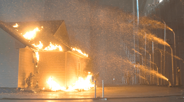
There is also a fair amount of research on features adjacent or attached to the home — features like decks, fences and landscaping (PDF, 416 KB). Still, on a recent trip to a research station in southwest Georgia (a place known for its fire science research and active fire management), I was surprised to see that the landscaping around every building had a thick mulching of longleaf pine needles — literally one of the most flammable types of leaf litter in the world. It looked great but wouldn't be particularly helpful if a fire came through. And IBHS wildfire demonstrations, like this one from 2011, have shown that mulches and other near-home landscaping can become serious points of weakness during wildfire. (I highly recommend checking out their video demonstrations if you haven't before; they have a lab where they actually burn down full-sized homes.)
Now I know that this information is likely old news to many of you; I hesitated to write about this topic because our readership is probably fairly fluent in the research on home ignitions and survival. But the images of Yana's attic full of well-cured paper, my mom's gutters full of leaves, and the pine needle mulch at the research station in Georgia reminded me that we all have more we can do — even if we're well-versed in how homes burn. Home hardening is, of course, only one facet of fire adaptation, but this year's fires reinforced the importance of all efforts at all scales, from the vent and the gutters to the community wildfire protection plan and the prescribed burn.


")