Posts Tagged: mapping
Farm Preparation for Wildfire and Other Emergencies

According to many state fire officials, we no longer have simply a ‘Fire Season' but a ‘Fire Year'. In winter drought conditions, some parts of our region do not receive enough rain to mitigate fire danger. It is more important than ever to constantly assess your farm for fire safety and be prepared for any emergency.
The following information will assist you in thinking through four important areas of disaster preparedness for your farm: Paperwork & Plans, Farm Map & Layout, Tools & Machinery, and Operations & Training.
Paperwork & Plans:
- Conduct a fire risk assessment and record your findings. Assess brush clearance, road access, evacuation routes, defensible space, topography (fire climbs hills quickly), and water sources. If needed, make a plan to address any critical issues.
- Evaluate current insurance coverage to ensure adequate coverage for farm assets. Consider livestock, crops, buildings, and equipment.
- Keep up-to-date production, marketing, and financial records. Check the Foothill Farming website resources on risk management and business planning tools for templates. Scan or store them on a USB flash drive or external hard drive.
- Make a farm communication plan. What happens if you are not home during a disaster situation? Do you have phone numbers and good relationships with neighbors? Are the phone numbers written down for your family members and employees as well?
- Create a farm emergency plan, use the following free online templates or use them as a guide to create one more suitable for your own farm.
- http://ucanr.edu/sites/placernevadasmallfarms/files/289237.pdf
- https://www.formsbank.com/template/325465/emergency-plan-for-farm-template.html?page=5
- http://www.maeap.org/uploads/files/EMERGENCY_PLANNING_fillable_Form_E2575-ET_AA.pdf
- http://www.ncagr.gov/disaster/Farm-Emergency-Plan-Template.pdf
Developing a farm emergency plan before a disaster can help you respond more rapidly and objectively.
Farm Map & Layout:
- A farm map should be part of your emergency plan. Create a map including symbols and a key for the following:
- Homes, barns, and outbuildings.
- Utility shutoffs.
- Power and utility lines.
- Fuel and chemical storage.
- Roads and bridges (including weight limitations).
- Water sources and delivery systems.
- Gates (including combinations).
- Fuel breaks.
- Any other possible farm hazards.
You may include brief general guidance for emergency responders on the map as well.

- A well-maintained and accessible water source is critical. If possible, consider a water source for fire trucks. An accessible source includes:
- Defensible space.
- Gravel road access within 12 feet of water source.
- Minimum 45-foot radius turnaround close by.
- Post permanent signs indicating water source location.
- For more detailed information about what is needed at a water source, check out this information from Oregon State Extension https://catalog.extension.oregonstate.edu/sites/catalog/files/project/supplemental/pnw618/pnw618-chapter6.pdf
- Farm design should incorporate these principles, especially around structures. Create at least 100 feet of defensible space by:
- Removing flammable objects from around barns or dwellings (e.g. flammable vegetation, feed bags, cardboard boxes, plant debris, fuel, etc.).
- Breaking up fuel continuity by separating plants from each other in gardens and landscape design.
- Taking care in selecting, locating, and maintaining trees.
- Post a clearly visible sign with property name and number at the entrance.
Tools & Machinery:
- Carry fire extinguishers and fire tools, especially in off-road vehicles. (e.g. trucks and tractors), CalFire requires a 5-gallon water supply and a fire tool be carried in wildland settings – consider adding this equipment to your tool box!
- Conduct frequent inspections of farm machinery for debris removal. Pay attention to hazards associated with exhaust systems and catalytic converters.
- All farms should have proper personal firefighting equipment such as shovels, hoes, and fire extinguishers that all farm employees can carry.
- Use rodent deterrents as they can chew through electrical insulation.
- Limit or postpone machinery use on high fire danger days. If use is unavoidable, plan for competing tasks before 10:00 AM.
- Stay 30 minutes after machinery use is shut off to monitor fire risk.
- More tips on preventing farm equipment fires, http://www.redrivermutual.com/wp/wp-content/uploads/Preventing-Farm-Equipment-Fires4.pdf
Operations & Training:
- Conduct an annual fire plan and equipment “refresher” for all farm personnel. Consider labeling safety equipment and fire tools on your map, with signs for your employees and family. Train folks on how to use this equipment.
- Have a routine for “red flag days” such as delaying mowing or machinery use.
- Although California law requires all electric fences to have low-impedance chargers, check frequently to ensure wires are free of materials that may cause the fence to arc. Always operate according to manufacturer directions.
- Restrict or clearly designate smoking areas.
- Include fire danger mitigation and forest management in annual planning.
Fire prevention should be a year-round activity in our fire-prone region. Be sure to consider the needs of both family and farm personnel in any emergency situation. Proper planning now will help mitigate the inevitable stress involved in farm emergencies. We would love to hear your thoughts, plans, and ideas related to disaster preparedness. Please feel free to comment below.
Read About Your Soil
Here is a really good introduction to the use of the on-line Soil Survey from USDA. Maybe it is easier to follow than blogs I have posted in the past.
WASHINGTON — “Soil don't get no respect,” Rodney Dangerfield might have said (but didn't). Perhaps you know your state bird or flower, but do you know your state soil?
Well, in recent years soil has begun to get more respect. Since the celebration of the Soil Survey Centennial back in 1999, each state has been given its own official state soil. It was in 1899 that the U. S. Department of Agriculture started its survey of all the soils in the country.
SOILS COME IN MANY ‘Flavours'
You might wonder what a “soil survey” really is. Isn't it all just dirt — some perhaps stickier, or redder or deeper — that lies beneath forest, meadow, farm, home and garden?
There you go again. Not enough respect.
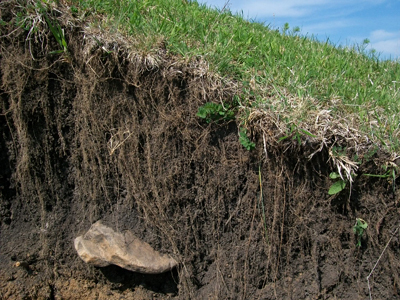
In fact, soils are distinctive, as different from each other as robins are from blue jays. These differences are hard to appreciate, of course, because soil is mostly underground, hidden from view. But if you were to dig some holes a few feet deep and then look carefully at their inside surfaces, you would find that soils are made up of layers of varying thickness, called horizons. One soil might differ from the next not only in the thickness of its horizons, but also in their appearance and feel.
Horizons might be as white as chalk, as red as rust, or as dark brown as chocolate. A horizon might be cement-hard, gritty with sand, or stuff for sculpture. And if you were to tease the dirt along one edge of the hole so it falls away naturally — wow! — each horizon would reveal its particles clumped together in arrangements like plates, blocks or prisms. Such information, and more, has allowed soils to be classified, much as birds, flowers and other living things are.
CLASSIFYING SOILS
Modern soil classification goes back only a few decades, when all the world's soils were grouped taxonomically into a dozen “orders.” Differences among orders reflect the formative influence of a particular combination of climate, plants and animals, topography, time and original rock material.
Just as all vertebrate animals are huddled together by biologists into smaller groupings (mammals, say) and those groupings into still smaller ones, so each soil order is divided and subdivided to include more distinctly different soils. At the end of the dividing and subdividing, you end up with a “soil series” identified with a proper name — like the Haven series in my vegetable garden, for example.
YOUR STATE'S AND BACKYARD'S SOIL
A particular soil becomes an official state soil by being widespread within the state; being distinctive chemically or physically; having some degree of name recognition; and, of course, getting a legislative stamp of approval. Examples include soils like West Virginia's Monongahela soil, Texas' Houston Black soil, California's San Joaquin soil and New York's Honeoye soil.
The job, now, of these “ambassadors” of the benevolent underworld is to rekindle awareness of soil's value as a natural resource that can only be renewed very slowly. Soil provides food, shelter, clothing and more, yet it is being lost at alarming rates to everything from blacktop to erosion.
Out in the garden this spring, dig a hole deep and wide enough that you can see and appreciate at least some of the various and distinctive horizons.
Then, if you want the name and a detailed description of that soil — or any soil — look at the maps and descriptions in the Soil Survey Reports issued by the U. S. Department of Agriculture, Natural Resource Conservation Service (NRCS). Search online for “soil survey nrcs” and you'll find links to soil maps for counties throughout the U.S. Or go to the link to “web soil survey.” At this site, you can type in a street address around which you “draw” your area of interest (AOI). The site will delineate the names and descriptions of soils within that AOI.
And of course this is available as an app at:
https://casoilresource.lawr.ucdavis.edu/soilweb-apps/
Online:
www.leereich.com/blog
leereich.com
http://www.leereich.com/2016/06/edens-gardens.html
soil weathered from rock
California Backyard Poultry Census
California Backyard Poultry Census
By: Myrna Cadena
Survey based and anecdotal observations demonstrate that backyard poultry ownership is increasing nationally and in California. At the same time, California's ability to provide resources to backyard poultry owners is limited. In addition, there are no effective ways to communicate with backyard poultry owners in a coordinated fashion. To address these issues, the UC Davis School of Veterinary Medicine and Cooperative Extension have made a short geo-survey (~2minutes) designed for the backyard poultry community. Results will help further clarify the location and number of backyard poultry farms in California. Furthermore, email addresses and other address information will help facilitate communication between poultry experts and backyard poultry enthusiasts. An example on the value of bridging the communication gap is being able to notify backyard poultry owners of an Avian Influenza outbreak. This will be extremely helpful in preventing another large outbreak.
With the help of ANR's GIS experts, the Cooperative Extension website now has an interactive map linked to a survey that acts as a census embedded at http://ucanr.edu/sites/poultry/California_Poultry_Census/. Shane Feirer's, Sean Hogan's, and Robert Johnson's expertise and receptiveness towards our goal have been of incalculable value to this project. It is always a pleasure working with such as hard-working team that always takes the time to answer our questions and concerns right away.

Volunteer weather observation helps scientists track storms
Sponsored in part by the National Oceanic and Atmospheric Administration (NOAA) and the National Science Foundation (NSF), the Community Collaborative Rain, Hail and Snow Network (CoCoRaHS) is a grassroots volunteer network of backyard weather observers.
With a presence in every state in the country, volunteers from all backgrounds work together to measure and map precipitation (rain, hail and snow) in their local communities. The data is used to help scientists across the country measure and track this very important and highly variable part of the climate system. By having thousands of volunteers nationwide providing precipitation data, scientists can track each storm system as it passes across the country and see how precipitation systems vary geographically, seasonally and inter-annually.
Many additional volunteers are needed to provide data for this long-term effort. CoCoRaHS provides training, education and an interactive website to which data is uploaded. It takes about five minutes a day to observe and upload data.
Volunteers can participate as much or as little as they wish. Individuals, groups and schools are welcome to participate. Currently volunteers range from kindergarteners to people in their 90s.
In addition to data collection, CoCoRaHS has many other opportunities for volunteers to become involved in this exciting project – locally, statewide and nationally.
To learn more or to sign up, please visit the CoCoRaHS website.
For additional questions, contact Nolan Doesken at the State Climatologist Colorado Climate Center, Department of Atmospheric Science, Colorado State University Fort Collins, CO 80523. He can be reached by email at nolan@atmos.colostate.edu or by phone 970.491.3690.

