- (Focus Area) Agriculture
- Author: Lynn Wunderlich

Biological control is defined as any activity of one species that reduces the adverse effects of another species. Living organisms are the agents of biological control, and although we may think of ladybugs and lacewings when we hear the term, bacteria and fungi can be biological control agents too! Microbes can act as antagonists to other microbes, they can out-compete them for nutrients or space, or they can secrete products that inhibit their growth. In fact, many biologically based pesticides harness the products of microbes, (think Bt or Spinosad).
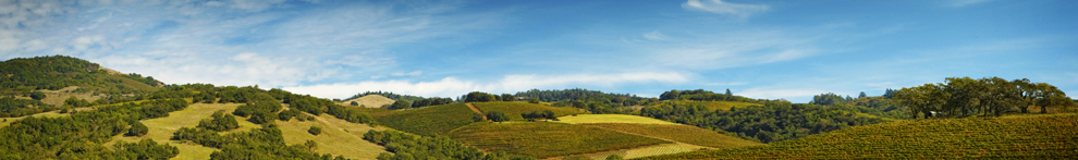
The target of this biocontrol search is a formidable one. Grapevine trunk disease is present in nearly every mature vineyard, shortening its life and productivity. Some have even referred to the trunk disease epidemic as the "next phylloxera," because the disease is so devastating to vineyards.
The disease is caused by several fungi, all entering the vine via spores carried by rain on pruning wounds. Esca (called measles for the spotting on the fruit), Eutypa dieback, Botryosphaeria dieback, and Phomopsis, are all considered grapevine "trunk diseases"-infection can run from the pruning wound all the way into the trunk. The disease weakens spurs and shoots, in some cases killing them. Yield and grape quality is decreased. Eventually, diseased vines 
Since pruning wounds can be susceptible to infection for weeks after pruning, the recommended practices to prevent infection are to prune late, to "double" prune, that is, make an initial pass in winter leaving 12-14 inches-this can be done mechanically-and then come back closer to budbreak when rains are less frequent to do the final pruning cuts, and to apply fungicide "protectants" to pruning wounds. Growers should also remove all infected prunings from the vineyard, minimize stress to new plantings and carefully inspect new planting material to be sure it is free 

Enter the Eskalen lab! A group of UC Davis students studying plant pathology under scientist Akif Eskalen to help solve agricultural plant disease problems! Akif has recently taken the position of UC Plant Pathology Specialist, replacing the late Doug Gubler, and we are so fortunate to have him! Under Akif's direction, Marcelo will be culturing probably hundreds of microbes collected from vines. He'll screen them in the lab, and, fingers crossed, he'll find a few that show promising biological control against canker. Maybe, just maybe, he'll find some foothill microbial gold. I'll keep you posted...


- Author: Lynn Wunderlich

Agriculture today faces a huge challenge in labor shortages. Only recently have foothill growers been looking at investing in mechanical tools to help them get the work done. Last month I held a field day in collaboration with Patrick Tokar, viticulturalist for Rombauer, the same Napa Valley Rombauer that recently acquired the old Renwood winery and tasting room in Amador county. (I have a friend who only drinks Rombauer chardonnay-a classic buttery chard that's been 
Rombauer's foothill operation, they've been growing Zinfandel in El Dorado county since about 2007, recently acquired a Pellenc "suck and pluck" style of leafer-a machine 


In addition to leafing, Rombauer has been using remote sensing and aerial imaging to help them make decisions on the farm. I invited UCDavis Biological and Agricultural Engineering Specialist Ali Pourezza to explain the fundamentals of remote sensing. Ali is a recent addition to our ANR Specialist group and is a whiz in creating models of virtural orchards and vineyards and using sensing technology to solve agricultural problems (check out his video of our field day on Ali's twitter!).
Ali explained to the group that light behaves in 4 different ways when it interacts with plants: it is reflected (which is easy to measure), absorbed (which can be calculated based on reflection), scattered or transmitted. When using remote sensing, a multi-spectral camera is mounted on either a UAV or a plane, and images taken which give information dependent on the spectral resolution (or band width) of the camera. Models are developed to interpret this information, and, (this is super important), calibrated with accurate ground truth data. The calibration is also critical, and needs to include a "radiometric" calibration-that is, a calibration with the sun's position during the time of imaging (which won't be the same on any given 2 days).
NDVI (normalized digital vegetation index), is the most common and uses near-infrared to red light wavelengths in a scale to tell if green (healthy) vegetation is present or not. Ali said that NDVI values below 0.1 indicate no vegetation, 0.2-0.5 indicate sparse vegetation, and 0.6-0.9 indicate healthy vegetation. Other, more advanced indices use other spectral bands, such as NDRE or "red edge". Ali has been doing some research on using hyper-spectral (thousands of bands!) imaging to detect N2 (nitrogen) deficiency in vineyards. Working with Viticulture Specialist Matthew Fidelibus, who ground-truths the sensing data by taking vine petioles for nutritional analysis, Ali is developing a model to predict 
Rombauer is using Ceres Imaging to do their sensing and Jenna Rodriguez (one of our own UCDavis grads now working for Ceres) also spoke at my field day. After Ali's technical "nuts and bolts" talk, Jenna explained how her company uses remote sensing and modeling to interpret the images provided to clients such as Rombauer. For example, a blue line on a thermal imaging map was interpreted to be a leaky irrigation pipe. Low chlorophyll in one area of the vineyard could possibly be soil related.
The tools of precision agriculture and remote sensing can save labor and help pinpoint the need for applications such as fertilizer. Yet, there's no replacement for "keeping one foot in the furrow", as the late J.C. Walker of UW-Madison, my alma matter, used to say. Until next time...


- Author: Lynn Wunderlich
 shows Tuolumne property owner Tim Moreno and Tuolumne Supervisor John Gray the soil map.")
Over the years as Farm Advisor here (gosh, 19 years this October) my job has changed in many ways with the times. Recently, I have answered more and more inquiries from those who own a parcel and are wondering about agricultural development or those who are looking to purchase. The foothills, it seems to me, are becoming impacted by a growing California population and those who may be priced out of other locations and seek a rural lifestyle.
But the "what can I grow?" question, as I call it, is more complicated to answer than some anticipate. The key is to not have any preconceived notions (this isn't the Valley nor is it the North Coast) and to be open to exploring the opportunities, and challenges, the foothill landscape offers. The foothills are kind of like Nebraska, whose new slogan is "Honestly, it's not for everyone" (true!)
The first step to evaluating a property's suitability for agricultural development is to understand the natural resources that parcel offers. The most important: soils, water, microclimate. Enter an amazing resource...the Natural Resource Conservation Service (NRCS) Web Soil Survey! I recently received word that after 12 (or more) years of work, the Calaveras and Tuolumne county soil series maps have been added to our NRCS database and included in the Web Soil Survey (WSS). Calaveras and Tuolumne had been the only 2 California counties for which the soils were not mapped previously. This work, led by our local Tuolumne county NRCS office headed by Theresa Kunch and her team of soil scientists, represents a wonderful resource for anyone interested in land, for any reason.
Last fall I asked Andrew Brown, NRCS Soil Scientist and one of the staff in the Sonora office, to help me explain local 

Whenever I get the "what can I grow on my property?" question, I encourage the landowner to dig a soil pit to get a good look at their soils, BEFORE they plant. Soil depth, texture and percent rock (some of the foothill soils have alot of rocks!) all contribute to a soil's water holding capacity. Soil is, in some ways, a key to water, and water is a limiting factor in agricultural productivity. Understanding the soil will help greatly with planting decisions, such as spacing, rootstock, and soil amendments.
Take a look at the soil survey map available online, then go out and dig your pits. Using the WSS may not be easy the first time around, although there are excellent instructions (begin by defining your AOL "area of interest") on the web page. I also really like the UC Davis California Soil Web Resource app, created by our UCANR Toby O'Geen and his lab and is newly updated for use on a mobile phone or tablet. I just bookmarked it on my phone homepage, for easy access when I'm out in the field. Check it out!

