- Author: Jeannette Warnert
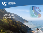
The California Natural Resources Agency released California's Fourth Climate Change Assessment today (Monday, Aug. 27), at http://www.ClimateAssessment.ca.gov. UC Agriculture and Natural Resources scientists contributed substantially to the report.
The Fourth Assessment is broken down into nine technical reports on the following...

- Author: Jeannette E. Warnert
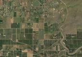
In order to slow global climate change and achieve greater energy independence, Americans are showing an increasing interest in switching over to clean, renewable fuels made from home-grown crops. In fact, Congress has mandated that at least 16 billion gallons of cellulosic ethanol be added to the U.S. fuel supply by 2022.
However, estimates suggest that growing crops to produce that much biofuel would require 40 to 50 million acres of land, an area roughly equivalent in size to the entire state of Nebraska.
“If we convert cropland that now produces food into fuel production, what will that do to our food supply?” asks Maggi Kelly, UC Cooperative Extension...

- Author: Kim Ingram
Because management projects in contentious natural resource contexts often involve finding reasonable compromise or shared understandings between participants, the success (or failure) of such management is partly about communicating information. Techniques for public participation continue to evolve in order to facilitate a more comprehensive flow of information to, from, and between diverse audiences.
The Internet is part of this evolution: web-based tools provide information exchange between diverse participants and stakeholders about complex environmental systems. But how effective are these tools and do they facilitate the flow of information required in adaptive management? Maggi Kelly, UC Cooperative Extension specialist...

- Author: Kim Ingram
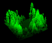
‘Visualizing’ forests from computer and other technological data is common practice in the field of forestry. Forest visualization is used for stand and landscape management and to predict future environmental conditions. Currently, most visualization software packages focus on one forest stand at a time (hundreds of acres), but now we can visualize an entire forest, from ridge top to ridge top. The Sierra Nevada Adaptive Management Project (SNAMP) Spatial Team principle investigators Qinghua Guo, associate professor in the UC Merced School of Engineering; Maggi Kelly, UC Cooperative Extension specialist in the...

- Author: Pamela Kan-Rice

When the great outdoors is your research laboratory, gathering data can be a challenge. To get a broader perspective on the extent of damage caused by sudden oak death, a UC Berkeley Cooperative Extension geographer is using crowd sourcing to enhance her research on the disease that has killed over a million of California’s iconic oak trees since 1995.
Maggi Kelly, UC Berkeley Cooperative Extension specialist, started collecting data from community members through her OakMapper website in 2001. Now she has a mobile application for smartphones.
While out in a park or forest, iPhone users can use the new OakMapper mobile app to report...

