- Author: Brook Gamble

Over a dozen UC Agriculture and Natural Resources (UC ANR) California Naturalists, fire ecology experts, wildlife biologists, resource managers, educators, and artists met at UC Berkeley's Blodgett Forest Research Station and the adjacent El Dorado National Forest April 23 and 24, and not one of them complained about the much-needed deluge of rain and intermittent hail that soaked the group. The weekend's ambitious goal? To dive deeply into a
- Author: Kim Ingram

Because management projects in contentious natural resource contexts often involve finding reasonable compromise or shared understandings between participants, the success (or failure) of such management is partly about communicating information. Techniques for public participation continue to evolve in order to facilitate a more comprehensive flow of information to, from, and between diverse audiences.
The Internet is part of this evolution: web-based tools provide information exchange between diverse participants and stakeholders about complex environmental systems. But how effective are these tools and do they facilitate the flow of information required in adaptive management? Maggi Kelly, UC Cooperative Extension specialist...
- Author: Kim Ingram

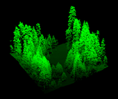
‘Visualizing’ forests from computer and other technological data is common practice in the field of forestry. Forest visualization is used for stand and landscape management and to predict future environmental conditions. Currently, most visualization software packages focus on one forest stand at a time (hundreds of acres), but now we can visualize an entire forest, from ridge top to ridge top. The Sierra Nevada Adaptive Management Project (SNAMP) Spatial Team principle investigators Qinghua Guo, associate professor in the UC Merced School of Engineering; Maggi Kelly, UC Cooperative Extension specialist in the...
- Author: Kim Ingram

UC scientists with the Sierra Nevada Adaptive Management Project (SNAMP) are investigating the uses of Lidar (light detection and ranging) in providing detailed information on how forest habitat is affected by fuels management treatments across a large landscape. Mapping forest structure can illustrate how a forest influences surface hydrology, provides for wildlife and how a forest might burn given certain weather and wind patterns. This research is proving useful in wildlife studies, water quantity and fire modeling and forest planning.
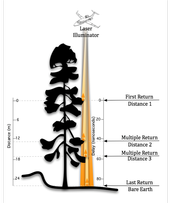
Airborne lidar works by emitting a light pulse from an emitter onboard a plane towards a ground target. A portion of the light is reflected back to...
- Author: Anne Lombardo

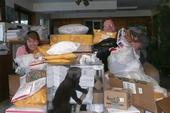
Thank you 185 times over!! The wildlife research team from the Sierra Nevada Adaptive Management Project recently put out a request for the donation of single socks. They use them to hold bait for their camera trap studies of the Pacific fisher. The response was overwhelming and the fisher research team would like to thank all of the people who sorted, dropped off or packaged, waited in line and mailed their recycled socks to them. Your commitment and follow through are remarkable!
The team first got bags of socks from the local high school, and then grocery bags of socks started appearing in a local drop off bin. Soon boxes of socks started arriving by mail. They came from all over...


