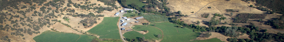

The parcel, which is adjacent to the UC Sierra Foothill Research and Extension Center (SFREC) in Browns Valley, will be managed by UC to protect its natural resources. The transaction closed January 29.
Located on the Yuba River, the Narrows property is 60 miles northeast of Sacramento. UC Sierra Foothill Research and Extension Center has more than 5,700 acres of rangeland for scientists to study critical rangeland issues.

Cattle grazing is a major tool to manage vegetation on rangelands and to enhance rangeland ecosystems. Although the Narrows land is too steep for grazing, it can be used to study a suite of critical natural resource processes.
“This is the first of several land transfers from PG&E to a public agency in the Yuba River watershed and the only in Yuba County,” said Marty Coleman-Hunt, Bear Yuba Land Trust executive director. “It's the culmination of over a decade of planning and work with local conservation groups and the Stewardship Council. The permanent protection of this land below Englebright Dam is critical for the health of the important Yuba River salmon fishery and public recreation for the lower Yuba River.”
“In partnership with the many organizations that make up the Stewardship Council, PG&E is pleased to permanently protect the natural resources and beauty of the Narrows parcel and watershed lands associated with our hydroelectric system for the benefit of current and future generations,” said Mike Schonherr, manager of PG&E's Land Conservation Commitment Department.

The center additionally offers many educational features including a series of nature trails and an education center on the Yuba River, which can be used by schools and community groups for outdoor education and outreach events.
Bear Yuba Land Trust is a non-profit, membership-supported group that promotes voluntary conservation of natural, historical and agricultural resources in the Bear and Yuba watersheds of the Sierra Nevada foothills. Each year, BYLT's stewardship team will monitor the conservation easement at the Narrows for conservation values like documenting the presence of native plants and animals. BYLT will hold the development rights forever, meaning the land will be permanently protected as a natural place and remain undeveloped.
For more information about PG&E's transfer of the Narrows property, visit http://www.stewardshipcouncil.org/land_conservation/planning_units/narrows.htm.
For more information about the UC Sierra Foothill Research and Extension Center, please visit http://sfrec.ucanr.edu.


I'm guessing that only the top photo helps in aiding a visual-image "fix" on the PG&E property. A well-placed arrow would help ,but a better, perhaps an aerial view, would be great.
The term "Whitewater Put-in" on the Narrows Planning Unit Map (App 6) must be a reference to recreational rafting and kayaking accessed through the Narrows by "trespassing" on Department of Defense land(??). (I had the good fortune to participate in such a trip, way back when. It's awesome.)
Perhaps, with some diligence, the SFREC could add "Rafting Down The Yuba" to its "...series of nature trails (A great addition, Doug; you aren't getting the credit you deserve)and an education center."
Jeremy, I searched in vain for a definition of "PH" in the color/icon keys at the bottom of the Appendix 6 Map, and couldn't find it. Do you know what it stands for?
Finally, could you expand on what you mean by "...a suite of critical natural resource processes" that the Narrows land can be used for?
Cuz if they are really critical, lots of folks besides me would be interested in knowing more about them. Research is costly, and the need for new studies should be clearly defined.