In February of 2020, IGIS welcomed a new student worker to the IGIS team. Hannah Lopez, an undergraduate at UC Berkeley majoring in Forestry and GIS, joined IGIS during the final semester of her senior year. As a student, she supported the IGIS Service Center by compiling a database of California field stations, developing future IGIS workshops, and creating custom cartography for IGIS clients. After graduating with a degree in Ecosystem Management and Forestry and a minor in Geospatial Information Science and Technology, Hannah joined IGIS full-time for the summer and fall of 2020.
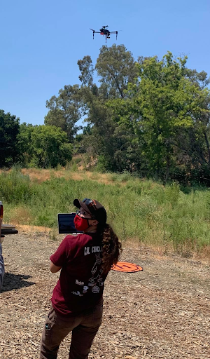
Hannah worked with us on a variety of projects. She helped us with our expanded virtual IGIS DroneCamp 2020, including curating and publishing a YouTube playlist that includes all the workshops, lectures, and guest presentations from the 4 day virtual program. Check it out! She also gained hands-on drone experience while working in Winters, California, on a socially-distanced project with Sean Hogan. They flew the Putah Creek channel to help with a project examining bank erosion over time. See her below in action!
She also collaborated with folks from the California Public Utilities Commission and US Department of Agriculture to develop a web mapping application and story map that highlights areas in California that are eligible for funding assistance for broadband installation. After gaining experience with Esri's new StoryMap Builder while working on this project, Hannah went on to develop custom StoryMap templates for IGIS clients and has developed an IGIS workshop on this topic. Stay tuned!
Hannah is leaving the IGIS team in mid-October to begin her work with the Contra Costa and Alameda County Resource Conservation Districts as a Wildfire Conservation Coordinator. We wish her all the best and look forward to her success in her new job!
Author - Director, Statewide IGIS Program, Professor and Cooperative Extension Specialist
Attached Images:
