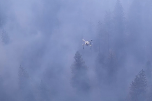
Drone sensors for deployment into a local ignition event Courtesy of Kevin Schwarm
As California and other states continue to battle extreme heat this fire season,KevinSchwarm, who is pursuing a Ph.D. attheUCLASamueli School of Engineering, has been fighting fire with fire alongside other researchersatBlodgett Forest in Northern California.
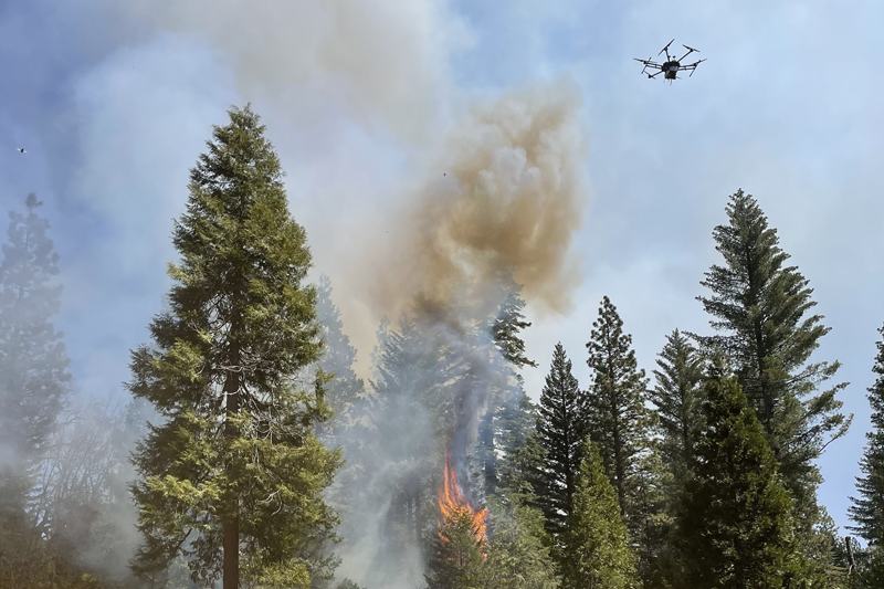
Using new drone sensing technology, Schwarm has helped contribute to a new way of measuring the emissions of fires — carbon monoxide, carbon dioxide, particulates, volatile organic compounds, etc. — so researchers can gain a deeper understanding of the way wildfires behave.
When controlled properly, the so-called prescribed burns — fires that are intentionally set to clear out vegetation that otherwise could end up fueling larger, more catastrophic fires — can play a key role in maintaining the health of a forest. They help prevent the kinds of wildfires that have wiped out homes and caused devastating losses of lives across California in recent years.
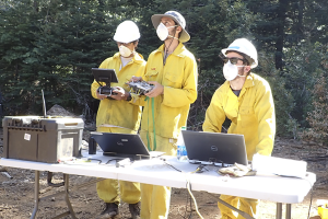
Schwarm (right) monitoring data collection alongside OptoKnowledge engineers
While setting fire to the forest mayseemcounterintuitive to the goal of preventing wildfires, it draws inspiration from Native American practices of setting controlled fires to improve the habitats for deer and other game animals.
Since the Gold Rush, however, the amount of plant life in forests in California has proliferated. While this growth is ostensibly good for the health of the forests, the extra vegetation actually increases the risk of extreme wildfires as it provides large amounts of fuel.
Located about 142 miles east of UC Berkeley on the western slope of the central Sierra Nevada, the 4,400-acre Blodgett Forest Research Station has been a living laboratory since 1933. In April, Rob York, an assistant Cooperative Extension specialist and adjunct associate professor of forestry at UC Berkeley, directed a field campaign involving four days of controlled burns. Scientists and forestry experts from other universities, including UCLA and UC Riverside, joined in the effort to reduce wildfire risk.
Working with engineers from OptoKnowledge, Schwarm was a part of several research teams in charge of measuring the emissions of the prescribed burns. They monitored the emissions using a drone that features on-board, optical sensors that can measure levels of airborne carbon monoxide and carbon dioxide. The team also used the data to create aerial maps that correlate the emissions with the fires, as well as other ground and air measurements.
Schwarm, whose doctoral research focuses on optical diagnostics for combustion systems and harsh environments, was responsible for monitoring the data collection, working with the optical sensor equipment and guiding the drone pilots during the tests.
Drone sensors in action above the prescribed burn at Blodgett Forest
“The objective was to capture as much information as possible on the emissions of these fires and also to relate those to the burned vegetation that was inventoried beforehand,”saidSchwarm, who works in the lab ofMitchellSpearrin, a professor of mechanical and aerospace engineeringatUCLASamueli. “We are hoping that the results of this field campaign will help to further our understanding of wildfire combustion science, the role of wildfires in our local and global climate, and to help us develop more efficient wildfire management strategies.”
A Maine native who loves the outdoors, Schwarm was initially interested in research involving internal combustion engines when he first visited UCLA in 2017 as a prospective graduate student. After meeting Spearrin and learning about his research on laser diagnostics and combustion systems, Schwarm was intrigued and decided to join Spearrin's research group that fall.
“I found Professor Spearrin's research very compelling, with laser diagnostics providing an avenue for engine research while also remaining an elegantly simple yet powerful measurement tool with wide applicability,” Schwarm shared.
Last fall, Spearrin introduced Schwarm to the multicampus wildfire project. “I found it a very exciting opportunity to use our expertise in combustion diagnostics to play a role in enhancing our understanding of both wildfires and climate change, which could lead to better methods for managing these grave issues,” Schwarm said.
According to Schwarm, the preliminary results from emissions data collected during the field campaign indicate that the drone sensor was very effective in capturing the multi-dimensional gradients of emissions in the fire plumes.
The team has been able to create three-dimensional spatial maps of the emissions concentrations, tracking how they change over time. This finding provides the researchers with insight into how fires behave, such as where the boundaries of the fire are and where new ignition sites emerge.
“This is very exciting as a new sensor capability to provide a deeper level of information for a wide range of applications in wildfire science and management, and we are currently working with the other researchers involved in the burns to place that information into context,” Schwarm said. “This was the first full-scale, real-world test for our drone sensor, and it will serve as a strong foundation for future deployment and expansion of our methods.”
The Center for Forestry and Center for Fire Research and Outreach are merging to become Berkeley Forests!
As we all know, forests and fire are inextricably linked in California. Historically, both Centers have carried out research, outreach, and education on human interactions with California ecosystems. Combining the Centers under one roof will facilitate the work of our co-directors, Dr. Scott Stephens and Dr. William Stewart, our Berkeley Forests staff, and management of our new research forest, Grouse Ridge.
To this end, we are proud to release our new website at https://forests.berkeley.edu/ The new website features easy to access information about our forests, fire resources, information on current research, our long-term datasets for our forests, and more.
With these changes, we will also be hiring a new Policy Analyst (located at the Berkeley campus). We seek someone with experience in and knowledge of forests, fire, grant writing, social media, website work, and GIS/data analysis. An official position will be released shortly on the Berkeley jobs website, but please make sure to follow us on social media or email one of or co-directors so you don't miss it!
We're also merging all our social media pages! The Center for Forestry and Center for Fire facebook pages will be closed and transition to the Blodgett Forest Research Station page to become Blodgett Research Station at Berkeley Forests. Please like us at our new home if you have not done so already!
On twitter, the @ucforestcenter page will be closed, and the @ucfirecenter page will become @berkeleyforests. If you are only on the @ucforestcenter, please make sure to change your follow to @berkeleyforests!
Congratulations to ESPM assistant adjunct professor Robert York, who has been awarded the Presidential Field Forester Award by the Society of American Foresters (SAF). York, who serves as the university's research stations manager at the Center for Forestry, works at the intersection of forest science and management. His scientific work explores novel approaches for designing silvicultural treatments in ways that are guided by the natural disturbance regime. As forest manager of a network of research stations in the Sierra Nevada in California, he has the opportunity to apply research to management. His management focus is on applying scientific results and exploring management approaches within an experimental context, striving to apply the principle of active adaptive management to forest management.
Read more about the award and the 2016 recipients on the SAF website.
With the 2014 El Dorado National Forest's King Fire as a case study, a mix of lectures, field studies, art, field journaling techniques, and Native American story telling were used to examine land management practices that influence fire behavior and explore how the landscape recovers from fire. UC ANR Cooperative Extension Central Sierra's forestry advisor Susie Kocher and community education specialist Kim Ingram organized and facilitated the workshop.
Blodgett Forest, situated on the Georgetown Divide in El Dorado County, was donated to the University of California in 1933 to provide a research site and practical demonstrations of forestry for students, forest industry, and the public. The adjacent El Dorado National Forest is home to the notorious September-October 2014 King Fire that burned 97,000 acres of forest, including 63,000 acres of public land. Aided by low relative humidity and wind, the fire spread quickly up the steep Rubicon River and surrounding subwatersheds. According to the incident report, approximately 46 percent of the burn area burned at a high and moderate soil burn severity, consuming all organic duff on the soil surface along with leaves and needles on standing live vegetation.
Workshop participants were treated a lecture and field studies of basic fire ecology concepts by Scott Stephens, professor of fire science at UC Berkeley. Stevens lectured in class, and later demonstrated on a number of wet, lush forested treatment plots in the field, topics ranging from fire policy, fuels management options and objectives, and carbon sequestration to fire suppression consequences, fire behavior and severity, soil stability, and post-fire forest structure. Stephens is a researcher with the Sierra Nevada Adaptive Management Project (SNAMP), a long-term collaborative research project investigating how forest fuels thinning impacts fire behavior, fire risk, wildlife, forest health, and water. Fire is a vital to maintaining healthy California forests and ecosystems and Stephens's work demonstrates that both prescribed fire and its mechanical thinning replacements can successfully change forest structure and fuel loads, resulting in potential overall improvement of forest health. He finds that treated forest stands are more resistant and resilient to high-intensity wildfire and that these treatments have minor to negligible negative impacts on birds and small mammals, understory plant diversity, exotic plant invasions, and insect attack. Current and future research is in part focused on the impact and feasibility of treatments across the landscape.
Also joining participants was Sheila Whitmore from the University of Wisconsin-Madison. Whitmore is the assistant project leader on SNAMP's owl team, which studies how fuel reduction treatments affect California spotted owl survival, forest occupancy, and reproductive success. The California spotted owl is one of three sub-species of spotted owls and the only spotted owl that has not yet been placed on the endangered species list, although its population is widely thought to be declining. Late in the evening, accompanied by Whimore, three nocturnal field technicians, and armed with tools of the trade like bird call whistles and flashlights, participants quietly slogged deep into the forest along the 22-mile system of El Dorado Irrigation District canals, listening for the territorial four-note hoot of the California spotted owl. While the crew eventually found one female owl on the night hike, the owl team has just started surveying breeding territories this spring and are uncertain how and if the owls will be impacted by the King Fire. Modeling efforts and a radio telemetry study seek answers to questions about demography, habitat, individual range size, and foraging preferences, given different levels of severity in burned forests.
Day two of the workshop, under warm sunshine, began with a discussion of Native American fire ecology and traditional stories shared by Kimberly Shiningstar Petree. Petree is a Tumelay Nissenan Miwok, the cultural preservation officer for her tribe, and the founder of the Cosumnes Culture and Waterways, a non-profit dedicated to promoting, preserving, and stewarding Indigenous Culture and waterways of their land. As told by a descendant of the first stewards of the area's forests and a carrier of an ancient oral tradition, the fire stories that Petree shared with the group were both relevant to today's fire management practices, and moving, setting a positive tone for the rest of the day.
Patricia Trimble, El Dorado National Forest's Georgetown district ranger, and Laurie Wigham, illustrator, painter and art teacher, accompanied participants on field activities. Trimble took participants on a road-based tour of the King Fire, demonstrating the effects of low, moderate and severe fire on the landscape. She shared information on consequences of long-term fire suppression, fire impacts, Forest Service strategies for protecting cultural resources, forest replanting and erosion abatement efforts, National Environmental Policy Act regulations, and public perception of fire. More than seven months after the fire, the Forest Service has just opened the burn back up to the public, and the public was out in force mushroom hunting, fishing, and cutting firewood within the high severity areas of the King Fire.
Wigham thoughtfully braided art and field journaling techniques seamlessly into the stops along the way. She shared inexpensive and novel ways to document the landscape in a group or individual setting at difference scales. She offered low-tech tricks to help participants deepen their ability to absorb dense and technical information, observe nature closely and scientifically, and to connect with feelings about a place and time in nature.
Lectures, field study, art, field journaling techniques, knowledge sharing, and Native American story telling: supported by a solid framework of current science topics and research results, they all had their place in this advanced training workshop. Each individual piece of the fire ecology workshop was enriching and informative, and forced participants to move deeper and more thoughtfully into their understanding of the dense topic than they might on their own. The regeneration of the El Dorado National Forest after the King Fire will undoubtedly provide inspiration, research, and education opportunities far into the future.
The UC California Naturalist Program uses a science curriculum, hands-on learning and service to inspire stewardship of the state's natural resources. The public and UC-certified Naturalists alike may sign up for future California Naturalist Advanced Trainings here.
A key University of California, Berkeley, research station is threatened by the King Fire in El Dorado County. Blodgett Research Forest, 4,270 acres located 10 miles east of Georgetown, is home to scores of UC Berkeley investigations on trees and other plants, fish and wildlife populations, insects, diseases, soils, atmospheric chemistry and wildfire management techniques.
Backfiring — controlled burns to contain greater wildfire damage — are expected to begin today (Friday, Sept. 19) on the Blodgett property. The arson-sparked King Fire has burned more than 75,000 acres, triggering evacuations, incinerating trees, and closing Highway 50 and local roads. As of this morning the fire was only 10 percent contained, according to Calfire. University personnel have been evacuated from the research station and UC Berkeley fire experts in El Dorado County and on the Berkeley campus, based at the College of Natural Resources (CNR), are coordinating with the U.S. Forest Service, which manages wildfires in this region, and Calfire on priorities for defending the property.
“With 50 years of annual harvests and 40 years of annual measurements of permanent plots, Blodgett is the Rosetta Stone for the Sierra Nevada with respect to the interactions of forests, management and fires,” said William Stewart, a forestry researcher and co-director of UC Berkeley's Center for Forestry. In addition, Stewart said, the half-century of monitoring gives Blodgett the longest continuous record on forests in the Sierra Nevada.
While the spread of the King Fire to Blodgett would result in a discontinuity in the long-term data collection, it simultaneously would launch the start of data collection on a new continuum—a unique opportunity to learn, fire experts say.
“You'll change that continuous record, but also start a whole new record that reflects the fundamental role of disruptive elements of Sierra ecology,” said J. Keith Gilless, CNR dean and a forest economics professor.
Researchers would also get valuable information on current experiments and hypotheses.
“Our investments in improving forest resiliency will be severely tested if the King Fire enters our property,” Stewart said. “We will find out how effective those investments have been.” For example, effectiveness of vegetation treatments, such as cutting low brush and young trees, or creating patchworks of smaller clear-cut areas, will be tested in a more severe way than is possible under normal research conditions.
“You never say, ‘let's light a really, really hot fire and see how the stand holds up,'” said Gilless. “But you can go in and do analysis after an event like this: We hypothesized these treatments would be effective; do they actually deliver when put to the test by an uncontrolled wildfire?”
Scientists are already preparing to collect data—soil samples, tree mortality rates, information on char height (burns to the trunks) and scorch height (burns to the treetops)— both to understand how the fire burned and increase the potential to bring back a healthy forest.
Not every tree dies in a wildfire. But damaged trees become more susceptible to pests and pathogens, which can kill them or inhibit the growth of other vegetation. “We can measure the potential resilience of a forest by understanding the level of damage and mortality, and how our forest-management practices influenced those outcomes,” said fire science professor Scott Stephens.
The researchers say it's also opportunity to employ adaptive management, a forestry best practice that involves learning from the results of each fire, analyzing what worked, what didn't, and why; and then applying those lessons.
With the fire advancing and Blodgett in an area currently slated to be allowed to burn, researchers are scurrying to organize their efforts.
“Unlike much of the research we do, an event like this imposes its own timetable. You have to deal with it in real time,” Gilless said. And while collective fingers are crossed that Blodgett will survive, Berkeley's fire researchers must prepare for any outcome. “Everything that transpires in nature is an opportunity to learn,” added Gilless.
A trove of past — and future — data
The research station is located in an area where danger posed by severe wildfires is very high. For the past two decades it has been a center for UC Berkeley research projects that evaluate the effectiveness of treated plots against control plots—unmanaged ecological reserves.
The findings from this research have already had broad impacts on how fires are managed locally, statewide, nationally, and internationally. Data gathered at Blodgett have helped scientists, forest managers, and fire experts understand: • How different forest and fuel management techniques work over time; • How forest management approaches affect biodiversity; • How processes like nutrient cycling and carbon cycling actually operate in forests.
For example, biodiversity studies showed that a mosaic of tree sizes and openings create more habitat niches for birds and animals. Fuel treatment studies have show that reducing tree and shrub densities increase the probability that medium and large size trees can survive wildfires.
Stephens, whose recent research includes thinning young forests to reduce fire risk and greenhouse gas emissions, says the King Fire is a symptom of California's larger forest problem.
“Almost all of the Sierra Nevada is in a state of high fire hazard because of past fire suppression, and harvesting that focused on large trees,” a practice that left the more susceptible smaller trees and debris, increasing fuel loads. “It will take decades of active management to reduce hazards and produce resilient forests,” Stephens said. “This will not be easy but it is possible. If we don't get this work done, future generations will not enjoy forests as we have, and forests will be fundamentally different, with much more severe wildfire impacts. ” Related Links