Posts Tagged: Avian influenza
Poultry owners urged to protect birds from avian influenza virus
A strain of highly pathogenic avian influenza is currently infecting and killing wild birds and domestic birds in at least 29 states across the United States.
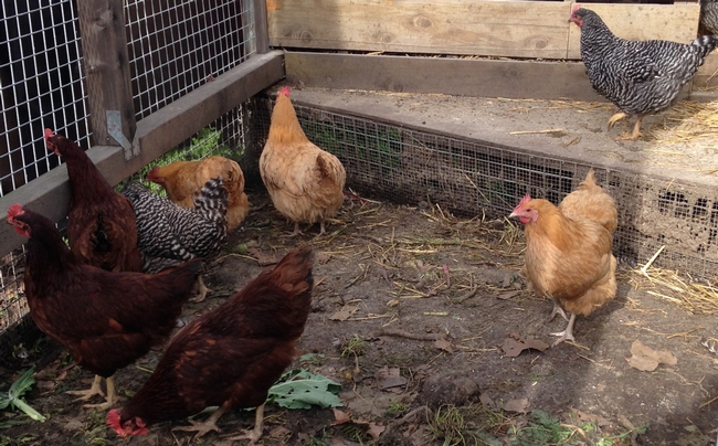
A UC Agriculture and Natural Resources poultry expert urges commercial and backyard chicken owners to take precautions.
“When it comes to protecting your flock, there is no treatment for HPAI so the best thing you can do is focus on biosecurity,” said Maurice Pitesky, UC Cooperative Extension poultry specialist in the School of Veterinary Medicine at UC Davis.
“In order to protect our commercial and backyard chickens, it is essential for all of us who own poultry to do our part,” he said.
The current avian influenza outbreak is already considered the worst bird flu outbreak since the 2015 HPAI outbreak when nearly 50 million poultry were euthanized or died.
The HPAI virus is being spread by migrating birds and California is part of the Pacific migratory flyway.
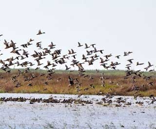
“Waterfowl migrate thousands of miles between wintering and breeding locations and have long been known to be the natural reservoirs for avian influenza viruses, which are associated with high mortality in poultry,” Pitesky explained. “Many of these migrating ducks, geese and swans winter in the relatively warmer climate of California's Central Valley among other locations where they can find appropriate habitat.”
Pitesky recommends preventing chickens and other poultry from exposure to waterfowl and other potential wild bird carriers.
“At the most generic level, that means making sure your birds are separated from any wildlife,” he said. “Whether you have a million-bird farm or just a few backyard chickens, the message is the same: maintain the best biosecurity you can, which includes fencing and make sure you reduce reasons for waterfowl to come near your birds such as spilled feed and ponding of water.
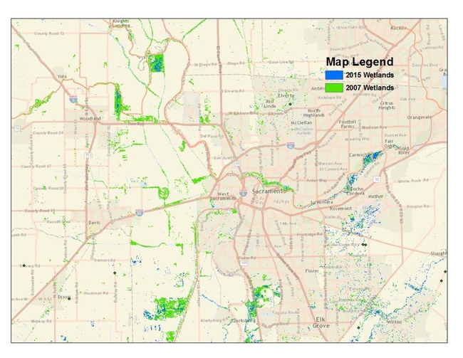
“Our previous research has shown that waterfowl are attracted to both natural and human-made wetlands and lagoons. So, if you live near one of these types of habitats, your biosecurity efforts are even more important.”
The HPAI virus does not currently affect humans. Pitesky said it is important to recognize that avian influenza viruses, like all viruses, can mutate or recombine to form new versions of virus that may affect humans.
For more information on biosecurity and where HPAI has been identified in the U.S., please visit the UC Cooperative Extension poultry website at https://ucanr.edu/sites/poultry/Resources_335/HPAI.
Poultry owners who have questions may reach Pitesky at mepitesky@ucdavis.edu.
New California Waterfowl Tracker website launched to help poultry producers assess bird flu risk
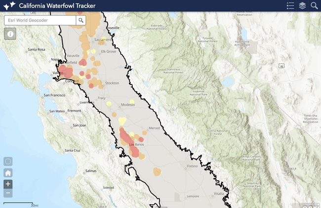
To reduce potential exposure to avian influenza, a new interactive website is now available to help California poultry producers, backyard poultry enthusiasts, regulators and risk managers assess the locations of waterfowl relative to poultry farms in the Central Valley.
While not all waterfowl carry avian influenza, the migratory birds are the primary reservoir of the virus that kills chickens, turkeys and other birds and can take an economic toll on the poultry industry. During an outbreak of a highly pathogenic strain of avian influenza in 2014-15, nearly 50 million birds had to be killed to contain the disease in the United States.
“Avian influenza is such a devastating disease, in an abundance of caution, we want to limit any interaction between waterfowl and domestic poultry,” said Maurice Pitesky, UC Cooperative Extension poultry specialist.
The California Waterfowl Tracker has been developed by Pitesky at the School of Veterinary Medicine at UC Davis, the University of Delaware, U.S. Geological Survey and UC Agriculture and Natural Resources to show where waterfowl are.
From September through March, geese, ducks and other waterfowl migrate by the millions via the Pacific Flyway and winter in California wetlands, rice and corn fields. At the height of migration, the Central Valley is home to 3 million waterfowl.
The Central Valley is also home to the majority of the state's commercial egg-laying hens, broiler chickens and turkey flocks.
Using the web app to understand when and where waterfowl are feeding and roosting, poultry farm managers and other stakeholders will be able to consider waterfowl in their decision making. They may decide to place pasture-raised poultry in a region of the state that has less wetlands, such as Fresno. If a large number of Canada geese take up residence nearby, poultry owners may decide to move their domestic birds indoors to reduce their exposure until the migrating waterfowl move on.
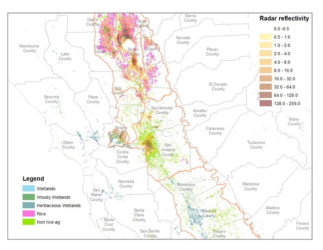
Using a machine-learning approach developed by Jeff Buler, University of Delaware wildlife ecology professor, the web app produces a waterfowl density map of California's Central Valley that is automatically updated daily with both satellite and weather station information.
“The model doesn't tell us whether waterfowl are carrying avian influenza, but it helps poultry producers and regulators understand where those interfaces could happen,” Pitesky said.
Additional waterfowl habitat and next-generation radar analysis of waterfowl are integrated into the web app. Users can search one or more addresses to anticipate their farms' interaction with waterfowl. Based on the proximity of waterfowl and wild bird monitoring information from the U.S. Fish and Wildlife Service, poultry owners can make biosecurity decisions.
“While the current version of the website is designed for California, the long-term goal is to develop and expand this system for the continental U.S. to promote health and safety of poultry flocks nationally,” Pitesky said.
To use the California Waterfowl Tracker, visit the UC Cooperative Extension Poultry website http://ucanr.edu/sites/poultry. A video of Pitesky demonstrating how to use the web app can be viewed at https://youtu.be/EOO0Q_ggZ9I.
Poultry producers who would like to be notified by UC Cooperative Extension if there is an avian influenza outbreak in their area can sign up on the California Poultry Census page at http://ucanr.edu/sites/poultry/California_Poultry_Census.
Protect your poultry from avian flu
University of California poultry experts are urging poultry owners to examine biosecurity for their flocks after avian influenza was confirmed in commercial chickens in Tennessee by the USDA Animal and Plant Health Inspection Service on Sunday (March 5). To protect the birds' health, UC scientists recommend taking measures to prevent poultry from coming into contact with wild birds.
"Based on the initial sequence of the virus, the source of the virus is thought to be waterfowl, said Maurice Pitesky, UC Cooperative Extension poultry specialist in the School of Veterinary Medicine at UC Davis. “This is consistent with the current understanding of how avian influenza spreads and evolves. Specifically, juveniles are infected at breeding locations and travel south in the fall carrying virus. As the waterfowl move southward, they are more likely to interact with other species, increasing the risk of interspecies transmission and formation of new varieties of avian influenza.”
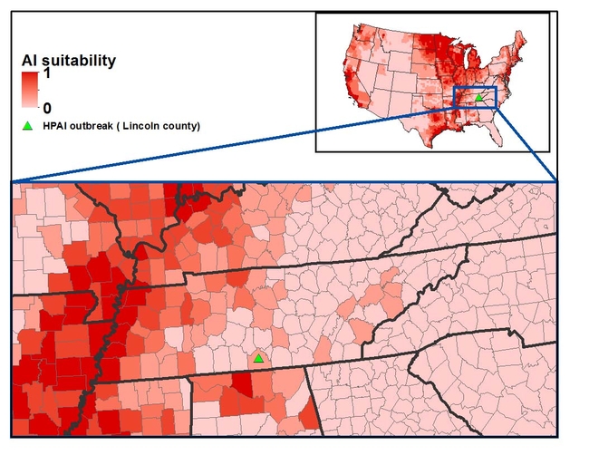
The case in Lincoln County, Tenn., is the first report of highly pathogenic H7 avian influenza in commercial poultry in the United States this year. The flock of 73,500 affected chickens is located within the Mississippi Flyway, one of four North American flyways for migratory birds.
“Lincoln County is located in one of the medium-high risk areas that were identified by our risk map, said Beatriz Martínez López, director of the Center for Animal Disease Modeling and Surveillance in the School of Veterinary Medicine at UC Davis.
“We need to increase awareness of poultry producers to maximize the biosecurity implemented in their operations, particularly in those located in high risk areas, mainly farms that are in close proximity to wetlands or other wild bird feeding and resting areas,” said Martínez López.
Poultry owners can identify biosecurity strengths and weaknesses for their own farm or backyard flock by filling out a free survey designed by Martínez López and other poultry experts. People who raise chickens, quail, ducks, turkeys, geese or other birds anywhere in the United States are invited to use the resource. At the end of the survey, participants receive specific research-based recommendations of biosecurity measures they can apply on their own types of farms. The poultry biosecurity survey is available in English http://bit.ly/2kkMycf and Spanish http://bit.ly/2mjO13G. The survey takes 15 to 20 minutes to complete and will be open until June 1.
If you would like UC Cooperative Extension to notify you if there is an avian influenza outbreak in your area, sign up on the California Poultry Census page: http://ucanr.edu/sites/poultry/California_Poultry_Census.
Owners of backyard chickens who observe illness or increased mortality among their birds should call their veterinarian or the California Department of Food Agriculture sick bird hotline at (866) 922-BIRD (2473).
For more information about raising poultry, visit http://ucanr.edu/sites/poultry.
Are your birds safe from avian influenza?
To prevent outbreaks of this highly contagious virus in the United States, commercial and backyard poultry owners are being asked to fill out an online biosecurity survey. UC Agriculture and Natural Resources and UC Davis researchers are studying poultry-raising practices to help strengthen the industry's defenses against avian influenza.
“With changing migration patterns of wild birds and global movements of poultry, there is an urgent need to develop plans to protect U.S. poultry against highly pathogenic avian influenza,” said Beatriz Martínez López, director of the Center for Animal Disease Modeling and Surveillance in the School of Veterinary Medicine at UC Davis.
People who raise chickens, quail, ducks, turkeys, geese or other birds anywhere in the United States are invited to fill out the survey.
“We want to hear from all poultry producers: from the large commercial farms producing chicken eggs to the poultry enthusiasts who raise a few ornamental show birds in their backyards,” said Martínez López, who is part of the University of California's Agricultural Experiment Station.
The survey asks which bird species are being raised and a few flock management questions. Is the flock is housed or kept outdoors? How often do you get new birds? What is the source of new birds? It also asks questions about location, such as the distance of the birds from ponds and other bodies of water that may attract migrating waterfowl.
Immediately after completing the online survey, participants receive a biosecurity score and recommendations to help them make more informed decisions.
“Each producer will receive their own biosecurity score and customized recommendations,” Martínez López said. “Recommendations highly depend on the production system and we tried to adapt them to make the changes easier to implement for individual flocks.”
The survey data will be confidential and only summaries will be made publicly available in research reports and peer-reviewed publications.
By analyzing biosecurity and management practices on poultry operations and backyard flocks, Martínez López and visiting professor Sharmin Chowdhury will be able to identify high-risk locations and time periods for avian flu outbreaks. The information will be used to develop biosecurity education programs for poultry farmers, backyard producers and poultry veterinarians.
The survey takes about 15-20 minutes to complete. To participate, take the survey in English http://bit.ly/2kkMycf or Spanish http://bit.ly/2mjO13G by June 1.
This study is funded by Agriculture and Food Research Initiative Competitive Grant no. 2015–09118 from the USDA National Institute of Food and Agriculture.
[This news release has been updated to extend the survey deadline from March 1 to June 1 and to include a link to the survey in Spanish.]
MEDIA CONTACT:
Beatriz Martinez López, DVM, beamartinezlopez@ucdavis.edu, (530)752-7675.
Weather radar helps researchers track bird flu
The same weather radar technology used to predict rain is now giving UC researchers the ability to track wild birds that could carry the avian influenza virus. Avian influenza, which kills chickens, turkeys and other birds, can take a significant economic toll on the poultry industry. In 2014- 2015, the United States experienced its worst bird flu outbreak in history, resulting in more than 48 million birds dying in 15 states, including California.
“We use the existing network of weather radar stations in the U.S. in the same way that radar is used to track rain, except that we process the data to allow us to interpret the radar signal bouncing off birds instead of raindrops,” said Maurice Pitesky, UC Cooperative Extension poultry specialist. “The data can be interpreted to track birds.”
NEXRAD, or next-generation radar, is a network of 160 high-resolution S-band Doppler weather radars operated by the National Weather Service. The technology works best for tracking birds in the winter during feeding. When waterfowl leave their roosting locations in concert to feed, their bodies produce reflectivity of the radar beam.
“By tracking mass bird movements remotely in real-time, we hope to gain novel strategic insights with respect to surveillance and prevention of avian influenza transmission to domestic poultry,” said Todd Kelman, a veterinarian and engineer who co-leads the project with Pitesky, who is also in the School of Veterinary Medicine at UC Davis. They are exploring how the information might be used to prevent an outbreak.
In California, waterfowl migrate by the millions from September through March via the Pacific Flyway, where they winter in wetlands, rice and corn fields. The Central Valley alone is home to 3 million waterfowl at the height of migration.
“Using NEXRAD and various other approaches, we hope to be able to produce monthly or quarterly maps that will alert poultry producers as to the locations of waterfowl in the Central Valley of California,” Pitesky said.
“Waterfowl populations can have different habitat based on the amount of precipitation in a given year,” said Pitesky. “Therefore, we need to use these types of monitoring tools to understand where waterfowl are located. Landsat, or satellite-based land imagery, and NEXRAD are two remote tools that may be very useful, as opposed to flyovers and banding, which are more expensive and not practical for large geographical areas.”
The project — funded by UC Agriculture and Natural Resources — is a collaboration between UC Davis School of Veterinary Medicine and Jeff Buler, University of Delaware wildlife ecologist whose team first developed the NEXRAD approach in the Central Valley of California. They are also working with the U.S. Geological Survey, the California Department of Food and Agriculture, the California Poultry Federation, the Pacific Egg and Poultry Association and Point Blue, an organization that focuses on conservation science.

