
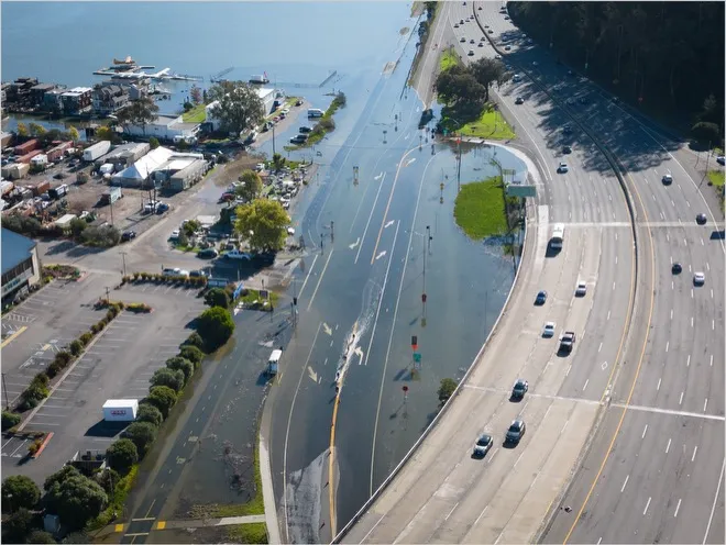
King tide flooding in northern California in January 2023. High sea levels during El Niño may combine with king tides and other land-based flood drivers to increase the extent of coastal flooding. Source: California King Tides Project, 2023.
With a strong El Niño already underway, attention is turning to the increased likelihood of flooding across California. Along the coast, that risk may be particularly high because El Niño influences multiple land- and ocean-based flood drivers at the same time. When these drivers coincide, compound coastal flooding can occur. What drives compound coastal flooding and how might El Niño affect these drivers this winter?
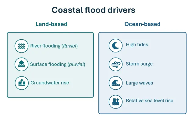
Overview of land- and ocean-based processes that can contribute to compound coastal flooding hazards.
What are compound flood events?
Compound events occur when multiple drivers of flooding occur in the same place, at the same time, or in sequence to increase risks. Their combined effects can be much greater than those of any individual driver. Our current hazard risk-management tools underestimate the impacts of such floods because they often evaluate drivers independently.
For El Niño, added risk comes from several flood drivers shifting at the same time. Along the Central Coast, for instance, El Niño events are associated with higher sea levels, larger wave heights, and heavier precipitation, with coastal erosion and storm damage three times more likely. The National Oceanic and Atmospheric Administration (NOAA) currently estimates a 75% chance that El Niño will reach a historic strength this fall, exceeding previous events dating back to 1950.
How does El Niño change drivers of flooding?
El Niño events vary in intensity, ranging from weak to very strong. On land, strong El Niño events are much more likely to bring more rainfall across California, especially in central and southern regions of the state, increasing land-based flood risk. El Niño also favors more frequent extreme precipitation events. Notably, the very strongest El Niño events, like the potentially historic event predicted for 2026-2027, can expand the northward extent of increased heavy rainfall and associated fluvial and pluvial flood risk to include most, or even all, of northern California. With wetter conditions extending farther north, the significant relationship between El Niño and stream flooding observed historically in coastal Southern California is likely to be relevant across the state this winter. The duration of this El Niño may also matter. Events in which warm eastern Pacific conditions persist into spring have been associated with some of California’s wettest winters and springs on record.
In the ocean, El Niño can raise coastal sea levels in several ways. One important process is coastal trapped waves, which often raise sea levels by 6 to 12 inches for weeks or longer. Local winds can either strengthen or weaken the resulting rise in sea level. El Niño has also been tied to significant increases in wave height. Large waves and storm surges (the temporary rise in sea level during storms) regularly occur together. Along the northern and central California coast, about 30% of extreme storm surge events also bring extreme waves, compared with about 12% to 22% farther south. During extreme storm surge events, which generally happen once or twice per winter, sea levels rise by roughly 7 to 19 inches along the California coast. About 75% of extreme storm surge events last longer than 12 hours, increasing the likelihood of co-occurrence with other flood drivers, such as high tides. In particular, king tides, which are the highest high tides of the year due to the sun, Earth, and moon’s alignment, already cause extensive flooding across low-lying coastal regions of California. Statewide king tide periods this upcoming winter are expected November 24-26, December 23-25, and January 21-22, although exact timing and height vary along the coast. When storm surge or extreme waves occur near high or King tide, their combined effects can raise total water levels above local flood thresholds.
Groundwater levels are also affected by El Niño-driven changes in both land- and ocean-based forcings. While groundwater in California is often discussed in terms of overpumping challenges, some coastal areas have shallow groundwater tables that respond directly to changes in sea level. Groundwater levels can also rise as rainfall percolates into the ground and raises the water table, with strong El Niño events increasing the likelihood of wetter conditions in California. In Imperial Beach, for example, tides cause groundwater levels to fluctuate by over 3 feet, while non-tidal changes in ocean level and recharge from rainfall can each contribute about 1 foot of additional variability. If the water table rises high enough, groundwater can emerge at the surface and flood roads and other low-lying areas.
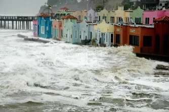
Compound coastal flooding in central California due to a large swell and stormy conditions during the 1982-1983 El Niño. Source: USGS, 2005.
Do compound flood drivers occur during past El Niño events?
Compound flooding has occurred during past El Niño events, but past events are not a perfect prediction for what might happen this winter. Today’s sea levels along the California coast are roughly 3-4 inches higher relative to the 1980s. Past events show how damaging conditions can become when land- and ocean-based flood drivers coincide, and what that could mean for coastal communities this winter.
The 1997-98 El Niño, one of the strongest on record, is a good example. By late 1997, sea levels along the Central Coast were estimated to be roughly 14 inches higher due to warming and elevated water levels arriving from the tropical Pacific, not including contributions from storms, tides, or other types of waves. During a February 1998 storm, observed sea levels in the San Francisco Bay region rose nearly two feet above the predicted tide. That winter had hundreds of millions of dollars in flood and storm damage across the San Francisco Bay region.
During the exceptionally wet El Niño of 1982-83, rainfall totals approached 200% of normal in some regions, and maximum wave heights exceeded 25 ft, unusually high compared with typical annual maxima over a 16-year record examined. Even during the recent 2015-16 El Niño, when California received much less precipitation than during the 1982-83 and 1997-98 events, coastal areas still experienced wave energy about 50% above normal and increases in coastal sea levels of about 0.2 to 0.6 ft (2.4 to 7.2 in).
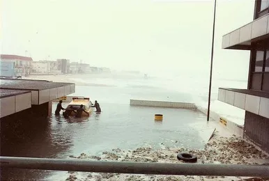
Compound coastal flooding in southern California due to a large swell coinciding with high tide during the 1982-1983 El Niño. Source: Los Angeles County Lifeguards, 1982.
Beyond El Niño, flood risk also includes other important considerations. Impervious surfaces can increase runoff and flood risk in highly developed coastal areas, while high coastal water levels can reduce stormwater systems' capacity to drain. Past disturbances can also affect flood risk. Wildfire, for instance, can change how water moves on hillslopes, increasing runoff in burned watersheds. Research suggests that the Central Coast may show the greatest susceptibility to the compounding effects of wildfires and floods, with each additional preceding wildfire associated with nearly 10-fold greater flood property damages, on average. With multiple major fires, including the Plaskett and Timber fires, recently burned areas along the Central Coast may be especially susceptible to flooding and debris flows this winter. Flooding also depends not only on the storm itself, but also on the conditions leading up to it. As soils become saturated and rivers rise, subsequent storms can more readily lead to flooding.
What can you do?
As we head into winter, water and emergency planners in the state are gearing up for the potential effects of El Niño, and we can all take action to be prepared. Flood risk is elevated along California’s coast this winter, but impacts will vary depending on how storms, tides, waves, and other conditions line up. Being prepared now can make the difference in the future.
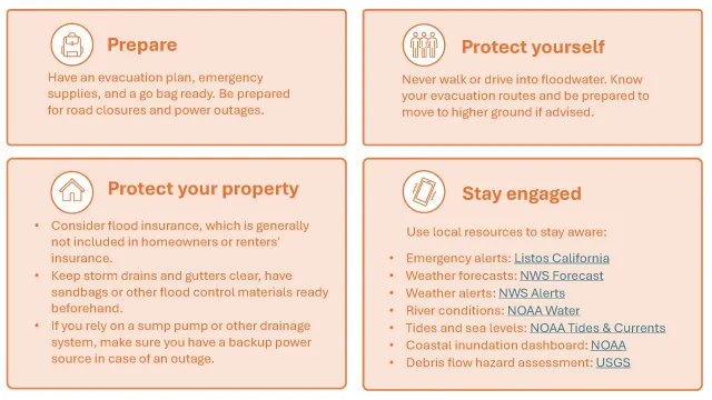
Links:
- Emergency alerts: Listos California
- Weather forecasts: National Weather Service (NWS) Forecast
- Weather alerts: National Weather Service Alerts
- River conditions: NOAA Water
- Tides and sea levels: NOAA Tides & Currents
- Coastal inundation dashboard: NOAA
- Debris flow hazard assessment: USGS
Christina Richardson is an Assistant Professor of Cooperative Extension in Coastal Hydrology, Agriculture, and Water Resilience with UC Agriculture and Natural Resources and the Department of Earth and Planetary Sciences at UC Santa Cruz.
Acknowledgments: Thank you to Erik Porse and Daniel Swain for their helpful input on this article.