Posts Tagged: Land
Exploring the complexities of cannabis farming in rural areas

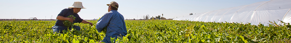
Land use change in agricultural frontiers can have far-reaching social and environmental implications, such as habitat loss, water contamination, or worker demographic shifts — particularly when it involves the rapid expansion of a new industry such as cannabis production. A recent study published in Landscape and Urban Planning offers an interdisciplinary perspective on the drivers of cannabis production in rural areas, using interviews with farmers and spatial modeling to uncover key factors.
Led by researchers from UC Berkeley's Department of Environmental Science, Policy, and Management (ESPM) and the Cannabis Research Center, the article “Where money grows on trees: a socio-ecological assessment of land use change in an agricultural frontier” provides a social-ecological systems approach for assessing drivers of cannabis production in Southern Oregon, using interviews with farmers and spatial modeling to uncover key factors.
"Unlike other crops, we have less understanding of where and how cannabis is grown, making it an important area of ongoing research," said Van Butsic, a professor of cooperative extension in ESPM and the senior author of the study.
The researchers interviewed 14 cannabis farmers to identify major themes around their relationships with land use, and used those themes to generate predictors for models of land use change. Most of the interview-derived drivers were significantly associated with cannabis distribution and development, including parcel size, human footprint, distance to the nearest cannabis farm, the density of local cannabis production, clearable land cover, farm zoning, elevation, roughness, and distance to rivers. The interview data also provided insights into the relationship of cannabis with social and environmental dynamics.
“We gained many insights from the interview data,” said lead author and ESPM postdoctoral scholar Phoebe Parker-Shames. “For example, we knew from previous research that cannabis development tends to be clustered, but we understand a little better now that this is related to the ways in which cannabis farmers rely on each other to share knowledge, labor, and navigate uncertainty during difficult policy changes.”
One of the major themes that emerged from the interview data was the environmental stewardship values of the farmers. “There is a large untapped potential for education and management outreach to target farmers who got into this industry in part because of their ability to connect with the land,” Parker-Shames said. “The farmers we spoke to had a genuine desire to learn best practices in an industry without a lot of formal standards for production. I'm grateful that they were willing to share their experiences and insights with us.”
Additional Berkeley co-authors include ESPM professor Justin Brashares and alumni Hekia Bodwitch (PhD '17 ESPM). The study's findings provide valuable insights into the drivers of cannabis production and the environmental stewardship values of cannabis farmers, which can inform environmental policy, regulation, and best practices for sustainable cannabis production.
Hopland Research and Extension Center's land and cultural history

Field research in agricultural and natural resource science has been ongoing at UCANR Research and Extension Centers for over 70 years, making an impact on the food we eat and the management practices we recommend. What afforded us the opportunity to have these living laboratories? The University of California is a land grant institution and is directly linked with the federal Morrill Act of 1862, also known as the Land-Grant College Act. The Act granted land mostly taken from indigenous tribes to states that used the proceeds from the sale of these lands to fund colleges specializing in agriculture and the mechanical arts.
A recent article in High Country News, "Land-Grab Universities," provides interactive spatial data revealing the direct connection between the ~10.7 million acres of stolen Indigenous land and land-grant institutions. Many of these Morrill Act parcels were in California and, thanks to Andy Lyons at UCANR IGIS, we can view the overlap between UC land and these parcels in a geographic information system.
We created an ESRI Story Map to provide a synoptic history of the land that Hopland Research and Extension Center (HREC) currently occupies before it became part of the University of California. The map is the result of a collaborative effort that included the UC ANR Native American Community Partnerships Work Group, the Tribal Historic Preservation Officer for the Hopland Band of Pomo Indians, HREC staff, local long-time residents, and UC ANR IGIS. Our hope is that educators, researchers, landowners and other Hopland community members will learn about the historical context of the area, including injustices Indigenous people endured, and develop a sense of appreciation and admiration for the land we study.
This story map builds on an acknowledgment of the Shóqowa and Hopland People on whose traditional, ancestral and unceded lands we work, educate and learn, and whose historical and spiritual relationship with these lands continues to this day. It contains some details on the Indigenous history, a brief history of the Spanish/Mexican land grant and other facts from the early colonial period, a timeline of notable events, and ways HREC and neighboring Indigenous communities are collaborating to foster a sincere and mutually beneficial relationship for the land and the community. Please explore HREC's land history story map and if you are interested in building your own see our methods in the reference section.
Officials release new weevil to battle yellow starthistle
In April 2021, scientists released weevils from the Mediterranean region of Europe at the Bureau of Land Management Magnolia Ranch day-use area in El Dorado County to join the battle against yellow starthistle. Yellow starthistle rosette weevil is a newly approved natural enemy of yellow starthistle, which was introduced in California more than 150 years ago and, with no natural enemies in its new location, became one of the state's most harmful weeds, infesting nearly 15 million acres.
")
In California, yellow starthistle can grow to shoulder height, forming massive, thorny patches that block hiking trails, crowd out native plants and present a wildfire danger. The plant is toxic to horses and its flowers are encircled by inch-long sharp spines that can pierce the eyes of grazing animals.
UC Cooperative Extension has worked for decades with landowners to manage yellow starthistle-invested land.
“Over the years, we have developed effective control strategies for yellow starthistle – including well-timed mowing, grazing, hand pulling, burning, cultivation and herbicide application,” said Scott Oneto, UC Cooperative Extension natural resources advisor in El Dorado County. “But these treatments are rarely implemented on a scale large enough to combat our enormous starthistle infestations.”
Efforts to introduce natural enemies from yellow starthistle's home range began in the 1960s. Several species were released to attack starthistle flower heads. These insects lay eggs, hatch and feed on developing seeds, reducing seed production.
“Although the flower head insects sometimes attack high proportions of flowers, yellow starthistle is a very prolific seed producer with an individual plant producing as much as 100,000 seeds,” Oneto said. “Even if the insects reduce seed production by 50%, that still leaves a lot of seeds.”
")
The newly introduced yellow starthistle rosette weevil, first collected in Turkey as a prospective biocontrol agent in 1984, attacks the plant at the base. Since 2001, United States Department of Agriculture research entomologist Lincoln Smith has studied the insect at the USDA Agricultural Research Service laboratory in Albany.
“Larvae of the weevil develop and feed inside the root crown during spring, adults emerge in June, and then they spend the rest of the year hiding,” Smith said. “There is only one generation per year, so populations will grow slowly, which will gradually reduce yellow starthistle populations.”
The weevil presents no risk to other plants in California except bachelor's buttons, which is an introduced plant from Europe, but not considered a noxious weed. Successful biological control with the weevil is expected to reduce yellow starthistle, but not completely eliminate the weed.
This was the second release of the beneficial insect in North America. The first release occurred in Solano County in April 2020.
Bureau of Land Management and University of California Cooperative Extension researchers will be monitoring the Magnolia Ranch site intensively over the next several years to determine the rate of rosette weevil reproduction and efficacy at feeding on yellow starthistle.
For more information, see A New Warrior Released in the Battle to Control Yellow Starthistle by Scott Oneto on the UC Weed Science blog.
")
CalLands maps cropland ownership across California
Two UCANR Cooperative Extension specialists have recently launched CalLands, a powerful online tool that can help users understand how land ownership impacts California's croplands.
To build the CalLands' interactive website, Luke Macaulay and Van Butsic — both assistant UC Cooperative Extension specialists based in UC Berkeley's Department of Environmental Science, Policy, and Management — combined satellite-generated maps of land cover created by the U.S. Department of Agriculture with publicly available land ownership records. Next, they anonymized ownership identity and pulled data from all 58 California counties to include parcels of land larger than five acres. The result is a database that features 543,495 privately-owned properties across the state, creating a data-rich map of crops and ownership boundary lines in every county. The interactive map can be filtered by county to display characteristics of land ownership, percentages of private and public ownership, breakdowns by crop-type, and summaries of land-use statistics.

CalLands allows users to explore how crops are distributed within a county or across the state or understand how ownership size impacts how land is used. In a 2017 study on cropland ownership published in California Agriculture, Butsic and Macaulay discovered that the largest five percent of properties account for 50 percent of California cropland. The two created CalLands with the aim of helping a wide variety of stakeholders understand land cover and land use at the county and individual land ownership scale.

“CalLands helps expand people's understanding of the landscape and how farmers across the state are using their land,” Macaulay says.
The website tells the story in visual terms of the location of key crops over time, including water-intensive plants like alfalfa and almonds, and illustrates the locations and acreages of both annual and perennial crops. This information may be useful for those seeking to understand agricultural water use and expansion and change of crops over time. The team hopes that the tool will also help scientists conduct research that is beneficial to many agricultural stakeholders, such as UC Cooperative Extension specialists creating outreach programming, county officials proposing regulations, and resource managers hoping to understand cropland production.
Currently, CalLands features cropland data from 2013-2017, allowing users to toggle between these annual datasets. Macaulay and Butsic plan for future versions of CalLands to include the capability of producing graphs to help users understand how crop planting changes over time as farming shifts and land changes hands. “We look forward to adding more features to CalLands,” Butsic said. “We want to implement changes on the site based on what Californians need.”
New project to build climate resilience through improved land management

A $4.6 million grant to UC Merced and UC Irvine will help UC Agriculture and Natural Resources researchers develop new tools and methods for California land owners to better manage the state's forests, shrub lands and grasslands.
California's Strategic Growth Council agreed to fund the Innovation Center for Advancing Ecosystem Climate Solutions, a three-year program co-led by UC Merced Professor Roger Bales and UC Irvine Professor Michael Goulden. The money comes through California Climate Investments, a statewide initiative that puts billions of cap-and-trade dollars to work
The goals include reducing wildfire risk, improving long-term carbon sequestration and bolstering resilience in the face of climate change, with an emphasis on California's rural regions and low-income communities.
“Our part of the project is to work with stakeholders and identify areas where we can focus management practices to promote healthy forests, minimize wildfires, improve water security and increase carbon sequestration,” said Toby O'Geen, UC Cooperative Extension soil resource specialist at UC Davis.
“Right now, many of California's forests, shrub lands and grasslands are carbon sources, and we need to change them into carbon sinks,” said Bales, director of the Sierra Nevada Research Institute and distinguished professor of engineering. “Our research will address information bottlenecks to guide decision making, build local capacity for science-based land management and develop methods for translating benefits of land restoration into financing for land restoration.”
California's recent drought, tree die-offs, wildfires and rising temperatures all point to the necessity of improved forest stewardship, Goulden said.
“Officials in the state government and agencies recognize this need, but uncertainty over how to proceed has sometimes slowed progress,” he said.
Most of the work will be conducted by scientists at Merced and Irvine, but collaborators from UC Berkeley, UC Davis, Stanford University, San Diego State University and the University of California Division of Agricultural and Natural Resources, as well as state agencies, will play important roles.
“This research will enable UC Cooperative Extension advisors to provide better advice to land managers to reduce the severity of wildfires,” said Glenda Humiston, UC vice president for agriculture and natural resources. “Severe wildfires are not only releasing greenhouse gases, but polluting the air of many communities, aggravating the health of people in less-affluent, inland areas such as Tulare, Yuba and Mariposa counties.”
At UC Merced, an interdisciplinary group of researchers from two departments — Civil & Environmental Engineering and Management of Complex Systems — will collaborate with UC Cooperative Extension and engage with local stakeholders. The group will study and identify the most-effective land-management practices, in terms of water conservation, forest health, fire resistance and carbon capture.
“We will develop the spatial data and analysis tools to plan landscape restoration, develop local capacity for better managing the state's wildlands in a warming climate, and enumerate the greenhouse gas and other benefits from investments in land management,” Bales said.
Goulden, professor of Earth systems science, said UC Irvine researchers will use a big-data approach to analyze observations collected by satellites since the 1980s to measure the efficacy of thousands of past and ongoing forest treatments, while UC Merced takes a different approach.
“We will work with groups in rural communities to systematically evaluate how well, or poorly, our products can support decision making,” Bales said, “and then develop both implementation pathways and policy recommendations to better and more-quickly implement landscape-restoration and carbon-capture projects across the state.”
Because there are critical gaps in the understanding of carbon cycles, uptake by forests and negative feedback from climate change, this project initiative has been established to develop new knowledge through measurements and modeling. Researchers will synthesize the resulting data to produce actionable information for stakeholders.
Bales and Goulden agreed the Innovation Center will target low-risk, high-yield opportunities to reduce California's greenhouse-gas contributions.
Just a small improvement in management efficiency will have meaningful benefits — on the order of several million metric tons of CO2 per year, Goulden said.
The program will also benefit low-income communities in the state by reducing wildfire risk, which disproportionately impacts poorer areas in California; by maintaining water quantity through better vegetation management; by fostering tourism in disadvantaged locales; and by preparing students in these areas for careers in sustainability and climate resilience.
