Posts Tagged: resilience
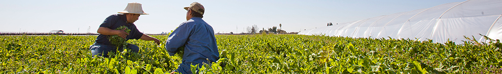
Researchers create app to help drones improve farm efficiency

When flown at the right times, drones can help farmers adapt to a changing climate
Researchers at the University of California, Davis, have developed a web application to help farmers and industry workers use drones and other uncrewed aerial vehicles, or UAVs, to generate the best possible data. By helping farmers use resources more efficiently, this advancement could help them adapt to a world with a changing climate that needs to feed billions.
Associate Professor Alireza Pourreza, director of the UC Davis Digital Agriculture Lab and postdoctoral researcher Hamid Jafarbiglu, who recently completed his doctorate in biological systems engineering under Pourreza, designed the When2Fly app to make drones more proficient and accurate. Specifically, the platform helps drone users avoid glare-like areas called hotspots that can ruin collected data.

Drone users select the date they plan to fly, the type of camera they are using and their location either by selecting a point on a map or by entering coordinates. The app then indicates the best times of that specific day to collect crop data from a drone.
Jafarbiglu and Pourreza, who is also a UC Cooperative Extension specialist of agricultural mechanization, said that using this app for drone imaging and data collection is crucial to improve farming efficiency and mitigate agriculture's carbon footprint. Receiving the best data — like what section of an orchard might need more nitrogen or less water, or what trees are being affected by disease — allows producers to allocate resources more efficiently and effectively.
"In conventional crop management, we manage the entire field uniformly assuming every single plant will produce a uniform amount of yield, and they require a uniform amount of input, which is not an accurate assumption," said Pourreza. "We need to have an insight into our crops' spatial variability to be able to identify and address issues timely and precisely, and drones are these amazing tools that are accessible to growers, but they need to know how to use them properly."
Dispelling the solar noon belief
In 2019, Jafarbiglu was working to extract data from aerial images of walnut and almond orchards and other specialty crops when he realized something was wrong with the data.
"No matter how accurately we calibrated all the data, we were still not getting good results," said Jafarbiglu. "I took this to Alireza, and I said, 'I feel there's something extra in the data that we are not aware of and that we're not compensating for.' I decided to check it all."
Jafarbiglu pored through the 100 terabytes of images collected over three years. He noticed that after the images had been calibrated, there were glaring bright white spots where they were supposed to look flat and uniform.
But it couldn't be a glare because the sun was behind the drone taking the image. So Jafarbiglu reviewed literature going back to the 1980s in search of other examples of this phenomenon. Not only did he find mentions of it, but also that researchers had coined a term for it: hotspot.

A hotspot happens when the sun and UAV are lined up in such a way that the drone is between the viewable area of the camera's lens system and the sun. The drone takes photos of the Earth, and the resulting images have a gradual increase in brightness toward a certain area. That bright point is the hotspot.
The hotspots are a problem, Jafarbiglu said, because when collecting UAV data in agriculture, where a high level of overlap is required, observed differences in the calibrated images need to come solely from plant differences.
For example, every plant may appear in 20 or more images, each from varying view angles. In some images, the plant might be close to the hotspot, while in others it may be situated further away, so the reflectance may vary based on the plant's distance from the hotspot and spatial location in the frame, not based on any of the plant's inherent properties. If all these images are combined into a mosaic and data are extracted, the reliability of the data would be compromised, rendering it useless.
Pourreza and Jafarbiglu found that the hotspots consistently occurred when drones were taking images at solar noon in mid-summer, which many believe is the best time to fly drones. It's an obvious assumption: the sun is at its highest point above the Earth, variations in illumination are minimal, if not steady and fewer shadows are visible in the images. However, sometimes that works against the drone because the sun's geometrical relationship to the Earth varies based on location and the time of year, increasing the chance of having a hotspot inside the image frame when the sun is higher in the sky.

"In high-latitude regions such as Canada, you don't have any problem; you can fly anytime. But then in low-latitude regions such as California, you will have a little bit of a problem because of the sun angle," Pourreza said. "Then as you get closer to the equator, the problem gets bigger and bigger. For example, the best time of flight in Northern California and Southern California will be different. Then you go to summer in Guatemala, and basically, from 10:30 a.m. to almost 2 p.m. you shouldn't fly, depending on the field-oriented control of the camera. It's exactly the opposite of the conventional belief, that everywhere we should fly at solar noon."
Grow technology, nourish the planet
Drones are not the only tools that can make use of this discovery, which was funded by the AI Institute for Next Generation Food Systems. Troy Magney, an assistant professor of plant sciences at UC Davis, mainly uses towers to scan fields and collect plant reflectance data from various viewing angles. He contacted Jafarbiglu after reading his research, published in February in the ISPRS Journal of Photogrammetry and Remote Sensing, because he was seeing a similar issue in the remote sensing of plants and noted that it's often ignored by end users.
"The work that Hamid and Ali have done will be beneficial to a wide range of researchers, both at the tower and the drone scale, and help them to interpret what they are actually seeing, whether it's a change in vegetation or a change in just the angular impact of the signal," he said.
For Pourreza, the When2Fly app represents a major step forward in deploying technology to solve challenges in agriculture, including the ultimate conundrum: feeding a growing population with limited resources.
"California is much more advanced than other states and other countries with technology, but still our agriculture in the Central Valley uses technologies from 30 to 40 years ago," said Pourreza. "My research is focused on sensing, but there are other areas like 5G connectivity and cloud computing to automate the data collection and analytics process and make it real-time. All this data can help growers make informed decisions that can lead to an efficient food production system. When2Fly is an important element of that."
This article was originally published on the UC Davis College of Engineering News page.
UCCE seeks statewide input to develop future wildfire programs

University of California Cooperative Extension has recently expanded their team of fire advisors and staff. This new group of UCCE fire professionals is interested in learning about the concerns of the communities that UCCE serves, as well as the natural resource professionals already working to address these issues.
Results from this survey will enhance the team's ability to partner with residents, landowners, agencies, academics, and other organizations to reduce California's vulnerability to wildfires. These new advisors will also share survey results with UCCE colleagues throughout the state, who already provide important fire-related programming across diverse landscapes and audiences.
"Wildfires will continue to affect all Californians, either directly or indirectly," said Katie Low, UCCE statewide fire coordinator. "It's invaluable to have the input of as many people as possible to guide the development of our wildfire-related extension programs, so that they can provide the most useful resources and information to communities across California."
The survey asks questions about topics such as:
- Gaps within existing educational programming and resources
- Challenges community members are facing in addressing wildfire risk
- Empowerment of communities to make property management decisions and prepare for wildfire
- Acceptability of prescribed fire and other fuels treatments
By participating in this study, you can choose to enter a drawing to win one of fifty $20 VISA gift cards.
To take the online survey, please visit https://bit.ly/UCCE_Fire_Survey.
This research is being led by a team of new UCCE fire advisors and staff. If you have any questions about this survey, please contact the fire/forestry professionals involved in this survey effort:
- Luca Carmignani, UCCE fire advisor for Los Angeles, Orange, Riverside, and San Diego counties, carmignani@ucanr.edu
- Alison Deak, UCCE fire advisor for Fresno, Madera, and Mariposa counties, aldeak@ucanr.edu
- Katie Low, UCCE fire academic coordinator for Nevada and Placer counties, katlow@ucanr.edu
- Barb Satink Wolfson, UCCE fire advisor for Monterey, San Benito, Santa Clara, and Santa Cruz counties, bsatinkwolfson@ucanr.edu
- Ryan Tompkins, UCCE forestry advisor for Plumas, Sierra, and Lassen counties, retompkins@ucanr.edu
For more information about wildfire-related programming from University of California Cooperative Extension, please visit https://ucanr.edu/sites/fire/ or the Facebook page https://bit.ly/fireSolutions.
Just what is a ‘resilient’ forest, anyway?

Study finds resilient, frequent-fire forests have far fewer trees
What does a “resilient” forest look like in California's Sierra Nevada? A lot fewer trees than we're used to, according to a study of frequent-fire forests from the University of California, Davis.
More than a century ago, Sierra Nevada forests faced almost no competition from neighboring trees for resources. The tree densities of the late 1800s would astonish most Californians today. Because of fire suppression, trees in current forests live alongside six to seven times as many trees as their ancestors did — competing for less water amid drier and hotter conditions.
The study, published in the journal Forest Ecology and Management, suggests that low-density stands that largely eliminate tree competition are key to creating forests resilient to the multiple stressors of severe wildfire, drought, bark beetles and climate change.
This approach would be a significant departure from current management strategies, which use competition among trees to direct forest development.
Defining ‘resilience'
But first, the study asks: Just what does “resilience” even mean? Increasingly appearing in management plans, the term has been vague and difficult to quantify. The authors developed this working definition: “Resilience is a measure of the forest's adaptability to a range of stresses and reflects the functional integrity of the ecosystem.”
They also found that a common forestry tool — the Stand Density Index, or SDI — is effective for assessing a forest's resilience.
“Resilient forests respond to a range of stressors, not just one,” said lead author Malcolm North, an affiliate professor of forest ecology with the UC Davis Department of Plant Sciences and a research ecologist with the U.S. Forest Service, Pacific Southwest Research Station. “‘Resistance' is about surviving a particular stress, like fire — but there's a lot more going on in these forests, particularly with the strain of climate change.”
Competitive nature
For fire-adapted forests in the Sierra, managing for resilience requires drastically reducing densities — as much as 80% of trees, in some cases.
“Treatments for restoring resilience in today's forests will need to be much more intensive then the current focus on fuels reduction,” said Scott Stephens of UC Berkeley, a co-author on the paper.
The study compared large-scale historical and contemporary datasets and forest conditions in the southern and central Sierra Nevada, from Sequoia National Forest to the Stanislaus National Forest. It found that between 1911 and 2011, tree densities increased six- to seven-fold while average tree size was reduced by half.
A century ago, both stand densities and competition were low. More than three-quarters of forest stands had low or no competition to slow a tree's growth and reduce its vigor. In contrast, nearly all — 82%-95% — of modern frequent-fire forests are considered in “full competition.”
The study indicates that forests with very low tree densities can be more resilient to compounded threats of fire, drought and other climate stressors while maintaining healthy water quality, wildlife habitat and other natural benefits. Forests burned by high-severity fires or killed by drought lose such ecosystem services.
Wake-up call
The authors say the 2012-2016 drought, in which nearly 150 million trees died from drought-induced bark beetle infestations, served as a wake-up call to the forestry community that different approaches are required to help forests confront multiple threats, not only severe wildfires.
A shift away from managing for competitive forests and toward eliminating competition could allow the few to thrive and be more resilient.
“People have grown accustomed to the high-density forest we live in,” North said. “Most people would be surprised to see what these forests once looked like when frequent surface fires kept them at very low densities. But taking out smaller trees and leaving trees able to get through fire and drought leaves a pretty impressive forest. It does mean creating very open conditions with little inter-tree competition. But there's a lot of historical data that supports this.”
“We think resilient forests can be created, but it requires drastically reducing tree density until there's little to no competition,” said Brandon Collins of UC Berkeley, another co-author on the paper. “Doing this will allow these forests to adapt to future climate.”
Additional co-authors include Ryan Tompkins of UC Cooperative Extension, and Alexis Bernal and Robert York of UC Berkeley.
The study was funded by the National Park Service Pacific West Region, U.S. Forest Service Pacific Southwest Research Station, U.S. Joint Fire Sciences Program, and the UC Agriculture and Natural Resources Division.
