By Laura Lukes, UC Master Gardener of Butte County, December 14, 2018

The chemistry of soil hydrophobia is fairly basic. Plant materials that burn hot release a waxy substance that penetrates the soil while still in gas form. It takes very high temperatures to produce this gas which coats soil particles when it cools and becomes solid. To the naked eye, hydrophobic soils look like their non-hydrophobic counterparts. But biologically speaking, they have now become latent disaster zones.

Runoff caused by rainfall on water-shedding soils can also cause the loss of fertile topsoil. And it can clog water conveyance facilities including manmade culverts, gutters, and ditches, as well as streams and rivers. The upside of rainfall on soil hydrophobicity is that, generally speaking, water repellency weakens with each rain event.
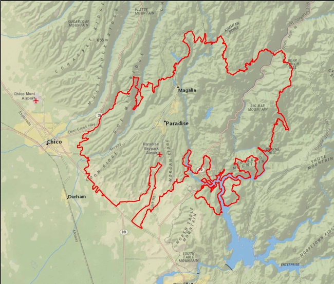
The type of soil and the intensity of the fire determine how deeply hydrophobia penetrates the soil, and how long the condition persists. Paradoxically, the fastest draining soils, (light, sandy soils with large pores) are the most prone to post fire hydrophobicity because they transmit the heat more easily than heavy, dense, clay soils. Soil types within the approximately 240 square miles burned by the Camp Fire vary from the sandy loam found in parts of Butte Creek Canyon to the red, rocky soils of the ridge communities. In general, the bulk of the burned area is perched atop the Tuscan formation. In its Soil Survey of Butte Area, California, Parts of Butte and Plumas Counties, the Natural Resources Conservation Service (NRCS) notes that these ridges “consist mainly of mudflow breccia, volcanic sandstone, and volcanic conglomerate.” The soils sitting on these thick layers of volcanic bedrock tend to be naturally clayey and slow draining.

Prescriptions for large scale mitigation within the burnt forested public lands, and the large acreages of undeveloped private landholdings, are outside of the scope of this article. For the private landowner, the following steps outlined by Douglas Kent in his Press Democrat article can be taken to lessen and control the damage caused by the treacherous combination of heavy rain and burn-scarred soils. These procedures can be followed if the homeowner is 1) allowed back onto his / her property and 2) able to stay long enough to put these measures in place.
To hold your ground:
- Clear drainage systems such as culverts, diversion ditches, or narrow swales, of debris. Clogged drains are a primary cause of erosion, even without fire damage.
- Divert water from areas originally designed to sheet runoff to the landscape: instead, redirect the runoff towards your newly cleared drainage systems or, if they exist, towards storm drain systems such as gutters. Use sandbags, diversion ditches, boards stacked on top of one another and staked in place, dry stacked walls, or bales to redirect water flow.
- Minimize foot and equipment traffic on burned landscapes. Such traffic can further compact already damaged soils on flat areas, and can weaken soil bonds and dislodge soil particles on slopes. Develop plans to restore your injured landscape before tramping on it, and keep all traffic to the bare minimum during restoration activities.
- Leave non-toxic debris in place wherever possible. Burnt plant remnants and other garden features can protect the landscape from wind and water erosion, and help protect any seeds and plants that survived the fire.
You may not want (or be able) to return to your property within the perimeter of the Camp Fire. On behalf of the Butte County Master Gardener Program, we hope this information will help you in the process of healing the scars on your land and those in your soul. If you don't, we hope you find peace and beauty wherever you choose to land and to landscape.
For more information on dealing with the effects of wildfire on soil, and landscaping with the possibility of fire in mind, see the Fire-Safe Landscape section of the UC Master Gardeners of Butte County website. Among other resources, see “The New Normal: Rebuilding Soil After Fire,” a PowerPoint presentation from the UC Master Gardeners of Sonoma County which covers how wildfires affect soil, soil regeneration, and strategies for dealing with toxic soil.
Photo Credits:
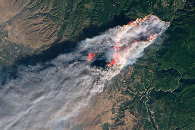
Camp Fire Burns on the Ridge
Source: NASA/MSFC, USGS
Area Affected by Camp Fire, Aerial View
Source: Esri, DigitalGlobe, GeoEye, Earthstar Geographics, CNES/Airbus DS, USDA, USGS, AEX, Getmapping, Aerogrid, IGN, IGP, swisstopo, and the GIS User Community
Area Affected by Camp Fire, Relief View
Sources: National Geographic, Esri, DeLorme, HERE, UNEP-WCMC, USGS, NASA, ESA, METI, NRCAN, GEBCO, NOAA, increment P Corp.