
Posts Tagged: IGIS
ESRI User Conference 2004 in San Diego - Day 3: Embracing AI
The third day of the ESRI User Conference was an exhilarating deep dive into the world of Artificial Intelligence. The AI Summit, the first of its kind hosted by ESRI, focused on the integration of AI into the ESRI ArcGIS Suite of software and tools. The excitement in the air was palpable as attendees explored the transformative potential of AI in GIS.
AI Summit Highlights
The AI Summit highlighted the strategic incorporation of AI into two broad categories within the ArcGIS ecosystem: GeoAI and AI Assistants.
- GeoAI: This category encompasses advanced AI models and algorithms specifically designed forgeospatial analysis. Attendees learned about howGeoAI can enhance spatial data interpretation, improve predictive modeling, and support more accurate decision-making. The sessions showcased real-world applications, demonstrating howGeoAI is being used to tackle complex challenges. These tools included:
- Deep Learning Models and object detection and pixel classification
- Unstructured text searching and geocoding
- and many others
- AI Assistants: These tools are designed to augment the user experience within theArcGIS platform, making it more intuitive and efficient. AI Assistants leverage generative AI to provide intelligent recommendations, automate routine tasks, and enhance data visualization. The demonstrations highlighted how these assistants can streamlineworkflows, improve productivity, and empower users to extract deeper insights from their data. AI assistants are being included in:
- Help documentation, online and within ArcGIS Pro
- Webmapping - Smart mapping
- Survey 123 webform design
- ArcGIS AI Hub Assistant
- and the list goes on
Innovative Applications and Future Directions
Throughout the day, experts and innovators shared their experiences and insights on the cutting-edge applications of AI in GIS. From machine learning models that classify historic and current aerial photos to AI-driven tools that optimize road condition extraction from full motion video capture, the presentations underscored the vast potential of AI to revolutionize the field.
Exciting Outcomes
One significant outcome of the day was my decision to request access to ArcGIS Hub Premium and its AI Assistant. This powerful tool will enable the querying of geospatial data created and maintained by IGIS and UCANR using AI using a natural language model. This will open up major opportunities for those needing information about UCANR and data that is important to Californians, making it easier to access, analyze, and leverage critical geospatial information.
Looking Ahead
The integration of AI into the ArcGIS Suite represents a significant leap forward, promising to unlock new possibilities for geospatial analysis and decision-making. As the conference progresses, attendees are eager to see how these advancements will continue to evolve and shape the future of GIS.
Perspective on AI
In response to concerns that AI might replace GIS professionals, the panelists provided some important perspectives. They emphasized that GIS professionals may potentially lose their jobs if they don't embrace AI. Just like if a GIS Professional was still using AML or Avenue programming laguages instead of modern languages and tools, they would eventually be replaced by someone who was using new languages and tools. The was reinforced a comment by one panelist who added, "If you lose your job because of AI, it will be to someone who is using AI."
Stay tuned for more updates and insights from the 2024 ESRI User Conference! The journey into the future of GIS, powered by AI, has just begun.
ESRI User Conference 2004 in San Diego - Day 1
The first day of the 2024 ESRI User Conference was filled with exciting announcements and innovative stories of Conservation and GIS. With around 21,000 attendees in San Diego and an additional people joining virtually, the energy and enthusiasm were palpable.
Plenary
Jack Dangermond and the ESRI team highlighted several new offerings in their plenary session. Notably, they introduced new datasets in the ArcGIS Living Atlas, including a national tile service of parcel boundaries and a feature layer of iNaturalist species observation data. These additions promise to provide users with even more comprehensive and valuable data for their projects.
The Governor of Minnesota, Tim Walz, a former high school Geography teacher, delivered an impassioned plenary speech on the importance of GIS in solving the challenges we face today. He emphasized the critical need for maps, data, and the work that GIS professionals do to address global issues.
New Apps and Features
ESRI also showcased a range of new apps in ArcGIS Online:
- Portfolio App: Designed to help users highlight key maps of interest, making it easier to share important insights with others.
- Web Editor App: This app offers a web-based editing experience similar to editing in ArcGIS Pro, making it more accessible for users to update and manage their data.
- Generative AI in AI Assistants: The inclusion of generative AI enhances the capabilities of spatial analysis, providing users with more intelligent and responsive tools and apps.
Additionally, several new story map templates were introduced, adding more options for users to create compelling narratives with their data.
Looking Ahead
With so many exciting developments on the first day, attendees can look forward to even more innovations and detailed sessions over the next three days. The future of GIS is looking bright, and the tools and features unveiled at this conference are set to drive the industry forward.
Stay tuned for more updates and insights from the 2024 ESRI User Conference in the coming days!
Lawn-pocalypse! Surviving Drought
Ah, summer! The season of sunburns, pool parties, and… lawn droughts. If your once lush, green carpet now looks like a crunchy brown doormat, you're not alone. Let's dive into why your yard is staging a dramatic death scene and what you can do to...

Bermuda grass and weeds overtaking drought stressed turf grass.
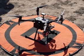
Learn how to use drones to collect field data June 24-28

DroneCamp in Monterey County offers lessons in person and online
Want to learn how to use drones to map and collect field data? DroneCamp 2024 will be held at California State University, Monterey Bay in Marina on June 24-28. For people who cannot attend in person, there is also an online option available.
No experience is necessary. Training will accommodate beginners as well as intermediate users who want to learn more advanced flight, data processing and analysis skills.
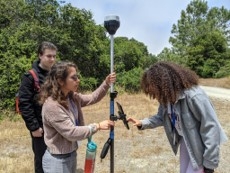
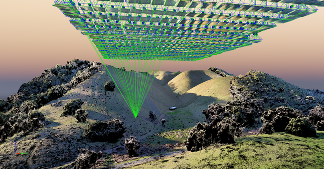
Now in its 8th year, DroneCamp is a five-day short course covering everything you need to know to get started using drones for mapping and research. The curriculum covers equipment, safety and regulations, flight planning, manual and autonomous flight, photogrammetry, data processing, data analysis, data management and research talks.
New for 2024 is a concurrent track for educators. Within these breakout sessions, instructors will present topics and methods for teachers developing drone programs, and will discuss drone technology, safety culture and remote-pilot code of conduct.
DroneCamp is led by a team of 21 instructors from UCMerced, UC Santa Cruz, CSU Monterey Bay, UC Davis, UC Berkeley, UC Santa Barbara, Lakeland College, American River College and UC Agriculture and Natural Resources.

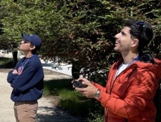
Participants attending the presentations in person will get hands-on experience in flight workshops, where they will have the opportunity to:
- Fly a variety of drone platforms
- Directly engage with instructors and other participants
- Expand their networks
- Gain access to all the software used throughout the week
- Explore the iconic Monterey Bay Area
Light refreshments, daily lunches and a Monday evening dinner social are included with in-person registrations. Participants must make their own lodging arrangements as housing is not available through campus.
Registration for in-person classes will close on June 5 or when capacity is reached. The registration fee is $1,200 for in-person participants, $700 for academics and students, and $120 for virtual participants. To register, visit https://bit.ly/DroneCamp2024.
For more information, see the agenda at https://dronecampca.org/2024-agenda, watch video highlights from 2023 or contact info@dronecampca.org.
DroneCamp is back!

June 24-28, 2024
CSU Monterey Bay
(plus virtual open)
DroneCamp is a premiere five-day training program that covers everything you need to know to use drones for mapping and data collection.
Curriculum at a Glance
- equipment
- safety & regulations
- flight planning
- manual & autonomous flight
- photogrammetry
- hands-on data processing with Pix4D, OpenDroneMap & ArcGIS Pro
- data analysis & visualization
- research talks & use cases
- educator track - new for 2024!
Now in its eighth year, Drone Camp 2024 will once again provide a unique drone training opportunity designed for a wide range of skill levels and interests, from complete beginners with little to no experience in drone technology, to intermediate users who want to learn more advanced data processing and analysis.
DroneCamp started out as an IGIS workshop, but has evolved into a highly collaborative program with instructors coming from 8 campuses including UC ANR, UC Merced, UC Santa Cruz, CSU Monterey Bay, UC Davis, UC Berkeley, UC Santa Barbara, Lakeland College, and American River College.
DroneCamp 2024 will be held in-person at CSU Monterey Bay June 24-28, 2024. Scholarships to cover the registration fee are available for all ANR academics and staff - but you must apply soon! More info available at DroneCampCA.org.
 |
 |
 |
 |
