San Joaquin Valley residents face pollution hazards
While California's San Joaquin Valley is home to some of the nation's richest agricultural resources, half of the people who live and work there face elevated levels of air and water pollution coupled with poverty, limited education, language barriers, and racial and ethnic segregation, according to a three-year UC Davis study.
The study, "Land of Risk/Land of Opportunity," also found that residents of the region report more environmental hazards than are currently documented or addressed by state agencies.
"Our conclusion is that immediate and comprehensive action is needed by local, regional and state policymakers to protect the health and well-being of the region's most vulnerable residents," said study leader Jonathan London, director of the UC Davis Center for Regional Change and an assistant professor of human and community development.
The study was conducted in partnership with the San Joaquin Valley Cumulative Health Impact Project, a community-university partnership with environmental health and social justice organizations in the San Joaquin Valley. This work is consistent with UC Davis' goals of seeking knowledge and solutions that sustain and improve quality of life for people in neighboring regions and around the world.
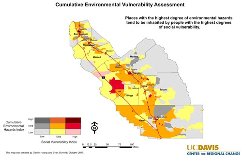
The study uses a new measure developed by scholars on this project, but drawn from methods used by other researchers -- the Cumulative Environmental Vulnerability Assessment -- to identify the locations and populations within the San Joaquin Valley that are at greatest risk.
According to that measure, 51 percent of San Joaquin Valley residents experience high cumulative environmental vulnerability, with more than half of those experiencing acute cumulative vulnerability.
Home to 4 million people, the San Joaquin Valley spans 300 miles through the center of the state. The region is a major transportation artery connecting northern and southern California and contains three of what the U.S. Department of Agriculture designates the nation's top-producing agricultural counties -- Fresno, Kern and Tulare.
The report found:
* The cumulative dangers were not evenly distributed across the region. Some of the communities facing the greatest levels of acute vulnerability include west Fresno, Monterey Park, Kettleman City, Matheny Tract, Earlimart and Wasco.
* Environmental and social vulnerability among at-risk populations persist, despite special attention from regulators and policymakers.
* Those with limited education and English fluency face difficulties advocating on their own behalf.
"With this report, we finally have the data that can lead to collaboration and action," said Kevin Hamilton, deputy chief of programs at Clinica Sierra Vista and a member of the San Joaquin Valley Cumulative Health Impact Project. "It's obvious to all that there are health and other disparities, but there's been a lack of data available to help communities, businesses and government collaborate to take next steps."
The report recommends that analysis of cumulative effects uncovered in the study be integrated into existing policy and planning frameworks in the region, and that special attention be focused on higher-risk areas.
"With one in two residents at elevated risk and one in three at extreme risk, now is the time to solve big problems by looking at the big picture. Without broad discussion and creative solutions, the San Joaquin Valley, especially its children, can't reach its full potential," said Sarah Sharpe, of Fresno Metro Ministry, who coordinates the San Joaquin Valley Cumulative Health Impacts Project.
"This report provides policymakers, government agency leaders, and community activists a tool to measure the cumulative impacts on Valley residents and a road map to prioritizing solutions to these problems."
The study was supported by funding from the Ford Foundation, the UC Davis John Muir Institute of the Environment, the William and Flora Hewlett Foundation, and the Community Forestry and Environmental Resource Partnerships graduate fellowship.
The report is available at http://regionalchange.ucdavis.edu/projects/current/ceva-sjv.
###
Media contacts:
Edit Ruano, Full Court Press Communications, (510) 550-8176, edit@fcpcommunications.com
Karen Nikos, UC Davis News Service, (530) 752-6101, kmnikos@ucdavis.edu

