

By:

Dr. Zaw Wai Htoo, Community Nutrition and Health Program
University of California Cooperative Extension – San Francisco North Bay
Posted: July 30, 2026
Wildfire smoke can affect communities many miles from an active fire. Even if you are not near the fire itself, smoke can travel long distances and reduce air quality, potentially affecting your health.
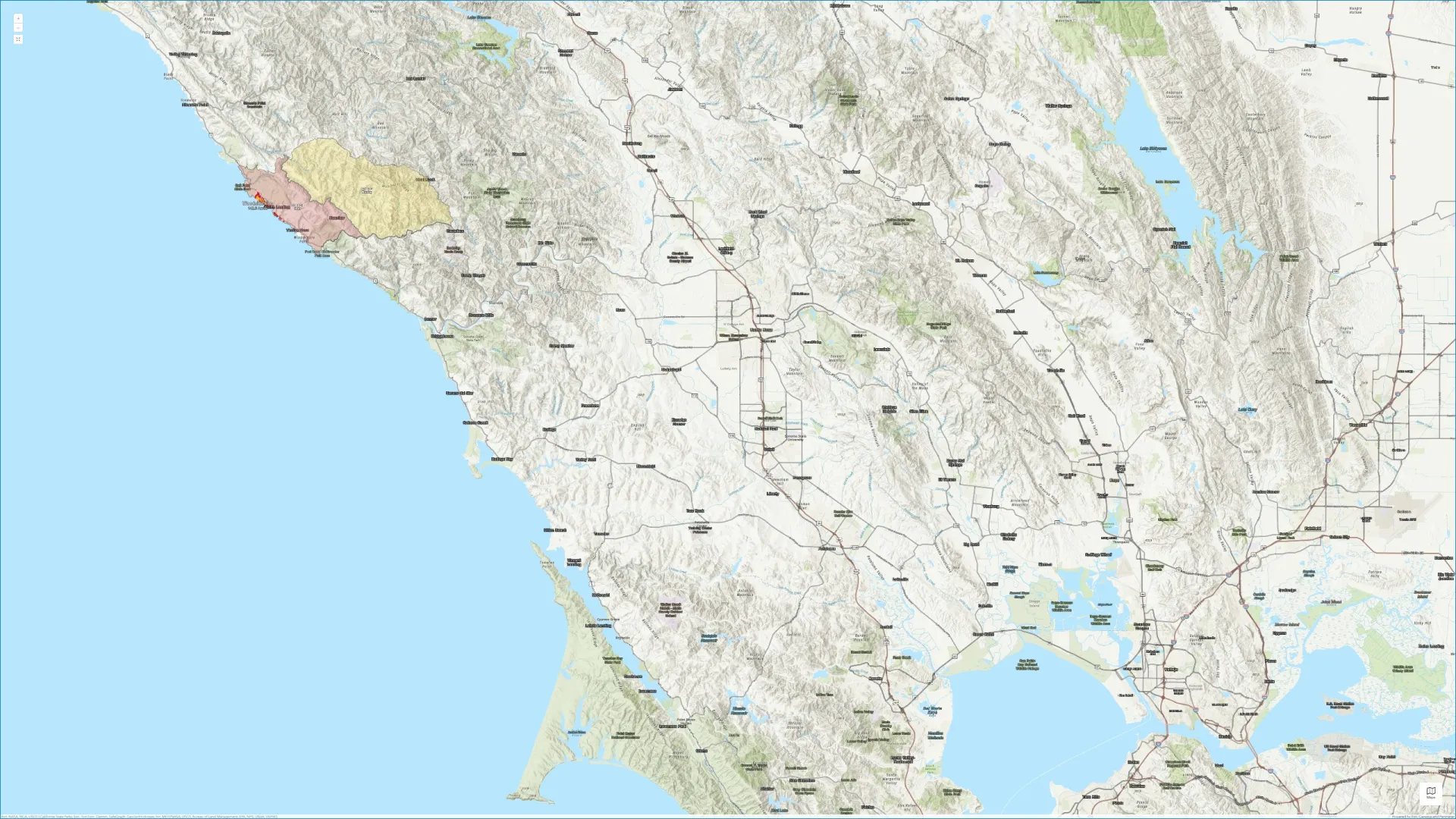
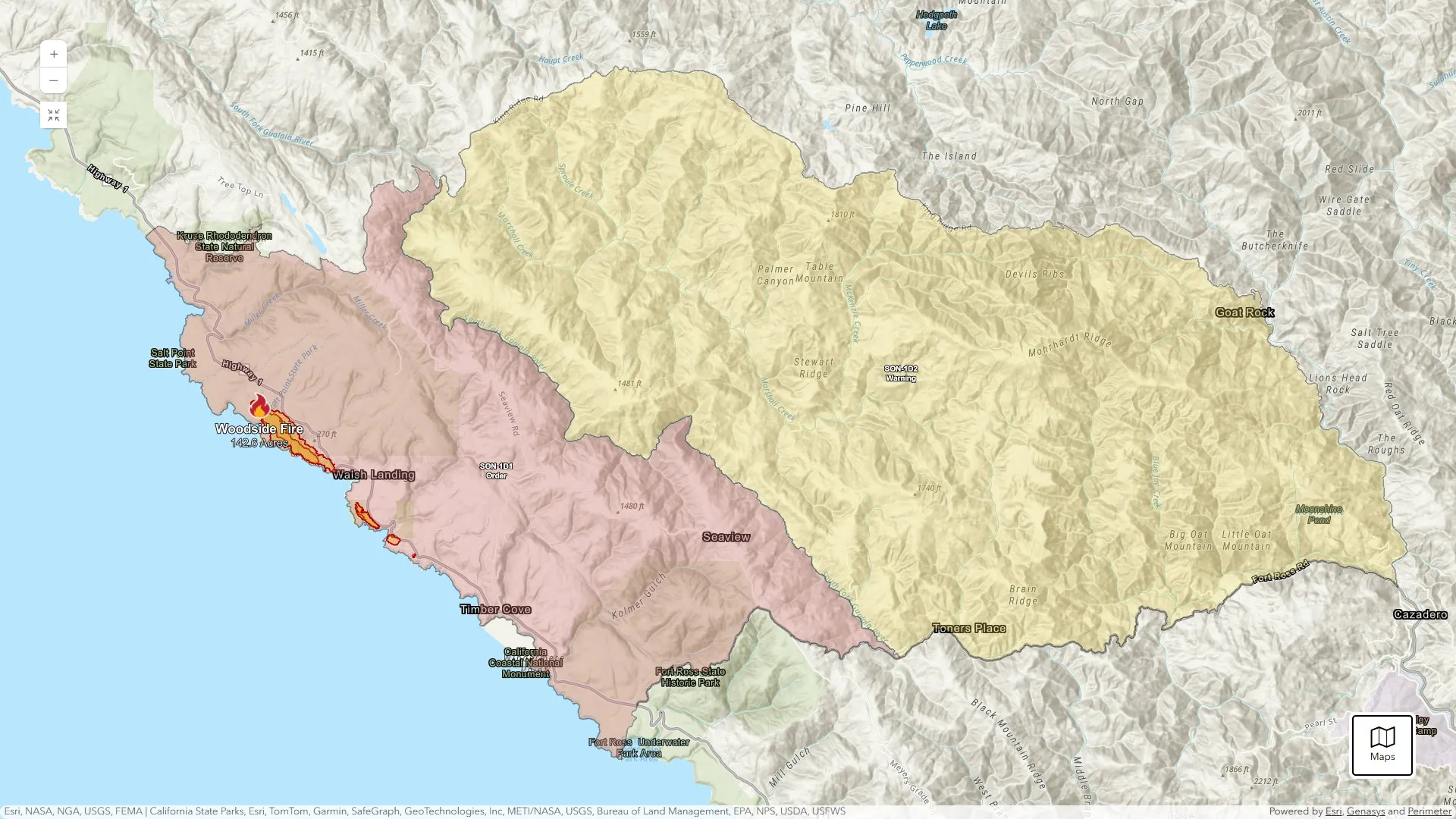
As the Woodside Fire continues in Sonoma County, smoke may affect air quality across parts of Sonoma County and neighboring communities, depending on weather conditions and wind patterns. Air quality can change rapidly throughout the day. We encourage everyone to stay informed and take practical steps to reduce smoke exposure.
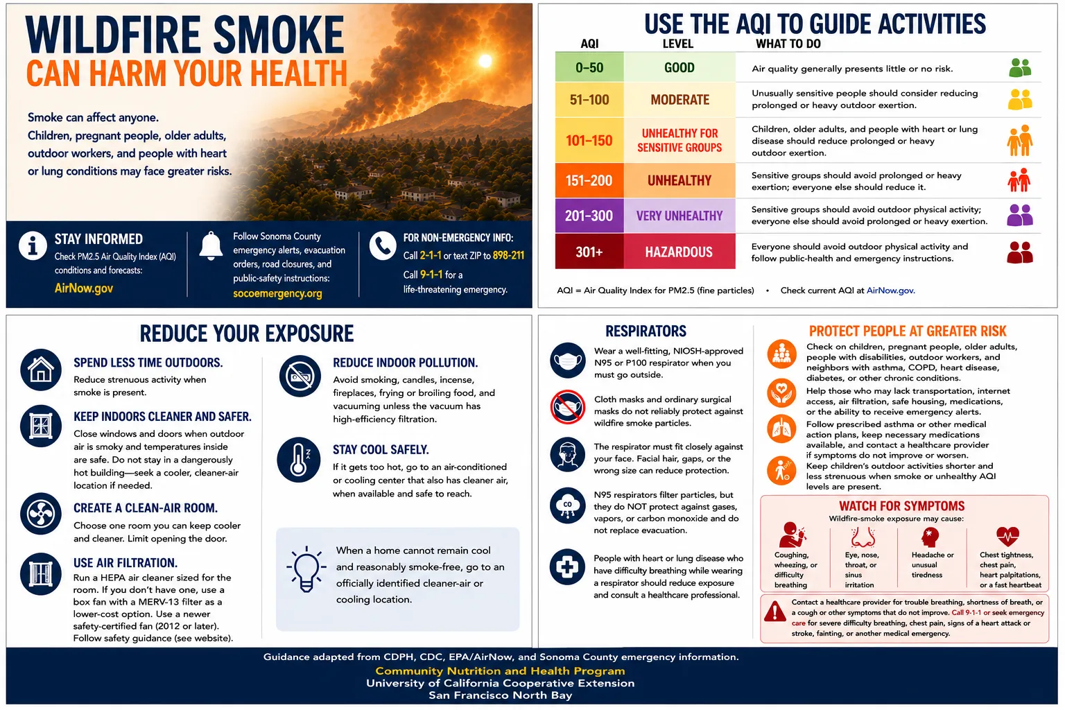
*Download the "Wildfire Smoke and Your Health" educational infographic and safety tips here: https://drive.google.com/file/d/15jn1_kGcsrYyFZkcs0gVii-y8k42JqLE/view?usp=sharing
Current Situation
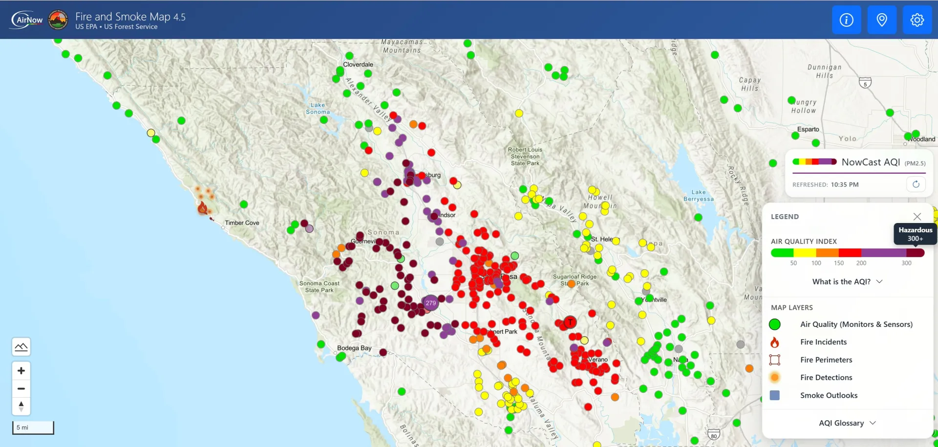
Understanding the Air Quality Index (AQI)
The Air Quality Index (AQI) is a tool developed by the U.S. Environmental Protection Agency to communicate how clean or polluted the air is and the potential health effects associated with current air quality conditions.
General guidance
- AQI 0–50 (Good)- Air quality poses little or no health risk.
- AQI 51–100 (Moderate)- Unusually sensitive individuals should consider reducing prolonged outdoor exertion.
- AQI 101–150 (Unhealthy for Sensitive Groups)- Children, older adults, pregnant individuals, and people with heart or lung disease should reduce prolonged outdoor activities.
- AQI 151–200 (Unhealthy)- Everyone should reduce prolonged or strenuous outdoor activities.
- AQI 201–300 (Very Unhealthy)- Avoid outdoor activities whenever possible and stay in cleaner indoor air.
- AQI 301 and above (Hazardous)- Avoid outdoor exposure, remain indoors if it is safe to do so, and follow guidance from public health and emergency officials.
Practical Steps to Reduce Smoke Exposure
You can help protect yourself and your family by taking the following actions-
- Check current AQI conditions before spending time outdoors.
- Reduce or postpone strenuous outdoor activities when smoke levels are elevated.
- Keep windows and doors closed when outdoor air is smoky and indoor temperatures remain safe.
- Create a cleaner indoor space by using a portable HEPA air cleaner if available.
- If you do not have a portable air cleaner, a properly constructed DIY box fan with a MERV-13 filter may help improve indoor air quality when used according to safety guidance.
- Avoid activities that create additional indoor air pollution, such as smoking, burning candles or incense, using fireplaces, or prolonged frying and broiling.
- If outdoor exposure cannot be avoided, wear a well-fitting NIOSH-approved N95 respirator.
- Stay hydrated and monitor yourself and family members for symptoms related to smoke exposure.
Protect Those at Greater Risk
Some individuals are more vulnerable to wildfire smoke and may experience health effects sooner than others.
These include-
- Older adults
- Infants and young children
- Pregnant individuals
- People with asthma, COPD, or other lung diseases
- Individuals with heart disease
- Outdoor workers
- People with disabilities or chronic medical conditions
- Individuals without access to cleaner indoor air or air filtration
Please consider checking on neighbors, family members, and friends who may need additional assistance during periods of poor air quality.
Know the Difference Between an Evacuation Warning and an Evacuation Order
During an active wildfire, emergency officials may issue evacuation notices (tap on this link to view).
- Evacuation Warning- Be prepared to leave quickly if conditions worsen. Gather medications, important documents, pets, and essential supplies.
- Evacuation Order- Leave immediately using designated evacuation routes. Do not delay to gather additional belongings.
Always follow instructions (tap on this link to view) from local emergency management officials.
Watch for Smoke-Related Symptoms
Wildfire smoke may cause-
- Coughing or wheezing
- Shortness of breath or difficulty breathing
- Eye, nose, or throat irritation
- Headache
- Fatigue
- Chest discomfort or chest pain
- Rapid or irregular heartbeat
Seek medical attention promptly if symptoms become severe or do not improve. Call 911 immediately for severe difficulty breathing, chest pain, signs of a heart attack or stroke, loss of consciousness, or another medical emergency.
Stay Informed
For the latest wildfire and air quality information, please visit:
- AirNow Fire and Smoke Map
- CAL FIRE Incident Information
- Sonoma County Emergency Information
- California Department of Public Health
- Centers for Disease Control and Prevention
The Community Nutrition and Health Program at the University of California Cooperative Extension, San Francisco North Bay, provides timely, evidence-informed educational resources that help individuals, families, and communities make informed decisions to protect their health during emergencies.
While wildfire smoke can pose significant health risks, practical actions such as monitoring air quality, reducing smoke exposure, creating cleaner indoor environments, and staying informed through trusted sources can help reduce those risks.
This educational resource is intended to support public health awareness and preparedness. It does not replace guidance from healthcare professionals, emergency management agencies, or local public health authorities. During an active wildfire, always follow official evacuation orders, emergency alerts, and public safety instructions.

You can view live camera footage here (Courtesy of UC San Diego, Alert California, PG&E) - Axis-MohrhardtRidge1&pos=37.2303_-119.0039_6 :