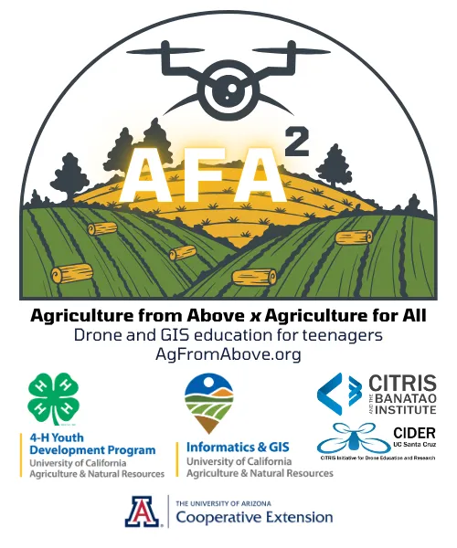
Ag from Above x Ag for All (AFA2) is aimed at sparking interest in food and agriculture among teenagers by using cutting-edge drone and mapping technologies. By blending hands-on activities with real-world applications, AFA2 empowers young people to explore the science behind agriculture in fun and meaningful ways. AFA2 is not just about teaching technology—it's about using that technology to make a real difference in communities and ensuring that the next generation of agricultural scientists and leaders is diverse, skilled, and ready to take on the challenges of the future.
Partners
University of California's Cooperative Extension, 4-H Youth Development Program, Informatics and GIS Program, the UC Santa Cruz CITRIS Initiative for Drone Education and Research, and the UC Davis AI Institute for Next Generation Food Systems.
- PI: Steven Worker, 4-H Youth Development Advisor (Sonoma)
- Co-PI: Nathaniel Caeton, 4-H Youth Development Advisor (Shasta)
- Co-PI: Matthew Rodriguez, 4-H Youth Development Advisor (Placer)
- Co-PI: Andy Lyons, IGIS Program Coordinator (UC Berkeley)
- Co-PI: Sean Hogan, IGIS Academic Coordinator (Davis)
- Collaborator: Flavie Audoin, Rangeland Management Extension Specialist (Univ. of Arizona)
- Collaborator: Lucy Diekmann, Urban Agriculture/Food System Advisor (Santa Clara)
- Collaborator: Becca Fenwick, Director, CITRIS Initiative for Drone Education and Research (UCSC)
Acknowledgements
This work is supported by the U.S. Department of Agriculture, National Institute of Food and Agriculture, Agriculture and Food Research Initiative Competitive Grants Program, award #2024-68018-42793. The findings and conclusions in this program have not been formally disseminated by the U. S. Department of Agriculture and should not be construed to represent any agency determination or policy.

We are developing, testing, and evaluating two curricula targeting teenagers aged 13 to 18 years old.
SkyMappers: Agricultural Drones and GIS Mastery (Curriculum)
A curriculum designed for youth ages 13 to 18 that introduces drones, remote sensing, and geographic information systems as tools for investigating agriculture, food systems, environmental conditions, and community issues. Youth progress from matching drone types and payloads to real-world missions, to learning responsible flight rules, equipment care, airspace awareness, crew communication, preflight routines, and supervised flight skills. They then explore how drone imagery becomes useful data through GPS, photo stitching, sensor imagery, spatial resolution, Esri Drone2Map and ArcGIS, and careful interpretation. The curriculum culminates in youth-driven projects in which teams define a mission question, plan a safe and respectful workflow, collect or use imagery, process data, interpret results, and present findings. The curriculum integrates experiential learning, project-based learning, positive youth development, culturally relevant pedagogy, and data ethics. Across the sequence, youth build five core competencies: place-based problem framing, responsible operations, mission design for data quality, imagery processing, and GIS-based analysis and communication. The curriculum emphasizes safety, FAA awareness, privacy, consent, cultural respect, and the importance of choosing whether drones are the right tool for a given purpose.
Lesson List (revision May 2026)
- Front Matter, Learning Goals, Pedagogy, and Materials
- Lesson 01: Build Your Fleet: Drone Types, Payloads, and Purpose (1 hour)
- Lesson 02: Drone Rules & Responsible Flight (1 ½ hours)
- Lesson 03: Get to Know Your Gear: Equipment & Inspection (Indoor) (1 hour)
- Lesson 04: Drone Startup, Calibration & Preflight Procedures (Outdoor) (1 hour)
- Lesson 05: Your Flight Path: Discovering Drone-Powered Jobs (1 hour)
- Lesson 06: Sky Rules: Reading Airspace Charts (45 minutes)
- Lesson 07: Team in Flight: Crew Resource Management (1 hour)
- Lesson 08: Nano-Mini Drone Skills Lab (1 hour)
- Lesson 09: Ready to Fly: Preflight Safety Circuit (1 hour)
- Lesson 10: Flight Check: TRUST Certification (30 to 60 minutes)
- Lesson 11: Clear Skies Ahead: Drone Flight Day (1 ½ hours)
- Lesson 12: Turning Flight into Insight: Intro to Drone Data Processing (1 ½ hours)
- Lesson 13: Processing the Data with Esri ArcGIS and Drone2Map (1 ½ hours)
- Lesson 14: Data Ethics & Culturally Responsive Mapping (1 hour)
- Lesson 15: Autonomy Begins on the Ground: Mission Planning & Safety (1 hour)
- Lesson 16: Conducting the Autonomous Flight (2 to 3 hours)
- Lesson 17: Youth-Driven Drone Missions (5 to 8 ½ hours)
Dronovation: Cultivating Change with Teens (Curriculum)
Dronovation: Cultivating Change with Teens is a field project guide for educators who are ready to help teen teams apply drone, remote sensing, and GIS learning to real-world questions in agriculture, food systems, environmental conditions, land stewardship, and community well-being. Designed as Curriculum #2 in the Ag from Above x Ag for All sequence, Dronovation extends SkyMappers: Agricultural Drones and GIS Mastery by moving youth from structured learning activities into authentic client-connected projects. Youth work in teams of three to clarify a client need, define a project question, assess whether drone imagery, GIS, field observation, or public data are the right tools, plan a safe and ethical workflow, gather or use data, interpret patterns, and produce client-ready products. The guide is organized as a 20-hour sequence across ten 2-hour meetings. It includes educator preparation guidance, project readiness tools, learning objectives, equipment planning, client engagement practices, and two adaptable learning pathways: a field or flight-based project sequence and a GIS-only project sequence. Across both pathways, youth practice the five SkyMappers Core Knowledge Elements: purpose and place-based problem framing, responsible operations, mission design for data quality, processing imagery into map-ready products, and GIS analysis, interpretation, and ethical communication. The sequence also carries forward the Core Pedagogical Elements from SkyMappers: experiential learning, project-based learning, positive youth development, and culturally relevant and locally relevant pedagogy.
- Part 1 - Field Project Guide
This Field Project Guide helps educators support teen teams as they complete a real-world drone and GIS project for an authentic client. Dronovation is a project-based learning experience in which youth use technical tools, teamwork, professional communication, local knowledge, and ethical judgment to produce something useful for someone beyond the learning group. - Part 2 - Clients and Projects Catalog
This catalog is a companion to the Field Project Guide. Use the Guide to run the 10-meeting sequence. Use this catalog to choose a real client and a right-sized project that fits your geographic area, calendar, sites, and teen teams. Start with the Selection Matrix to narrow options by complexity tier, field or desk work, season, and access. Then find the matching category to read a short client summary and pick a ready-to-run project idea with clear products.
Educator Guide
Part 1: Overview and Logistics
Part 1: Overview and Logistics introduces the purpose, structure, and implementation approach for the AFA2 Educator Toolkit. This part helps educators understand what the curriculum is designed to accomplish, what a quality implementation looks like, how the curriculum aligns with the Core Knowledge Elements and Core Pedagogical Elements, and what was learned from pilot implementation. Part 1 is intended for program leads, site coordinators, educators, partners, and administrators who need a clear overview before planning a 4-H club series, afterschool program, summer academy, community-based workshop, or youth workforce experience.
- A. Curriculum Summary and What a Quality Program Looks Like
- B. Alignment with the Core Knowledge Elements
- C. Alignment with the Core Pedagogical Elements
- D. Program Implementation Lessons Learned
Part 2: Educator Readiness
Part 2: Educator Readiness describes the knowledge, competencies, and preparation educators need before facilitating AFA2 lessons with youth. This part is not a complete flight manual, legal guide, or GIS textbook. Instead, it identifies the practical readiness areas educators should understand well enough to plan safe learning experiences, recognize when expert help is needed, and connect each activity to the larger drone-to-map workflow.
- A. FAA, Safety, and Legal Literacy
- B. Remote Pilot in Command
- C. Flight Operations
- D. Data and GIS: Photogrammetry Basics, Drone2Map Workflow, and Publishing to ArcGIS Online
- E. Facilitation with Diverse Teens
Part 3: Operational Readiness
Part 3: Operational Readiness helps educators and program leads prepare the equipment, software, facilities, approvals, insurance documentation, field procedures, and records needed to implement AFA2 safely and effectively. Parts 1 and 2 describe the curriculum framework and educator readiness. This part focuses on the operating conditions that should be in place before youth arrive.
- A. Equipment, Computers, and Software
- B. Hosting, Authorization, and Insurance
- C. Facilities, Airspace, and Site Permissions
- D. Records and Data Governance
- E. Educational Drone Program Checklist
Part 4: Educational Experiences
Part 4: Educational Experiences helps educators facilitate high-quality learning, reflection, evidence of learning, youth feedback, project assessment, and family showcases. Parts 1 through 3 describe the curriculum framework, educator readiness, and operational readiness. This part focuses on what happens during and after learning experiences: how educators ask questions, support youth voice, guide reflection, assess projects, collect feedback, and help youth communicate their work to families and community audiences.
- A. Instructional Quality and Reflection
- B. Evaluation and Evidence of Learning
- C. Youth Survey Instrument
- D. Youth Interview and Focus Group Protocols
- E. Lesson 17 Project Rubric: Youth-Driven Drone Missions
- F. Making the Lesson 17 Family Showcase Excellent
- G. Family Showcase Invite Letter
Part 5: Preparing the Educator
Part 5 is written for program coordinators, site leads, and others responsible for preparing educators to facilitate AFA2. Parts 1 through 4 explain the curriculum framework, educator readiness, operational readiness, and educational experiences. This part focuses on how coordinators can build educator competence before implementation and continue supporting educators during early delivery.
- A. Self-Paced Learning Resources
- B. Three-Day Hands-On Educator Workshop
- C. Ongoing Support and Coaching Menu
- D. Coordinator Checklist: Educator Readiness
- E. Minimum Preparation Pathway
Newsletter

Project Materials
PROMOTION
- Drone Camps to Help Teens’ Interest in Science Take Off in Morning AgClips, June 9, 2025
Youth Drone Academies
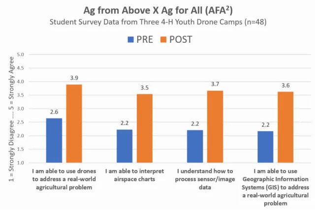
Summer 2025, 50 teenagers discussed, debated, and reflected on legal and ethical uses of drone imagery as one of fourteen lessons from the new 4-H curriculum, SkyMappers: Agricultural Drones and GIS Mastery. Teens learned to safely fly drones, capture aerial images, process data, and use GIS mapping software. Through hands-on activities and teamwork, they explore topics like crop health, livestock monitoring, and food justice, while developing STEM skills that prepare them for future careers in agriculture, technology, and environmental science.