Posts Tagged: Emily C. Dooley
Lawn-pocalypse! Surviving Drought
Ah, summer! The season of sunburns, pool parties, and… lawn droughts. If your once lush, green carpet now looks like a crunchy brown doormat, you're not alone. Let's dive into why your yard is staging a dramatic death scene and what you can do to...

Bermuda grass and weeds overtaking drought stressed turf grass.
Understanding cattle grazing personalities may foster sustainable rangelands
Matching herds to landscape can support animal growth and ecological needs
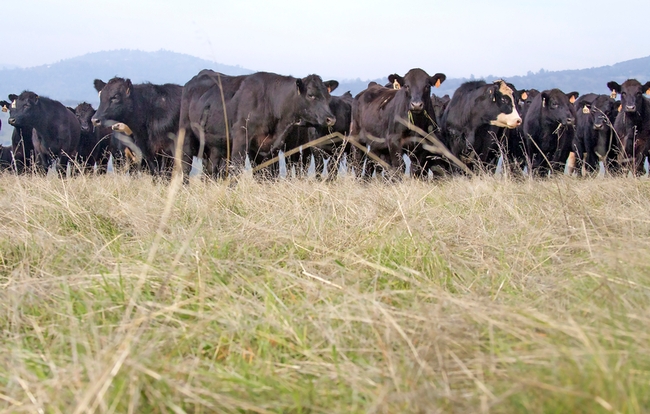
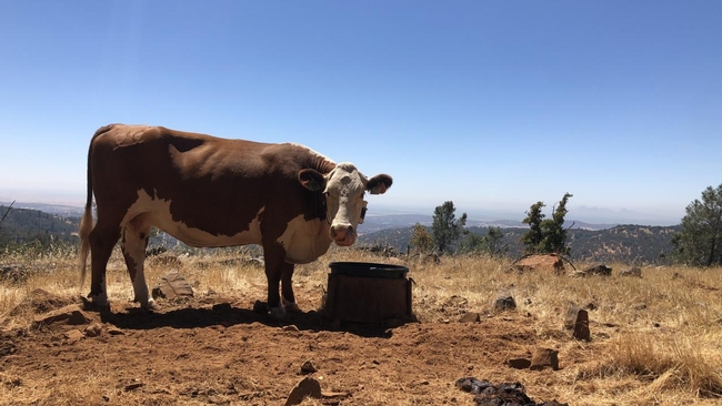
Not all cattle are the same when it comes to grazing. Some like to wander while others prefer to stay close to water and rest areas.
Recognizing those personality differences could help ranchers select herds that best meet grazing needs on rangelands, leading to better animal health and environmental conditions, according to a new paper from the University of California, Davis, published in the journal Applied Animal Behaviour Science.
“Cattle can actually be beneficial for the rangelands,” said lead author Maggie Creamer, who recently earned her Ph.D. in animal behavior at UC Davis. “Vegetation in rangelands actually need these kinds of disturbances like grazing.”
Ranchers can add elements to the rangeland such as water, mineral supplements and fencing to influence where cattle graze, but little research has been done on how those efforts affect individual cows. Considering personalities could save money.
“If you're spending all this money to add a management tool in order to change the distribution of your animals, that's a huge cost to ranchers,” said Creamer. “Thinking about other tools, or selecting certain animals with these grazing traits, might be a better way to optimize the distribution on rangeland rather than spending a bunch of money for something that may ultimately not pan out for all your animals.”
Effects of grazing
Livestock graze on an estimated 56 million acres in California, and healthy rangelands host native vegetation and animals, foster nutrient cycling and support carbon sequestration.
Uneven grazing can degrade water quality, soil health and habitats. Optimizing grazing — including the even spread of cow pies — can improve the ecosystem while also reducing fuel loads for wildfires.
To better understand individual grazing patterns, researchers went to the UC Sierra Foothill Research and Extension Center in Browns Valley and tracked 50 pregnant Angus and Hereford beef cows fitted with GPS collars.
The research
The cattle, which were tracked from June to August over two years, had access to 625 acres of grasslands and treed areas ranging in elevation from 600 to 2,028 feet. In the second year, a new watering site was added at a higher elevation.
Across the two years, the cows showed consistent and distinct grazing patterns even when water sources changed. Age and stage of pregnancy did not affect patterns, though cattle tended to clump near water and rest sites on hotter days.
The cows that ventured into higher elevations and farther from watering sites had more variability in their grazing patterns than those that stayed at lower elevations near water. That suggests it may be harder for non-wanderers to adjust to some landscapes.
“Thinking about the topography of your rangeland and your herd of cows can benefit both the animals and the sustainability of the land,” said Creamer, who next month begins work as a postdoctoral scholar in North Carolina.
Gauging personalities
Keying in on personality type may sound difficult, but the researchers also found some clues as to how to pinpoint the wanderers and homebodies. Unlike cattle at feedlots, the breeding cow population, especially on rangelands in California and other western states, live largely “wild” lives and are rarely handled, save for vaccinations and weaning.
Research due to be published later this year found that paying attention to individual cow reactions during those events can help determine personalities. The cows that appeared more passive during those handling interactions tended to be nomadic.
“We found that you can maybe predict those hill climbers if you kind of look at how they act when the veterinarian or rancher handle them,” said senior author Kristina Horback, an associate professor in the Department of Animal Science at UC Davis.
Informing practices
For ranchers, the findings could be invaluable, said Dan Macon, a livestock and natural resources Cooperative Extension advisor in Placer and Nevada counties for UC Agriculture and Natural Resources.
“Any time we can improve our understanding of cattle behavior, particularly at the individual level, it can improve how we handle livestock and manage the landscape,” he said.
Macon said that during the recent drought, it was hard to get cattle into higher country, but if ranchers could have selected the nomads, it may have saved money in terms of ranch labor and other efforts.
“If you ask a rancher who has been attentive to their cattle over many years, they know the personalities,” Macon said.
For Creamer and Horback, the research opens new doors into understanding herd behavior and dynamics, one that could be a cheaper alternative to high-tech solutions.
“Animal science tends to look overlook the mind of the animal when searching for solutions to challenges,” Horback said. “It's always been a direct line to genetics for immunity or nutrition, but nothing about the mind of the animal. And that's such a loss. There's so much we can learn from behavior in the end.”
The Russell L. Rustici Rangeland and Cattle Research Endowment supported the research.
This article was first published on the UC Davis News site.
Google Weed View? Professor trains computer to spot invasive weed
Algorithm for AI enables low-cost tracking of invasive plant
To manage johnsongrass, a noxious weed that crowds out cotton and sickens horses, farmers have tried herbicides, burning and hand-pulling. Now, researchers at University of California, Davis, have developed a more high-tech weapon against the invasive weed: artificial intelligence and machine learning.
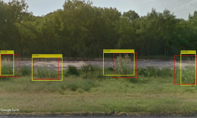
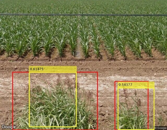
Using photos from Google's Street View database, UC Davis researchers have tracked down over 2,000 cases of johnsongrass in the Western United States for a fraction of the cost and time that it would take to do drive-by or other in-person surveys. They call their tool Google Weed View.
The advancement could help land managers easily and quickly survey for other problem plants.
“Once the model is trained, you can just go and run it on millions of images from Google Street View,” said Mohsen Mesgaran, an assistant professor in the Department of Plant Sciences at UC Davis. “We have huge flexibility, and its capability can be scaled up very quickly.”
The technique can easily be extended to other plant species. All that is needed is to label the new item in Street View photos and train the algorithm to identify that object in the images.
By providing location information, Google Weed View also offers an opportunity to examine how climate affects the growth and spread of weeds and invasive plants at very large scales.
“I think it can be both useful for management and for people with interests in more basic questions in ecology,” Mesgaran said.
A colleague's query
Mesgaran began looking at using Google's photo database of roadways, streets and highways after Kassim Al-Khatib, a professor of Cooperative Extension in the same department, asked if he could survey Western states for johnsongrass.
Al-Khatib studies where johnsongrass grows, ways to manage it and how this perennial has evolved to be so prevalent and resilient. He's also working with scientists at the University of Georgia to decode the genome of johnsongrass, which is one of the top 10 most invasive weeds worldwide.
Johnsongrass can crowd out native plants, harbor pathogens and affect agriculture. It grows up to 7 feet tall with flowers that are green, violet, dark red or purplish brown depending on maturity, according to a UC Statewide Integrated Pest Management Program briefing page.
“Johnsongrass is a major weed not just in California but worldwide,” Al-Khatib said. “It's very difficult to control. It's a problem on vineyards. It's a problem for cultivated crops. It's a problem on orchards.”
Google Weed View allows for rapid, convenient scanning. It is continuously updated via everyday users with compatible cameras and images collected by Google. “Instead of a day of in-person driving, we can use AI to determine if johnsongrass is in a county or not,” Al-Khatib said.
Setting the parameters
To find the weeds, Mesgaran went to Google Street View, which hosts billions of panoramic photos. It didn't take long to find johnsongrass.
“The pictures are really good quality,” he said. “You can see plants and flowers.”
Street View's photos offer a 360-degree view, so in his request Mesgaran set parameters, based on street direction (bearing), to only see the side view. He also specified latitude and longitude, and other factors. To train the deep, or machine learning model, he chose Texas, where johnsongrass is prevalent.
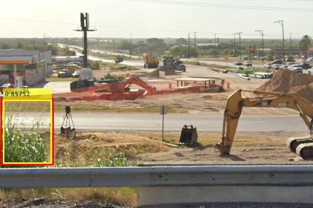
A student sorted through over 20,000 images from that request to find pictures with johnsongrass and drew rectangular shapes around the weeds. They located 1,000 images.
The labeled photos were fed into a computer to train a deep learning algorithm capable of identifying johnsongrass in Google's images. The model was run again to capture potentially more images containing johnsongrass. These additional images were then labeled and used to further refine the model. With each iteration, the algorithm learned and became more accurate.
“This deep learning model was trained by these images,” Mesgaran said. “Once we had a semi-working model, we ran it against about 300,000 images.”
For Al-Khatib's request, researchers focused on 84,000 miles of main roads in California, Nevada, Oregon and Washington states. The team discovered 2,000 locations with johnsongrass.
Google Weed View cost less than $2,000 to purchase the images and teach the model. A traditional car survey to cover the same area would cost an estimated $40,000 in gas, hotel, food and other costs.
“In a matter of months, we came up with 2,000 records and I can do it for the whole U.S.,” Mesgaran said.
Next up? The entire United States.
This story was originally published on the UC Davis College of Agricultural and Environmental Sciences news site.
Winter atmospheric rivers gave pathogens, diseases path to infect crops
Outbreaks similar to El Niño-influenced issues of the 1990s
The wave of atmospheric rivers that swept across the state this winter has created the right conditions for plant pathogens that haven't been seen for decades in California. University of California, Davis, plant pathologist Florent “Flo” Trouillas is getting more calls from growers and farm advisors concerned about potential crop damage.
“Generally, whenever you have rain events, you're going to have problems,” said Trouillas, a Cooperative Extension specialist who is based at the Kearney Agricultural Research and Extension Center in Parlier. “In wet years we get really busy because most pathogens need and like water.”
Trouillas is like a disease detective. He splits his time between the field and the lab, working to diagnose pathogens, diseases and other ailments that strike fruit and nut crops such as almonds, cherries, olives and pistachios.
On a recent visit to an almond orchard near Fresno, Trouillas joined Mae Culumber, a nut crops farm advisor for UC Cooperative Extension Fresno County. A few weeks earlier, the two had walked the orchard, taking note of the base of some trees that had gumming — a thick, jelly-looking substance indicating a pathogen had taken hold.
“A lot of what Florent is doing is trying to assess patterns on a landscape,” Culumber said. “Sometimes things may look like they are one thing, but it could be another problem.”
When the two returned weeks later, the amber-colored gumming had moved into the canopy, looking like gumballs stuck to branches, some of which were already dead. “It's getting out of control from before,” Trouillas says. “This branch was killed. This is widespread.”
From the field to the lab
Lab testing confirmed what Trouillas believed was the culprit: Phytophthora syringae, a pathogen that can affect almond crops but is rarely seen in California. If it is found, generally the site of infection are wounds caused by pruning, but that is not the case here, where the infection began in the canopy at twigs, or small branches.
It is a threat to a key crop, which according to the California Department of Food and Agriculture, generates $5 billion annually. The last time Phytophthora syringae hit California was in the 1990s after a series of El Niño-influenced storms. Trouillas, who has a photographic memory, remembered reading about it in an old manual.
“It's rare for California and one that we see mostly following atmospheric rivers,” he says.
“The disease will only happen following these extremely wet winters.”
Phytophthora is soilborne, mostly found in tree roots, and doesn't generally spread up into branches. But the intense storms created the right conditions for the pathogen to “swim” up trunks as winds blew spores into the air and rain dropped them back down into the canopy, Trouillas said.
Some of the trees in this orchard will die; others can be saved by pruning infected branches and applying a recommended fungicide, he said.
Identification, diagnosis, education
Trouillas is one of more than 50 Cooperative Extension specialists at UC Davis and each is charged with identifying problems and developing solutions for those issues in support of agriculture, the ecosystem and communities throughout the state.
In his role, Trouillas focuses not only on pathology and research but also on educating growers, nursery staff, pest control advisers and others in agriculture about ways to manage potential threats and how to prevent crop damage.
“His role is very crucial,” said Mohammad Yaghmour, an orchard systems advisor for UC Cooperative Extension Kern County. “He's not only on this mission to educate growers but he's also a source of education for us.”
Trouillas typically conducts one or two site visits a week, usually after a farm advisor reaches out about a problem they can't solve on their own.
“This allows us to be at the forefront of disease detections in California,” he said.
He likens these visits to house calls a doctor would make, only to fields instead. And one of those calls recently took him to a cherry orchard in Lodi.
“These guys help me quite a bit,” said Andrew Vignolo, a pest control adviser with Wilbur-Ellis who asked for a consult. “I bug them a lot.”
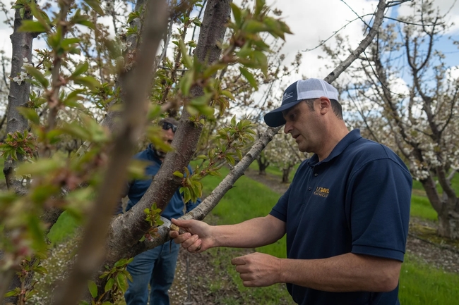
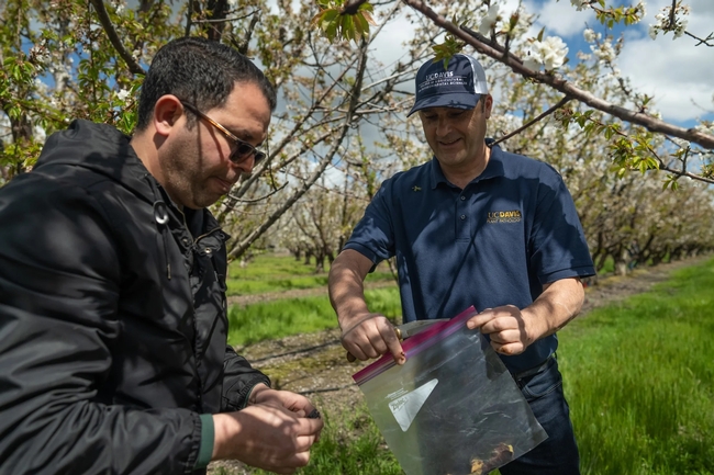
The visit starts like any consult in a doctor's office, only the questions come fast as they walk around the Lodi orchard where branches are dying, there is gumming and the trees appear stressed. Some look to be sunburned from exposure. Old pruning wounds show cankers, indicating that past disease treatments didn't get rid of whatever was affecting the trees.
Trouillas asks about the cultivar of the trees because some varieties are more susceptible to pests or diseases. He focuses on stress because that opens the door to disease.
Do they prune in the dormant winter months or in summer when pathogens are more prevalent? Does the soil get tested? How old are the trees? What about nutrition?
“I'm trying to figure out how they got infected so bad,” Trouillas said, walking the orchard. “Bacterial canker is a very mysterious disease.”
He thinks it might be a bacterial canker disease and shaves some bark to take to the lab for testing. He wants to come back next winter to take some samples to see where the pathogen is overwintering.
“We'll know in a few weeks if we have a fighting chance,” Vignolo said.
Be it Lodi, Fresno or elsewhere in the state, Trouillas focuses on local conditions. But what is learned in one field can be passed on to others, providing early warnings or advice for those in similar situations. “All these efforts at collaboration, from the field, to the lab, going through research projects, there's only one goal here — to help the farmers of California.”
Climate-Change Resources
University of California UC ANR Green Blog (Climate Change and Other Topics) https://ucanr.edu/blogs/Green/index.cfm?tagname=climate%20change (full index)
Examples:
- Save Trees First: Tips to Keep Them Alive Under Drought https://ucanr.edu/b/~CdD
- Landscaping with Fire Exposure in Mind: https://ucanr.edu/b/~G4D
- Cities in California Inland Areas Must Make Street Tree Changes to adapt to Future Climate https://ucanr.edu/b/~oF7
Drought, Climate Change and California Water Management Ted Grantham, UC Cooperative Extension specialist (23 minutes) https://youtu.be/dlimj75Wn9Q
Climate Variability and Change: Trends and Impacts on CA Agriculture Tapan Pathak, UC Cooperative Extension specialist (24 minutes) https://youtu.be/bIHI0yqqQJc
California Institute for Water Resources (links to blogs, talks, podcasts, water experts, etc.) https://ciwr.ucanr.edu/California_Drought_Expertise/
UC ANR Wildfire Resources (publications, videos, etc.) https://ucanr.edu/News/For_the_media/Press_kits/Wildfire/ (main website)
-UC ANR Fire Resources and Information https://ucanr.edu/sites/fire/ (main website)
-Preparing Home Landscaping https://ucanr.edu/sites/fire/Prepare/Landscaping/
UC ANR Free Publications https://anrcatalog.ucanr.edu/ (main website)
- Benefits of Plants to Humans and Urban Ecosystems: https://anrcatalog.ucanr.edu/pdf/8726.pdf
-Keeping Plants Alive Under Drought and Water Restrictions (English version) https://anrcatalog.ucanr.edu/pdf/8553.pdf
(Spanish version) https://anrcatalog.ucanr.edu/pdf/8628.pdf
- Use of Graywater in Urban Landscapes https://anrcatalog.ucanr.edu/pdf/8536.pdf
- Sustainable Landscaping in California https://anrcatalog.ucanr.edu/pdf/8504.pdf
Other (Non-UC) Climate Change Resources
Urban Forests and Climate Change. Urban forests play an important role in climate change mitigation and adaptation. Active stewardship of a community's forestry assets can strengthen local resilience to climate change while creating more sustainable and desirable places to live. https://www.fs.usda.gov/ccrc/topics/urban-forests
Examining the Viability of Planting Trees to Mitigate Climate Change (plausible at the forest level) https://climate.nasa.gov/news/2927/examining-the-viability-of-planting-trees-to-help-mitigate-climate-change/
Reports and other information resources coordinated under the auspices of the United Nations and produced through the collaboration of thousands of international scientists to provide a clear and up to date view of the current state of scientific knowledge relevant to climate change. United Nations Climate Action
Scientific reports, programs, action movements and events related to climate change. National Center for Atmospheric Research (National Science Foundation)
Find useful reports, program information and other documents resulting from federally funded research and development into the behavior of the atmosphere and related physical, biological and social systems. Search and find climate data from prehistory through to an hour ago in the world's largest climate data archive. (Formerly the "Climatic Data Center") National Centers for Environmental Information (NOAA)
Think tank providing information, analysis, policy and solution development for addressing climate change and energy issues (formerly known as the: "Pew Center on Global Climate Change"). Center for Climate & Energy Solutions (C2ES)
Mapping Resilience: A Blueprint for Thriving in the Face of Climate Disaster. The Climate Adaptation Knowledge Exchange (CAKE) was launched in July 2010 and is managed by EcoAdapt, a non-profit with a singular mission: to create a robust future in the face of climate change by bringing together diverse players to reshape planning and management in response to rapid climate change. https://www.cakex.org/documents/mapping-resilience-blueprint-thriving-face-climate-disaster
Cal-Adapt provides a way to explore peer-reviewed data that portrays how climate change might affect California at the state and local level. We make this data available through downloads, visualizations, and the Cal-Adapt API for your research, outreach, and adaptation planning needs. Cal-Adapt is a collaboration between state agency funding programs, university and private sector researchers https://cal-adapt.org/
Find reports, maps, data and other resources produced through a confederation of the research arms of 13 Federal departments and agencies that carry out research and develop and maintain capabilities that support the Nation's response to global change. Global Change (U.S. Global Change Research Program)
The Pacific Institute is a global water think tank that combines science-based thought leadership with active outreach to influence local, national, and international efforts to develop sustainable water policies. https://pacinst.org/our-approach/
Making equity real in climate adaptation and community resilience policies and programs: a guidebook. https://greenlining.org/publications/2019/making-equity-real-in-climate-adaption-and-community-resilience-policies-and-programs-a-guidebook/
Quarterly CA Climate Updates and CA Drought Monitor Maps (updated each Thursday) https://www.drought.gov/documents/quarterly-climate-impacts-and-outlook-western-region-june-2022

