The National Ecological Observatory Network (NEON) published this week airborne remote sensing data including full waveform and discrete return LiDAR data and LiDAR derivatives (DTM, DSM, CHM) as well as corresponding hyperspectral data, orthophotos, and field data on vegetation strucutre, foliar chemistry and ASD field spectra.
NEON Airborne Data Set.
From Sean's IGIS workshops this week.
Base Layers
- State of California Geoportal http://portal.gis.ca.gov/geoportal/catalog/main/home.page
- National Data Clearinghouse at Data.gov https://catalog.data.gov/dataset?organization_type=Federal+Government&metadata_type=geospatial&organization=fws-gov
- Topographic Quadrangle Maps http://atlas.ca.gov/quads/
- Soils http://casoilresource.lawr.ucdavis.edu/soilweb/
Land Cover and Wildlife Habitat
- California Department of Fish and Wildlife https://www.dfg.ca.gov/biogeodata/gis/map_services.asp
- Wildlife Habitat Relationships https://www.dfg.ca.gov/biogeodata/cwhr/
- GAP Analysis Land Cover Data http://gapanalysis.usgs.gov/gaplandcover/data/download/
- Wieslander Vegetation Type Mapping (VTM) http://vtm.berkeley.edu/#/data/
Imagery
- NAIP Imagery
- https://www.dfg.ca.gov/biogeodata/gis/map_services.asp
- http://www.atlas.ca.gov/download.html#/casil/imageryBaseMapsLandCover/imagery/naip
- Landsat Imagery http://earthexplorer.usgs.gov/
- MASTER (NASA’s Airborne ASTER/MODIS simulator) http://masterweb.jpl.nasa.gov/map/
Soils
- UC ANR California Soil Resource Lab http://casoilresource.lawr.ucdavis.edu/soilweb/
Climate and Weather Data
California Geopolitical Boundaries
- CA State Regional Water Board Jurisdictions http://www.waterboards.ca.gov/waterboards_map.shtml
- Assembly, Senate, Congressional, Equalization Districts http://wedrawthelines.ca.gov/maps-first-drafts.html
Digital Elevation Models
- ASTER DEM (30m) http://earthexplorer.usgs.gov/
- National Elevation Dataset (3, 10, & 30m)
- http://nationalmap.gov/elevation.html
- http://viewer.nationalmap.gov/viewer/
Congratulations to the NASA NEX Team! They have won the 2014 HPCwire Readers’ & Editors’ Choice Award for the Best Data-Intensive System (End User focused). See the article here: NASA Earth Exchange (NEX) Platform supports dozens of data-intensive projects in Earth sciences.
The NASA Earth Exchange (NEX) platform supports dozens of data-intensive projects in Earth sciences, bringing together supercomputers and huge volumes of NASA data, and enabling scientists to test hypotheses and execute modeling/analysis projects at a scale previously out of their reach. NEX-supported applications range from modeling El Niño, creating neighborhood-scale climate projections, assisting in crop water management, and mapping changes in forest structure across North America, to mapping individual tree crowns at continental scale as a foundation for new global science at unprecedented spatial resolution. NEX’s OpenNEX challenge ties in to White House initiatives, including Open Data, Big Data and Climate Data, which advance national goals to address climate change impacts and include competitions and challenges to foster regional innovation.
The GIF has been partnering with NASA NEX, and developing a framework to bring NEX data and analytical capabilities into HOLOS.


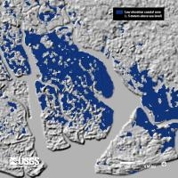
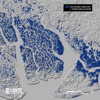
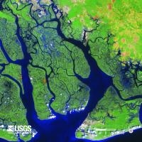
Just in time for class on topography and rasters tomorrow: new high res shuttle DEM data is being released for Africa. The image above shows the Niger River Delta in 90m res, 30m res, and landsat.
From the press release: In Africa, accurate elevation (topographic) data are vital for pursuing a variety of climate-related studies that include modeling predicted wildlife habitat change; promoting public health in the form of warning systems for geography and climate-related diseases (e.g. malaria, dengue fever, Rift Valley fever); and monitoring sea level rise in critical deltas and population centers, to name just a few of many possible applications of elevation data.
On September 23, the National Aeronautics and Space Administration (NASA), the National Geospatial-Intelligence Agency (NGA), and the U.S. Geological Survey (USGS, a bureau of the U.S. Department of the Interior) released a collection of higher-resolution (more detailed) elevation datasets for Africa. The datasets were released following the President’s commitment at the United Nations to provide assistance for global efforts to combat climate change. The broad availability of more detailed elevation data across most of the African continent through the Shuttle Radar Topography Mission (SRTM) will improve baseline information that is crucial to investigating the impacts of climate change on African communities.
Enhanced elevation datasets covering remaining continents and regions will be made available within one year, with the next release of data focusing on Latin America and the Caribbean region. Until now, elevation data for the continent of Africa were freely available to the public only at 90-meter resolution. The datasets being released today and during the course of the next year resolve to 30-meters and will be used worldwide to improve environmental monitoring, climate change research, and local decision support. These SRTM-derived data, which have been extensively reviewed by relevant government agencies and deemed suitable for public release, are being made available via a user-friendly interface on USGS’s Earth Explorer website.
Nice slider comparing the 90m to the 30m data here.
- Author: Shane Feirer
The California Climate Commons (http://climate.calcommons.org/) will be hosting a new version of the California Basin Characterization Model, sometimes called the BCM or Flint data (after the modelers, Lorraine and Alan Flint). The new version of the BCM is currently being processed and is planned to be hosted by California Climate Commons in the next month. Lorraine Flint discusses what's new in this dataset in the following Forum. California Climate Commons will be hosting the California model outputs initially and a Nevada dataset will be added later this year. This new dataset features 18 modeled futures; you can read the California Climate Commons article called "Why So Many Climate Models?" to find out more about them as well as learn about how to work with the large number of climate models that are available.


