
I don't use ocean color data, but found this report of interest nonetheless. From the HICO website. HICO is the Hyperspectral Imager for the Coastal Ocean.
HICO Operations Ended. March 20, 2015 In September 2014 during an X-class solar storm, HICO’s computer took a severe radiation hit, from which it never recovered. Over the past several months, engineers at NRL and NASA have attempted to restart the computer and have conducted numerous tests to find alternative pathways to communicate with it. None of these attempts have been successful. So it is with great sadness that we bid a fond farewell to HICO. Yet we rejoice that HICO performed splendidly for five years, despite being built in only 18 months from non space-hardened, commercial-off-the-shelf parts for a bargain price. Having met all its Navy goals in the first year, HICO was granted a two-year operations extension from the Office of Naval Research and then NASA stepped in to sponsor this ISS-based sensor, extending HICO’s operations another two years. All told, HICO operated for 5 years, during which it collected approximately 10,000 hyperspectral scenes of the earth. Most of the HICO scenes taken over sites worldwide are available now, and will remain accessible to researchers through two websites: http://oceancolor.gsfc.nasa.gov/ and http://hico.coas.oregonstate.edu. HICO will live on through research conducted by scientists using HICO data, especially studies exploring the complexities of the world’s coastal oceans.


The National Ecological Observatory Network (NEON) published this week airborne remote sensing data including full waveform and discrete return LiDAR data and LiDAR derivatives (DTM, DSM, CHM) as well as corresponding hyperspectral data, orthophotos, and field data on vegetation strucutre, foliar chemistry and ASD field spectra.
NEON Airborne Data Set.

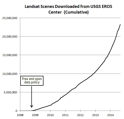
They found that the economic value of just one year of Landsat data far exceeds the multi-year total cost of building, launching, and managing Landsat satellites and sensors. This would be considered a stunning return on investment in any conventional business setting.
Full article by Jon Campbell, U.S. Geological Survey found here.


The researchers built the cropland database by combining information from several sources, such as satellite images, regional maps, video and geotagged photos, which were shared with them by groups around the world. Combining all that information would be an almost-impossible task for a handful of scientists to take on, so the team turned the project into a crowdsourced, online game. Volunteers logged into "Cropland Capture" on a computer or a phone and determined whether an image contained cropland or not. Participants were entered into weekly prize drawings.


The images show some 3,700 structures damaged or destroyed in Baga and Doron Baga this month, Amnesty said. This is in stark contrast with goverment estimates of destruction.
The BBC's Will Ross says that while the images show the destructive nature of Boko Haram, they do not help establish just how many people were killed.
Last week, Musa Alhaji Bukar, a senior government official in the area, said that fleeing residents told him that Baga, which had a population of about 10,000, was now "virtually non-existent".

