Hi all! I was recently profiled for the excellent website: Women in GIS (or WiGIS). This is a group of technical-minded women who maintain this website to feature women working in the geospatial industry with our Who We Are spotlight series. and in addition, the individuals in this group make their presence known at conferences like CalGIS and ESRI’s UCs. We also plan to host a number of online resources women might find useful to start or navigate their GIS career.
Excellent idea, and thanks for the opportunity!
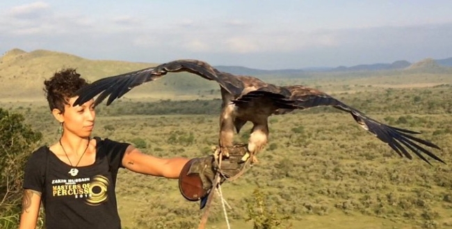
Christine Wilkinson reports here on her trip to East Africa as part of her dissertation research. She explored potential field sites, networked with communities and wildlife managers, and brainstormed my dissertation research questions. And took some amazing pics. http://africa.berkeley.edu/situated-brainstorming

Last week we held another bootcamp on Spatial Data Science. We had three packed days learning about the concepts, tools and workflow associated with spatial databases, analysis and visualizations. Our goal was not to teach a specific suite of tools but rather to teach participants how to develop and refine repeatable and testable workflows for spatial data using common standard programming practices.
On Day 1 we focused on setting up a collaborative virtual data environment through virtual machines, spatial databases (PostgreSQL/PostGIS) with multi-user editing and versioning (GeoGig). We also talked about open data and open standards, and moderndata formats and tools (GeoJSON, GDAL). On Day 2 we focused on open analytical tools for spatial data. We focused on Python (i.e. PySAL, NumPy, PyCharm, iPython Notebook), and R tools. Day 3 was dedicated to the web stack, and visualization via ESRI Online, CartoDB, and Leaflet. Web mapping is great, and as OpenGeo.org says: “Internet maps appear magical: portals into infinitely large, infinitely deep pools of data. But they aren't magical, they are built of a few standard pieces of technology, and the pieces can be re-arranged and sourced from different places.…Anyone can build an internet map."
All-in-all it was a great time spent with a collection of very interesting mapping professionals from around the country. Thanks to everyone!
I wanted to send out a friendly reminder that the data submission deadline for the current data call is March 31, 2016. Data submitted before March 31 are evaluated for inclusion in the appropriate update cycle, and submissions after March 31 are typically considered in subsequent updates.
This is the last call for vegetation/fuel plot data that can be used for the upcoming LANDFIRE Remap. If you have any plot data you would like to contribute please submit the data by March 31 in order to guarantee the data will be evaluated for inclusion in the LF2015 Remap. LANDFIRE is also accepting contributions of polygon data from 2015/2016 for disturbance and treatment activities. Please see the attached data call letter for more information.
Brenda Lundberg, Senior Scientist
Stinger Ghaffarian Technologies (SGT, Inc.)
Contractor to the U.S. Geological Survey (USGS)
Earth Resources Observation & Science (EROS) Center
Phone: 406.329.3405
Email: blundberg@usgs.gov
Register now for the March 2016 Spatial Data Science Bootcamp at UC Berkeley!
We live in a world where the importance and availability of spatial data are ever increasing. Today’s marketplace needs trained spatial data analysts who can:
- compile disparate data from multiple sources;
- use easily available and open technology for robust data analysis, sharing, and publication;
- apply core spatial analysis methods;
- and utilize visualization tools to communicate with project managers, the public, and other stakeholders.
To help meet this demand, International and Executive Programs (IEP) and the Geospatial Innovation Facility (GIF) are hosting a 3-day intensive Bootcamp on Spatial Data Science on March 23-25, 2016 at UC Berkeley.
With this Spatial Data Science Bootcamp for professionals, you will learn how to integrate modern Spatial Data Science techniques into your workflow through hands-on exercises that leverage today's latest open source and cloud/web-based technologies. We look forward to seeing you here!
To apply and for more information, please visit the Spatial Data Science Bootcamp website.
Limited space available. Application due on February 19th, 2016.


