- Author: Shane Feirer
Have you ever wanted to work with climate change data? Last week I took a workshop from the UC Berkeley Geospatial Innovation Facility (GIF) titled "Working with Climate Data (link). This workshop showed how to work with climate data hosted by the GIF in their Climate App (Cal-Adapt) and other climate data hosted as NetCDF datasets. Through this workshop we learned how to use jupyter notebooks and the python language to query and analyze these types of data. The workshop also highlighted the use of NetCDF data within ArcGIS Pro and its new multidimensional charting tools.
I recommend this training and other trainings held at the GIF. I look forward to applying these new tools in my work with IGIS.
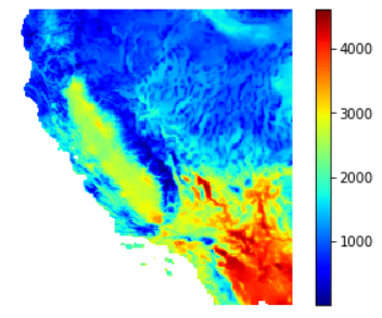
The image below is the Growing Degree Days calculation for 2013 with a 10 degree C base, that I was able to develop with techniques used at this workshop.
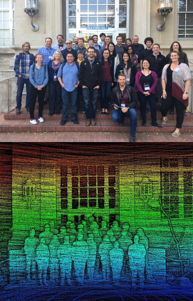
Our third GIF Spatial Data Science Bootcamp has wrapped! We had an excellent 3 days with wonderful people from a range of locations and professions and learned about open tools for managing, analyzing and visualizing spatial data. This year's bootcamp was sponsored by IGIS and GreenValley Intl (a Lidar and drone company). GreenValley showcased their new lidar backpack, and we took an excellent shot of the bootcamp participants. What is Paparazzi in lidar-speak? Lidarazzi?

Here is our spin: We live in a world where the importance and availability of spatial data are ever increasing. Today’s marketplace needs trained spatial data analysts who can:
- compile disparate data from multiple sources;
- use easily available and open technology for robust data analysis, sharing, and publication;
- apply core spatial analysis methods;
- and utilize visualization tools to communicate with project managers, the public, and other stakeholders.
At the Spatial Data Science Bootcamp we learn how to integrate modern Spatial Data Science techniques into your workflow through hands-on exercises that leverage today's latest open source and cloud/web-based technologies.
Spatial Data Science for Professionals
- integrating disparate data, from aircraft, satellites, mobile phones, historic collections, public records, the internet;
- using easily available and open technology for robust data analysis, sharing, and publication;
- understanding and applying core spatial analysis methods;
- and applying visualization tools to communicate with project managers, policy-makers, scientists and the public.
Mastering these challenges requires Spatial Data Science: big data tools, geospatial analytics, and visualization. Today’s marketplace needs trained analysts who know how to find, evaluate, manage, analyze and publish spatial data in a variety of environments. With this hands-on Spatial Data Science Bootcamp for professionals, you can expand your GIS skill level and learn how to integrate open source and web-based solutions into your GIS toolkit by gaining an understanding of spatial data science techniques.
The goal of this Spatial Data Science Bootcamp is to familiarize participants with the modern spatial data workflow and explore open source and cloud/web based options for spatial data management, analysis, visualization and publication. We’ll use hands-on exercises that leverage open source and cloud/web based technologies for a variety of spatial data applications.
https://iep.berkeley.edu/spatial/iep-spatial-bootcamp-overview
Spring 2016 GIF Workshops
The Geospatial Innovation Facility is excited to announce that we will be offering our standard workshops series for FREE this spring to UC Berkeley students, faculty, and staff. Currently we still need to retain our pricing of $224 for all non-UC affiliates. However, space is limited and the workshops will be filled on a first-come first-served basis, so register today at to take advantage of these great training opportunities!
GIF workshops offer hands-on applications oriented training in a variety of geospatial topics. Our Introduction to Geographic Information Systems (GIS) and Introduction to Remote Sensing workshops are designed for participants with little to no experience in GIS, or those who would like to refresh their geospatial skills. Each workshop teaches core geospatial principals and techniques through a combination of lecture and hands-on interactive activities.
We are currently accepting registration for our introductory series of workshops offered over the next several weeks. See more detailed descriptions and register for any of the upcoming trainings at: http://gif.berkeley.edu/support/workshops.html
January 29: Intro to GIS: Social Science Focus
The presentation will get you up to speed on what kind of analyses GIS may be used for, as well as the basic structures of spatial data. After the lecture you will follow an interactive exercise that has been designed to introduce you to ArcGIS Desktop software while analyzing street and census data around the City of Berkeley.
February 5: Intro to GIS: Environmental Science Focus
The presentation will get you up to speed on what kind of analyses GIS may be used for, as well as the basic structures of spatial data. After the lecture you will follow an interactive exercise that has been designed to introduce you to ArcGIS Desktop software while analyzing environmental data from around Lake Tahoe.
February 12: Intro to Open Source GIS: Using QGIS
QGIS is a free and open source geospatial desktop application that has been developing at a rapid pace. Its ease of use and accessibility (available for PC, Mac, and Linux platforms) has created a strong and active user community. In this workshop, we will explore the basic functionality of QGIS so that you may quickly learn how to load and format vector and raster data, edit shapefiles, and query attributes.
February 19: Intro to GIS for Agriculture: Rangeland Focus
An introductory presentation will get you up to speed on what kind of analyses GIS may be used for, as well as the basic structures of spatial data. After this brief lecture you will follow an interactive exercise that will introduce you to using free and open source online data to analyze and map rangelands in the California Central Valley.
February 26: Intro to Remote Sensing: Understanding Digital Imagery
This workshop introduces basic principles of understanding digital imagery, both satellite and aerial. Through a combination of lecture and interactive activities, we will explore what makes up a multi-spectral image, where to find and download them, and how to view and manipulate imagery.
These workshops are held in 124 Mulford Hall and run from 1pm – 4:30pm. Sign-up now for this great opportunity for intensive, hands-on training in geospatial methods, tools, and analysis!
- Author: Shane Feirer
IGIS goes to the ESRI Open GeoDev Hacker Lab at the University of California Berkeley – GIF on January 15th. ESRI came to the GIF to demonstrate their open tools and data. We were able to create free developer accounts at http://developers.esri.com, with these accounts were able to create feature layers that could be used in webmaps, webapps, and mobile apps hosted by ESRI through ArcGIS online. We also learned how to use these services with other open web mapping tools such as leaflet. With a little javascript programming and patience it seems like the sky is the limit when it comes to what we could create with these tools. In the future IGIS plans to develop a training on using the ArcGIS Online system to its fullest potential and some of the things we learned at this event will be included in the training as well.
Thank you to ESRI and the GIF for making this training opportunity possible.


