- Author: Andrew J Lyons
- Contact: Sean D Hogan
June 24-28, 2024
CSU Monterey Bay
(plus virtual open)
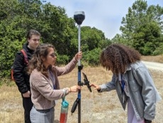
DroneCamp is a premiere five-day training program that covers everything you need to know to use drones for mapping and data collection.
Curriculum at a Glance
- equipment
- safety & regulations
- flight planning
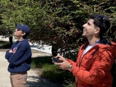
- manual & autonomous flight
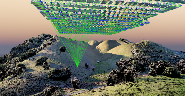
- photogrammetry
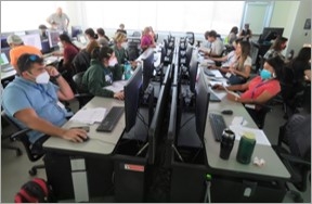
- hands-on data processing with Pix4D, OpenDroneMap & ArcGIS Pro
- data analysis & visualization
- research talks & use cases
- educator track - new for 2024!
Now in its eighth year, Drone Camp 2024 will once again provide a unique drone training opportunity designed for a wide range of skill levels and interests, from complete beginners with little to no experience in drone technology, to intermediate users who want to learn more advanced data processing and analysis.
DroneCamp started out as an IGIS workshop, but has evolved into a highly collaborative program with instructors coming from 8 campuses including UC ANR, UC Merced, UC Santa Cruz, CSU Monterey Bay, UC Davis, UC Berkeley, UC Santa Barbara, Lakeland College, and American River College.
DroneCamp 2024 will be held in-person at CSU Monterey Bay June 24-28, 2024. Scholarships to cover the registration fee are available for all ANR academics and staff - but you must apply soon! More info available at DroneCampCA.org.
 |
 |
 |
 |
- Author: Sean Hogan
- Author:
Ben Satzman
- Author: Maggi Kelly
July 2021 marks the fifth anniversary of Drone Camp, and thanks to an all-star lineup of presenters and instructors and a fantastic and diverse group of over 255 attendees from all over the world, it was a massive success this year. Initially launched in 2016 by the UC ANR, IGIS Statewide program, DroneCamp has now evolved into a multi-campus and industry collaboration, with a network of drone experts hailing from UC ANR, UC Santa Cruz, UC Berkeley, UC Merced, UC Davis, CSU Monterey Bay, and the Monterey Bay Drone Automation and Robotics Technology corporation. From 2016 to 2019, this event was held in-person at Davis, San Diego, and then in Monterey, CA.; however, in 2020 it was moved online due to COVID-19. The move indoors, to discuss a very outdoor-oriented topic, came with some challenges. We had to shelve our important (and fun) hands-on equipment and flight training, for example. Yet it had rewards. We were able to reach a more diverse and a greater number of participants, and widen the scope of content. Ultimately, 2020 was a great success, but in the process we recognized that it could be even better with additional help from our network of drone expert friends from around the state.
Like last year, we came together online for DroneCamp 2021 in July. Over 255 people joined from around the world to learn about theory, application, regulation, and data processing. We learned about the practical aspects of maintaining safety while flying, we took deep dives into various software workflows, and explored agricultural, forestry, and vegetation mapping examples. This year we hosted 5 Plenary sessions, and had some electrifying plenary talk sessions from cutting-edge scientists from around California: Crashing drones! Precision Agriculture! Citizen Science! Mapping aquatic environments!
Because the overall objective of DroneCamp remains to provide the most practical and comprehensive learning experience possible for attendees, we are working on an in-person, hands-on training day that is being scheduled for October, to be held in Monterey/Marina California. And, as the threat of COVID-19 subsides, additional in-person training sessions will be added around the state of California in the coming year.
DroneCamp Overview:
DroneCamp is designed for a wide range of skill levels and interests, for those who are interested in using drones for anything other than non-recreation use (calling for a part 107 remote pilot's license), from complete beginners with little to no experience in drone technology, to intermediate users who want to learn more advanced data processing and analysis. Between presentations on contemporary applications of drones in environmental and agricultural research, and hands-on data processing and analysis exercises, attendees have the opportunity to fully immerse themselves in the following topics:
-
Flight Skills: Safe Launch and Landings, Basic Operations, Traversing and Avoiding Obstacles, Night Flying
-
Safety and Regulations: Safety and Regulations Overview; How to be a Good Visual Observer; Operating in Controlled Airspace
-
Hardware: Sensors, Platforms and Field Accessories
-
Data Collection: Mission Planning; High Precision Mapping
-
Data Processing: Stitching Drone Images with Pix4D, Agisoft Metashape, ArcGIS Pro, and OpenDroneMap; Analyzing Processed Drone Data in QGIS and ArcGIS Pro
-
Data Analysis and Management: Vegetation Analysis, Vegetation Analysis and Classification in ArcGIS Pro;Analysis of the Intertidal Zone; A case study of data management, from collection to storage and sharing of data outputs.
It was super fun and rewarding, and a great success for ANR and all the other collaborators. We built networks, increased collaboration, learned some very cool technical stuff, and got updated on current regulations, including the fact that you can now renew your 107 license easily here.
Some inspiring quotes from anonymous attendee reviews:
I was so appreciative of the extremely high caliber faculty/instructors that were recruited to give presentations, demos, and use of software. You all worked so well together to impart different pieces of expert knowledge. You all are brilliant and I'm inspired!!!
Loved it. We started off heavy which blew my mind but all the talks were so informative and fascinating. Really appreciate the diverse group of people you gathered together. Just wish it was in person! I would love to meet everyone.
Excellent presentation that allowed those of us with ArcMap experience to see the similarities and differences offered by ArcGis Pro. Again, a wonderful presentation (by a professional) that accounts for all the practical steps involved with data manipulation rolled into a final product.
Once I read through my notes, look at my screen captures and watch some of the presentations again, I will be able to structure my drone classes for my students. I'm developing a drone program from scratch for middle and high school students at a local charter school.
Consider signing up for the in-person training in October, and keep DroneCamp 2022 in your sights! Further information will be coming soon to the DroneCamp website, https://dronecampca.org/
- Author: Andy Lyons
- Contributor: Sean Hogan
- Contributor: Nina Maggi Kelly
Like many things that start small and then go viral, the growth of DroneCamp has been welcome but challenging to sustain. The situation just got a whole lot better thanks to a grant from the UC Vice President for Research and Innovation.
DroneCamp was developed and launched in 2017 by the Informatics and GIS program in UC ANR. From the very beginning, the multi-day bootcamp style short course was designed to be highly collaborative and dynamic, with instructors coming from UC ANR, the UC Unmanned Aircraft System Safety center, and drone photogrammetry companies including Pix4D and ESRI. This was not only strategic for building long-term working relationships among campuses and the private sector, but also necessary. The expertise needed to use drones for mapping and data collection is scattered across departments and campuses, and no one unit has the resources to cover all the bases.
Over the next few years, the program grew by leaps and bounds as we went "on the road" to UC San Diego in 2018 and CSU Monterey Bay in 2019. Each year the class size, curriculum, and program complexity grew. In San Diego, the program was hosted by the UCSD Environmental Health and Safety office, with additional sessions by the UCSD Drone Lab; one of the most advanced drone labs in the UC system. DroneCamp 2019 represented a step increase in collaboration, thanks in large part to the efforts of UC ANR Vice President Glenda Humiston who connected us with Monterey Bay DART (Drones, Automation and Robotics Technology), a technology-focused economic development program based out of the nascent UC Monterey Bay Education Science & Technology Center (UCMBEST). The Institute for Innovation & Economic Development at CSU Monterey Bay, under Dean Andrew Lawson, hosted the event, opening their doors to a new academic building and an extremely modern computer lab. Flight training was held at the nearby UC NRS Fort Ord Natural Reserve, managed by UC Santa Cruz. The whole program was planned to coincide with an industry symposium implemented by DART, so that the day after the instructional sessions concluded we shifted gears to an invigorating all-day symposium on technology, policy, and regional economic development.
The scope of DroneCamp took another great leap forward in 2020, when the virtual format blew the lid off the scale and breadth of instructors, workshop topics, and participants. The talented pool of instructors in 2020 (most of whom are returning for DroneCamp 2021), hailed from across California and as far away as Ohio, including:
- UC ANR
- CSU Monterey Bay
- UC Merced
- UC Santa Cruz
- UC Davis
- UC Berkeley
- UC NRS
- Palomar College
- Open Drone Map consortium
The virtual format not only allowed the Planning Committee to expand the core instructional content covering the deep workflow of drone mapping, but we were also able to add panels in specific research applications including coastal environments and agriculture, as well as industry perspectives and technology updates. To manage the load of what was now a medium sized instructional conference, IGIS developed a custom content management system which included an automated registration dashboard to handle the many concurrent Zoom sessions. The beneficiaries of this growth included the over 330 people from 5 countries, but also the expanding network of instructors, researchers, and industry partners.
Growing however comes with costs, and although the success has been rewarding, the complexity of the program has become increasingly unwieldy for the ad hoc Planning Committee to strategically plan and coordinate. Which is why we're thrilled to share that a recent research innovation grant to UC Santa Cruz from UC Vice President for Research and Innovation Theresa Maldonado will support UCSC's growing drone program, including coordination support for DroneCamp. The new funding will allow Dr. Justin Cummings, a UAS operator and data analyst with the California Heartbeat Initiative, to spend more time coordinating the many moving parts of DroneCamp, and support the Planning Committee in continuing to deliver what has evolved over the last 5 years into one of the premiere drone mapping training events in the country.
The support and stability will also allow the Planning Committee to make inroads on some long-standing programming goals. These include developing a stronger needs assessment and evaluation framework, connecting with workforce development initiatives and continuing education programs, expanding fundraising and sponsorships, reviving the scholarship program for under-represented groups, organizing panels that bring together scientists, industry leaders, and funders, and packaging instructional materials into extension products that can be used in other settings as well as asynchronous learning.
The future of DroneCamp is bright, and 2021 should be another information packed week of drone technology and data analysis. So get your propellers on, clear some space on your hard drive, and plan to come to DroneCamp July 26-30, 2021.
DroneCamp Planning Committee:
- Sean Hogan, UC ANR IGIS Program
- Justin Cummings, UC NRS, UCSC
- Brad Barbeau, CSU Monterey Bay
- Chris Bley, InsightUp Solutions
- Becca Fenwick, UC NRS, UCSC
- Corey Garza, CSU Monterey Bay
- Pat Iampietro, CSU Monterey Bay
- Maggi Kelly, UC ANR IGIS Program
- Andy Lyons, UC ANR IGIS Program
- Michael Matkin, UC Santa Cruz
- Josh Metz, DART
- Mallika Nocco, UC ANR
- Brandon Stark, UC Merced
- Author: Hannah Lopez
- Author: Andy Lyons
2020: DroneCamp Goes Virtual
ONLINE
In June 2020, IGIS hosted the 4th annual DroneCamp in collaboration with CSU Monterey Bay, the UC Unmanned Aircraft System Safety office, and Monterey Bay DART. The four-day intensive bootcamp aims to cover the full spectrum of skills and tools needed to collect data and make maps with drones.
Due to COVID19, DroneCamp 2020 was held entirely online. We couldn't teach flight practice over Zoom, but other than that the curriculum covered the usual suite of topics including regulations and safety, equipment, flight planning, photogrammetry, and data analysis.
The online format wasn't nearly as fun as meeting in person at CSU Monterey Bay, but it produced some unexpected benefits. Over 330 people attended the program from all over the US, Canada and several other countries. Attendees came from a wide range of backgrounds including education, natural resource management, resource conservation, agriculture, real estate, construction, and archeology.
The pool of presenters and instructors also diversified both geographically and programmatically. Instructors came from several universities across California and beyond, and an expanded set of research talks covered a range of topics including workforce development, coastal and marine systems, and digital agriculture.
Session Recordings Now on YouTube!
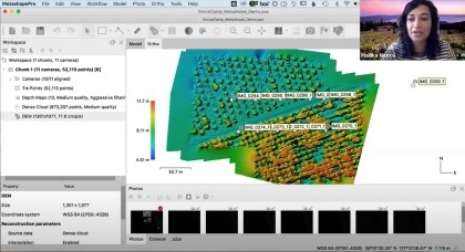
You can access the sessions via the DroneCamp Online Program, or the DroneCamp 2020 Playlist on the IGIS YouTube Channel. The Online Program also contain links to presentation slides, exercise handouts, and datasets.

Organizing and editing all the videos for production was no small feat, and the DroneCamp team is excited to make these resource materials accessible to everyone who would like to learn more about the world of UAV technology. If you find them useful, or would like to get involved in future training on drone mapping, please leave a comment or send us a note.
Many Thanks
IGIS would like to extend their gratitude to the many collaborators who made this years online conference possible: UC ANR Program Support Unit; UC ANR Integrated Pest Management program, UC ANR Learning & Development unit; Wilder Interpreting Services; Monterey Bay DART; the FAA Collegiate Training Initiative; and, of course, all our instructors, presenters, and participants. Thanks!
- Author: Andy Lyons
The Decision to Go Online. When COVID-19 struck, the DroneCamp Planning Committee had to quickly decide how to respond when it became apparent an person-event would not be possible. By the time we officially canceled the in-person event in early April, registration had already started. We had a couple weeks to decide - do we cancel? Postpone? Hold it virtually?
Given the amount of planning that had already been invested (we started meeting in October 2019), and the fact that only one component (flight practice) would not translate at all to a virtual format, the Committee decided to move forward with an online event. We were admittedly intrigued by the possibilities of an online format, including a potentially larger audience. I was equally excited about the potential for an expanded pool of instructors, as we had been trying for years to get colleagues from distant campuses to participate. We were torn whether to maintain the same 3-day time frame, or spread it out over several weeks as some virtual conferences are doing. We ultimately decided to maintain the same one-week time frame, in part because instructors had already committed to those days. To mitigate Zoom fatigue, we aimed to limit programming to 2-3 hours each morning and 2 hours afternoon. Sessions would be scheduled on the early side to accommodate potential participants on the east coast.
A Need for New Coordination Technology. After committing ourselves to an online event, the details and requirements for what we needed started to hit me. To manage such an ambitious program, we needed a way to coordinate workshop info, software instructions, and exercise materials involving nearly two dozen instructors, and share everything in a clear and organized manner with a couple hundred participants (which in the end grew to over 300). We also needed a way to manage registration for multiple Zoom sessions, including Webinars for the plenaries and concurrent Meetings for the hands-on software workshops.
Having been thru this rodeo before, I knew two lessons for a successful conference. First, the key to a successful collaborative event is not just catering to the needs of participants, but equally if not more importantly your presenters. Second, almost everyone - instructors and participants alike - waits until the 11th hour to pay attention. Hence whatever tool, or set of tools, we used, they had to be user-friendly and as automated as possible so that last minute changes could be accommodated with a minimum of manual steps.
Specifically, I needed to create three information tools:
- An Online Program, consisting of a mix of content from the Committee as well as instructors, that can be be updated quickly, and capable of sharing including a variety of links for slides, data, Zoom, etc.
- A way for people to sign-up for concurrent workshops, and get individualized Zoom links after cross-checking their registration status.
- A customized summary of participants generated from registration data from the ANR survey platform
Ideally, we would have had a Learning Management System to use, or at least an event planning platform to build upon. That was not our case, so I had to turn to my go-to tool stack of DIY solutions: Google App Scripts, R, markdown, and Github.


The Online Program
An online event needs an online program. DroneCamp in particular needed a program that could be quickly updated before and during the event, was user-friendly for instructors to update their session info, and combined a range of both static and dynamic content including session titles and descriptions, thumbnail images, scheduling info, and links for slides, exercises, datasets, and Zoom.

To make life as easy-as-possible for busy instructors, I pre-populated as much of each session info as I could, including draft session titles and descriptions. Knowing that session description would need links to software installation instructions and other details, I created the equivalent of auto-text fields that when rendered by my R script were replaced with values stored on a different tab in the Google Sheet.


Knowing that GitHub occasionally goes down, or could theoretically throttle our site if there was too much traffic, I created a backup site on an Ubuntu web server that IGIS manages. Fortunately we never needed to use it, but it was good to have a Plan B.

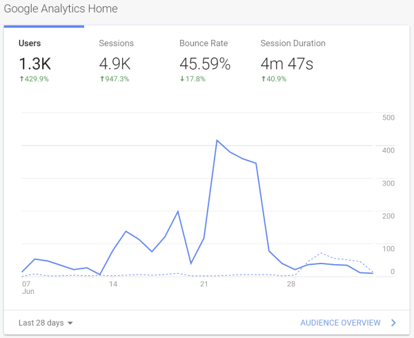
Page views are just tip of the iceberg from Google Analytics. I don't have a huge amount of experience with Google Analytics, but hope to dig into this some more for next time to see what else I can glean about our users. Another area for future development is implementing click tracking, which Google Analytics supports, to learn more about how people are using the site.
Creating a Zoom Registration Dashboard
Probably our biggest headache was managing the multiple Zoom sessions. Our requirements were more complex than your average webinar as we need to:
- Manage a combination of Zoom Webinars (for plenary talks), and Zoom Meetings (for the hands-on software workshops). To complicate things further, we only had access to 1 webinar license (which we couldn't use the entire time because of other commitments), so had to ask colleagues to schedule webinars for us. We also needed up to 5 concurrent Zoom meetings for demos, meaning 5 different hosts.
- Make use of Zoom's registration features, to ensure only registered participants could join and prevent Zoombombers
- Provide a mechanism for participants to sign-up for concurrent workshops, and receive individualized Zoom links for the appropriate session after cross-checking their registration status
- Minimize additional registration steps participants had to complete, including registering for multiple Zoom meetings.
Biggest Challenge: Managing Zoom Meeting Registration. In the 3 months leading up to DroneCamp, we learned a lot about Zoom's dizzying array of dials and levers for meetings, webinars, user accounts, and the Zoom client. My biggest challenge was how to register 300+ people for roughly 8 concurrent Zoom meetings, preferably without asking them to click on individual Zoom registration links. This was a fairly big hurdle because unlike Zoom webinars, the Zoom website does not provide a way to upload a CSV file of registrants for a Meeting. Additionally, I needed a solution that would cross-check our DroneCamp registration list, and send individualized connection links. All of this had to be done as efficiently as possible to cater for the dozens I knew would not read any of our emails until after the opening session, and accommodate people who would inevitably change their mind after the course started.

Strike 2: Third Party API Integration Services. Next, I turned to the Zoom API, beginning with the dozens of third party integration services (e.g., automate.io, integromat, appypie.com, hull.io, tray.io). These platforms serve as the connective tissue for all manner of online services and web apps, because they help you integrate your various web APIs (like Google Sheets and Zoom). These platforms are not free, but they're easy to set up and use so if I found one that would get the job done it would be a small price to pay. Reading through the details however, I discovered they mostly supported Zoom webinars, not meetings, and few if any of them supported registration management. Another dead end.
But the authentication step is daunting. The simplest way to authenticate a custom Zoom App is creating a Java Web Token (JWT), which is the equivalent of sending a password. But that option was not available to me because our organizational ANR Zoom account is locked down for security reasons and I'm not an administrator. Thus I had to go with a user authentication approach using an OAuth protocol, which requires programming a complex ‘dance' between login page, redirects, IP white lists, and secret client keys and tokens under the hood. One would think there would be ample examples of authenticating Zoom's enormously popular API from Google's enormously popular Google Apps platform, but such is not the case. After a couple of late nights of stringing together various chunks of sample code, and playing whack-a-mole with cryptic error codes and configuration settings, I finally got it to work. I knew I could now create custom menus in Google Sheets to schedule new Zoom meetings, define their properties, and register people for them.
The next step was to integrate this new capability into a Google Sheets app for DroneCamp. The Google Sheet serves as the 'hub' for several Google Forms, our registration data, and Zoom. It uses conditional formatting, a whole bunch of VLOOKUP and IMPORTRANGE functions, and a Custom menu with a sidebar GUI to manage the Zoom functions. I called the result the Zoom Dashboard.
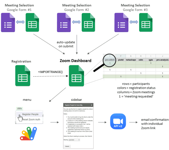
Each column of the Zoom Dashboard represents a Zoom meeting, and each row represents a participant. When a DroneCamp participant submits the Concurrent Session Sign-up form, a script runs putting a ‘1' in the corresponding column of the Zoom dashboard. The Zoom dashboard also had a copy of the ANR Registration Survey, and a combination of VLOOKUP functions and conditional formatting rules to flag people who did not have a matching registration. As Administrator, I could quickly check the registration status of people who requested a particular workshop, change the ‘1' to another code if needed, and then when everything was good run a menu command to actually register people for the meeting.
The key to creating an interactive Google Sheets App is using sidebars to present the user with a GUI. I had never programmed sidebars before but have seen them used a lot including many Google Sheets Addons. After another night of reading documentation and programming, I eventually figured it out. Behind the scenes, a sidebar is simply an HTML template with form elements that are configured to execute Google Apps functions. This gives you enormous flexibility both in terms of layout as well as functionality, pretty cool.
The system worked fairly well, and the vast majority of participants got their Zoom links quickly and in ample time. Last minute changes in workshop preferences were dealt with relative ease. It took less than a minute to review new workshop requests, validate them, and run the registration script. A small number of participants had recurring hiccups due primarily to problems on their end including, i) registering with multiple email address despite being told repeatedly not to do so, ii) making typos in their email addresses (shockingly common), or iii) failing to take the recommended steps to prevent Zoom confirmation emails getting flagged as spam. Our phenomenal PSU staff were the frontline dealing with questions about Zoom; but I intercepted many of these issues by first flagging problematic entries with conditional formatting rules on the Google Sheet, and then investigating them on a case-by-case basis.
Other features for the Zoom Dashboard that I ran out of time to implement included writing a script that would extract a participant's individual Zoom links for multiple meetings and send them in a single email. That would be extremely useful for an event like ours with so many sessions. I also had plans to write an auto-reminder email for Zoom meetings, another feature that Zoom only provides for Webinar licenses but can be done via the API.
Summary of Participants
We used the in-house ANR Survey System for registration and payment. Similar to platforms like Eventbrite, the ANR Survey Tool provides a highly customizable registration form linked to multiple payment options (including inter-campus transfers). Unlike Eventbrite however, this older tool doesn't have a built-in report generator, nor an API providing access to the underlying data. Instead, you manage registrations through a web interface, which works well, which includes a download option to get the results as an Excel file.
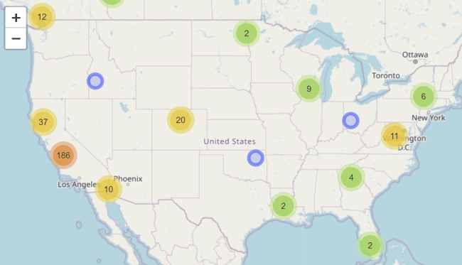
We had no idea how many people would sign-up, so I wanted to create a HTML summary of registered participants for our instructors and planning team to stay abreast of registrations as they trickled in. I knew we'd get people from all over, so I wanted the summary to have an interactive map showing participants' locations, as well as various summaries about their organizations and titles. I also knew that I would have to update this summary on almost a daily basis, so I needed the summary to be generated as automated as possible. There was no getting around having to manually download an Excel file, but my goal for everything after that was to do it "at the click of a button".

Geocoding. We didn't ask people on the registration form to enter their longitude–latitude coordinates, which meant I had to invoke a geocoding engine. However, I didn't want to geocode a participant more than once, both because it costs ‘credits' and takes a couple of seconds. I also needed a way to ‘help' the geocoding engine when the participants location info was incomplete (e.g., the name of a university, but not the city or zip code).

A small but significant number of cases could not be handled by either of the above approaches. Either the registrant omitted multiple locations fields, or my code didn't parse an international address correctly. These cases were flagged and saved in yet another CSV file. After each render, my script reported the number of unsuccessful location matches, telling me I needed to go look at the CSV file and if possible enter an ad-hoc geocoding string based on other information in the record. This worked in nearly all cases.


Generating the tabular summaries of registrants by domain type and organization was relatively straightforward using Regex expressions to parse those fields. The ‘title' field was very eclectic, as you'd expect, nevertheless some interesting patterns started to emerge that I wanted to capture. Manually putting titles into different categories is normally what I'd do, but registration was happening too fast so I needed a more automated solution. I decided to use a word cloud. I had never generated word clouds in R before, but after a few hours of reading forum posts and playing with packages, I settled on the wordcloud2 package with text cleaning functions from the tm (text mining) package. A nice thing about wordcloud2 is that the output is interactive (hover over a word to the effect), and every time you refresh the page it redraws the word cloud with a different color palette. Thank you to the amazing community of open source programmers who over many years have developed word cloud, leaflet, and all the other amazing open source plugins for the web!

Reflections and Lessons Learned
My homemade event technology solutions for DroneCamp using open-source software performed extremely well, with surprisingly few problems. In the process I learned a tremendous amount about integrating Google Apps, R, and Zoom that I will be able to draw upon for future work. Cracking the OAuth authentication dance and Google Apps sidebars were perhaps the biggest breakthroughs, which now gives me a way to automate tasks involving any of the dozens of web API services out there, including Google Apps, Zoom, DropBox, Slack, and many, many others.
I'm very cognizant of the fact that I'm the beneficiary of an enormously well-developed ecosystem of open-source tools. The ability to import and munge data with just a few lines of code, and present it in compelling HTML based widgets like leaflet and word clouds, is simply remarkable. I and everyone who benefits from my work stand on the shoulders of the legions of open source developers who have toiled for years and years to build and share these remarkable tools. Next time you encounter a popup window inviting you to send a small donation to support an open-source platform or buy a coffee for a developer, please consider this!
There are also a few things I would do differently next time, or advice I would give those with similar requirements. Some of the main ones include:
The value of a LMS. Many of the tools I was forced to build from scratch are features you would find in a Learning Management System (LMS). Perhaps the most valuable feature that would have been really nice to have is a one-stop-shop dashboard for participants. Most LMS's require users to create accounts, which by itself would have resolved a host of challenges regarding multiple emails, cross-checking registration status, distributing Zoom links to only those who need them, etc. LMS's also facilitate sharing course materials like slides and exercises, and give you more options to manage access.
Zoom User Accounts. If we were going to use Zoom again, I would definitely turn on user authentication. This simply means participants need individual Zoom accounts (free is fine), and use the Zoom app to join meetings and webinars. User authentication simplifies managing Zoom links, because upcoming Webinars and Meetings appear in the app. It also simplifies sharing recordings, and gives you better analytics. We initially discussed user authentication but shied away from it so as to not put further demands on participants. That was well-intentioned, but in hindsight there would have been more advantages than disadvantages for both participants and organizers.
Alternative Registration Systems. Linking Zoom meeting to a payment system doesn't just incur credit card fees, it also comes with workflow costs. Either you develop ad-hoc tools and protocols (as we did) to cross-check Zoom and event registration, or you adopt a 3rd party registration system like Evenbrite that integrates both payment and Zoom registration. All of these options come with tradeoffs that need to be incorporated into planning and support efforts.
Simpler, smaller, and/or free trainings can be conducted quite satisfactorily using just Zoom Meetings, but it helps to have a good understanding of Zoom's myriad of settings. Zoom's built-in registration system is actually quite configurable, something we didn't take advantage of. You can add your own questions and branding elements to the registration form. For trainings that only involve one or two meetings, that might suffice.

