You may have heard some buzz lately about a possible "Super El Niño" on the way. It's been getting attention in the news. If you're a gardener in the Eastern Sierra, super probably got your attention, given our past mild winter and warm Fall. El Niño conditions often mean more precipitation, which is usually welcome here in the West.
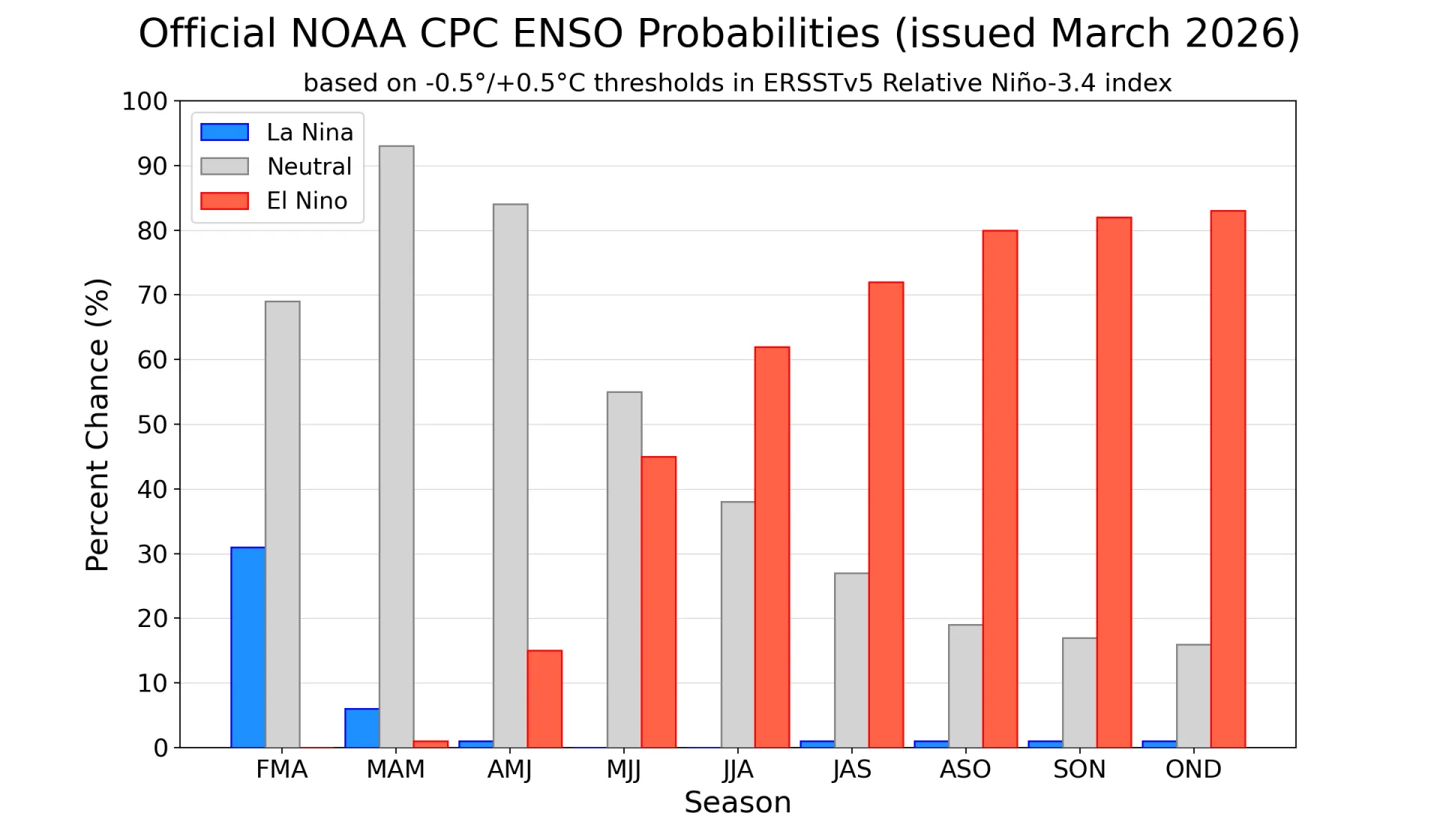
Right now (April 6, 2026) according to NOAA, we’re still technically in a La Niña pattern. That's the phase that tends to steer storms away from the Southwest and leave us on the dry side. But it's weakening, and there's about a 60% chance we transition into El Niño by this summer. In other words, the southern Pacific Ocean is shifting gears, and that shift can influence where storms go later this year.
This whole system is called the El Niño–Southern Oscillation (ENSO). At its simplest, it's a pattern of ocean temperatures in the Pacific that affects weather patterns around the world. When ocean waters are cooler than average (La Niña), we tend to get drier winters in the Southwest USA. When they're warmer (El Niño), the Jet Stream often dips farther south, which can bring more storms and more moisture into California.
For gardeners the key detail is timing. Even if El Niño develops this summer, we won't really feel its effects until winter when storm tracks shift and precipitation patterns change. A well-developed El Niño often increases the chances of a wetter winter, which can mean better soil moisture, improved snowpack, and a stronger start to the following growing season. But it isn't a guarantee: some El Niño years underperform, and local conditions always matter.
If you like looking at colorful weather charts, as of writing this post here is the most current ENSO update from NOAA. (PDF File from NOAA.)
About that phrase Super El Niño that's popping up in the news cycle: it is not an official scientific term as far as I can tell, and I'm always a little skeptical of reports with superlative language. Climate scientists describe these events as weak, moderate, or strong based on how much ocean temperatures deviate from what's considered normal. Super is just a media-friendly (attention-getting?) way of saying very strong. Some early signals suggest this could become a stronger event, but it's too early to say with confidence.
It appears we are moving away from a pattern that favors dryness and toward one that could support more winter moisture in the Southwest. The next few months should give us a clearer picture of how strong that signal becomes.
Summary
- Even with words like "Super" in the news, don't expect immediate changes this spring
- Keep planning for current conditions to continue
- Watch forecasts heading into Fall
- If El Niño strengthens, be ready for a potentially wetter winter