
- Author: Shane T Feirer
The third day of the ESRI User Conference was an exhilarating deep dive into the world of Artificial Intelligence. The AI Summit, the first of its kind hosted by ESRI, focused on the integration of AI into the ESRI ArcGIS Suite of software and tools. The excitement in the air was palpable as attendees explored the transformative potential of AI in GIS.
AI Summit Highlights
The AI Summit highlighted the strategic incorporation of AI into two broad categories within the ArcGIS ecosystem: GeoAI and AI Assistants.
- GeoAI: This category encompasses advanced AI models and algorithms specifically designed forgeospatial analysis. Attendees learned about howGeoAI can enhance spatial data interpretation, improve predictive modeling, and support more accurate decision-making. The sessions showcased real-world applications, demonstrating howGeoAI is being used to tackle complex challenges. These tools included:
- Deep Learning Models and object detection and pixel classification
- Unstructured text searching and geocoding
- and many others
- AI Assistants: These tools are designed to augment the user experience within theArcGIS platform, making it more intuitive and efficient. AI Assistants leverage generative AI to provide intelligent recommendations, automate routine tasks, and enhance data visualization. The demonstrations highlighted how these assistants can streamlineworkflows, improve productivity, and empower users to extract deeper insights from their data. AI assistants are being included in:
- Help documentation, online and within ArcGIS Pro
- Webmapping - Smart mapping
- Survey 123 webform design
- ArcGIS AI Hub Assistant
- and the list goes on
Innovative Applications and Future Directions
Throughout the day, experts and innovators shared their experiences and insights on the cutting-edge applications of AI in GIS. From machine learning models that classify historic and current aerial photos to AI-driven tools that optimize road condition extraction from full motion video capture, the presentations underscored the vast potential of AI to revolutionize the field.
Exciting Outcomes
One significant outcome of the day was my decision to request access to ArcGIS Hub Premium and its AI Assistant. This powerful tool will enable the querying of geospatial data created and maintained by IGIS and UCANR using AI using a natural language model. This will open up major opportunities for those needing information about UCANR and data that is important to Californians, making it easier to access, analyze, and leverage critical geospatial information.
Looking Ahead
The integration of AI into the ArcGIS Suite represents a significant leap forward, promising to unlock new possibilities for geospatial analysis and decision-making. As the conference progresses, attendees are eager to see how these advancements will continue to evolve and shape the future of GIS.
Perspective on AI
In response to concerns that AI might replace GIS professionals, the panelists provided some important perspectives. They emphasized that GIS professionals may potentially lose their jobs if they don't embrace AI. Just like if a GIS Professional was still using AML or Avenue programming laguages instead of modern languages and tools, they would eventually be replaced by someone who was using new languages and tools. The was reinforced a comment by one panelist who added, "If you lose your job because of AI, it will be to someone who is using AI."
Stay tuned for more updates and insights from the 2024 ESRI User Conference! The journey into the future of GIS, powered by AI, has just begun.
- Author: Priyanka Dhirenbhai Vyas
Where is the nearest oak tree close to 1600 Pennsylvania Avenue NW, Washington? How many trees are in Washington DC? When is the trash pick-up date for 1600 Pennsylvania Avenue NW? These are some of the questions that residents can answer using AI feature in the Open Data Portal.
ESRI's team along with its partners is testing models through which AI can be trained to search through and query data sets within the data portals of state and local government as well as within ArcGIS Hubs.
To ensure data are easy to discover, share, and can be reproduced, ESRI devoted a session on ensuring users are maintaining metadata and preparing it in a way it is ready for AI. How to ensure that AI assistance search is limited to data within the hub is something ESRI is still working on.
ESRI is working on a suite of tools to increase collaboration among teams and within community. One such feature is the Discussion Board in ArcGIS Hub. For example, when a small team working for the parks and recreation has to decide some good spots to set up picnic tables, a user can invite other members in the team to share their comments. Along similar lines, ESRI also gave considerable attention to its product Pipeline. Similar to Model Builder which works in ArcGIS Pro, Pipeline connects datasets and workflows in ArcGIS Online. ESRI's collaborative tools are also aimed at including users and databases that are not spatial in nature such as Knowledge Graphs. Knowledge graphs harness the knowledge of graph theory to bring connections between people and places and what happens when one of the nodes in the chain gets affected by an externality. Clearly, with products like knowledge graph ESRI is reaching new territories as it brings people who are working with non-spatial data also into using ArcGIS products.
ESRI's partnership with Microsoft remained in the spotlight with sessions focused on Introduction to Microsoft Fabric, ArcGIS tools available in Office 365 with Excel, SharePoint, Power BI, and Teams.
After a series of technical sessions, the crowd was eagerly waiting to watch John Nelson's and Kenneth Field's session on Map Wizardry. Even 45 minutes before the session started, participants had already started queuing up outside the ballroom. With over 500 participants, this probably was the most attended session after the plenary. Both Kenneth and John kept the audience entertained and engaged with their cutting-edge techniques on 2D cartography while Nathan Shephard amazed the crowd with his 3D maps.
With several technical sessions and user presentations, ESRI continues to keep the voracious appetite of the conference attendees to come back for Day 3 of the conference.

- Author: Shane T Feirer
The first day of the 2024 ESRI User Conference was filled with exciting announcements and innovative stories of Conservation and GIS. With around 21,000 attendees in San Diego and an additional people joining virtually, the energy and enthusiasm were palpable.
Plenary
Jack Dangermond and the ESRI team highlighted several new offerings in their plenary session. Notably, they introduced new datasets in the ArcGIS Living Atlas, including a national tile service of parcel boundaries and a feature layer of iNaturalist species observation data. These additions promise to provide users with even more comprehensive and valuable data for their projects.
The Governor of Minnesota, Tim Walz, a former high school Geography teacher, delivered an impassioned plenary speech on the importance of GIS in solving the challenges we face today. He emphasized the critical need for maps, data, and the work that GIS professionals do to address global issues.
New Apps and Features
ESRI also showcased a range of new apps in ArcGIS Online:
- Portfolio App: Designed to help users highlight key maps of interest, making it easier to share important insights with others.
- Web Editor App: This app offers a web-based editing experience similar to editing in ArcGIS Pro, making it more accessible for users to update and manage their data.
- Generative AI in AI Assistants: The inclusion of generative AI enhances the capabilities of spatial analysis, providing users with more intelligent and responsive tools and apps.
Additionally, several new story map templates were introduced, adding more options for users to create compelling narratives with their data.
Looking Ahead
With so many exciting developments on the first day, attendees can look forward to even more innovations and detailed sessions over the next three days. The future of GIS is looking bright, and the tools and features unveiled at this conference are set to drive the industry forward.
Stay tuned for more updates and insights from the 2024 ESRI User Conference in the coming days!
- Author: Priyanka Vyas
- Editor: Andy Lyons
- Editor: Sean D Hogan
- Editor: Genoa Starrs
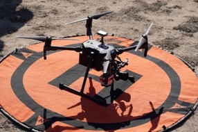
We bring you stories from DroneCamp 2024, now in its 8th year and wrapping up a successful week at CSU Monterey Bay.

“The goals of a prescribed burn are to reduce fuel load as much as you can, improve habitat and work with private landowners. I am especially excited to learn about drones equipped with thermal cameras to study fuel moisture and study ignition pattern of fires”, she said. Barb is hoping to learn object detection methods that can be used to process the imagery collected from drones and facilitate prescribed burns.
Hosted at California State University Monterey Bay Campus, this year's DroneCamp, now in its eighth year, leveraged upon the combined expertise of several UCs, CSU, and community colleges. It pooled together 29 instructors from CSU Monterey Bay, UC ANR, UC Merced, UC Santa Cruz, UC Berkeley, UC Los Angeles, Lakeland Community College, and American River College. The instructors bring deep expertise in drone hardware, flying, and processing imagery collected through drones.

80 participants , mostly from California , attend the in-person event in Montery, with another 43 participants who attended virtually. While the virtual participants get access to almost all the sessions that in-person participants get, they miss the most exciting part --- which is learning to fly drones.

“After attending the DroneCamp, I can help farmers collect and report their data better to the funders. I am excited to work with farmers to assess changes in biomass production over time to see how well the plants grew after the grant. We can also take pictures of the field to see whether all the plants are getting uniform water. Depending on where the plants are in relation to the pumps, some may get too much or too little water. We can use drones to see whether the irrigation system is uniform.”
Another application Ana is interested in is assessing the effectiveness of cover crops on farmland. Cover crops are crops planted between cash crops that provide various benefits and keep the land from being fallow. “We can use drones to compare different cover crops and how they perform to control weeds in fields”.
When asked how confident Ana feels about undertaking projects independently using drones in her work, she said, “DroneCamp gave me the connections I need to reach out to experts when I work on my own project”.

After attending DroneCamp, he feels he has attained basic skills and knowledge needed to fly a drone over an orchard, and ideas on how to use drone data to assess crop response to irrigation in a field.”
Tobias says, although satellite-based remote sensing is currently used to estimate how much water is by used by crops, there are still some questions regarding their accuracy. These are questions that researchers in the field are working on answering.
He notes: “Considering drones work on a field scale, it could help potentially refine the accuracy that we do not get from other remote sensing platforms.
DroneCamp also drew students from various universities who have taken some GIS training at their academic institutions, but not in mapping with drones. Manjot Singh, a student in plant science and agriculture from Fresno State University says, “I can get introductory and advanced GIS courses at my university, but there is no drone related course being offered”. May be this will help me if I pursue a PhD or make me marketable in future jobs”.
- Author: Andrew J Lyons
- Contact: Sean D Hogan

June 24-28, 2024
CSU Monterey Bay
(plus virtual open)
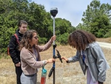
DroneCamp is a premiere five-day training program that covers everything you need to know to use drones for mapping and data collection.
Curriculum at a Glance
- equipment
- safety & regulations
- flight planning
- manual & autonomous flight
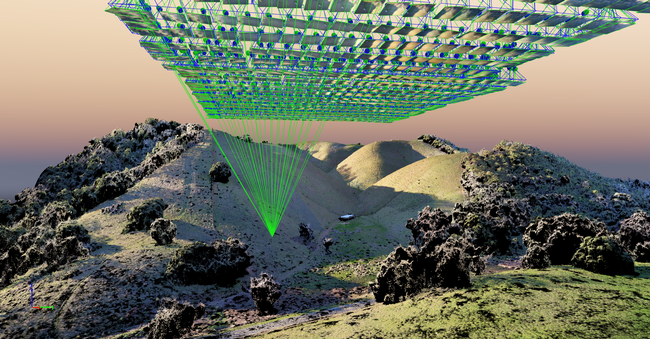
- photogrammetry
- hands-on data processing with Pix4D, OpenDroneMap & ArcGIS Pro
- data analysis & visualization
- research talks & use cases
- educator track - new for 2024!
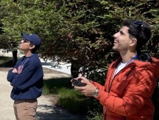
Now in its eighth year, Drone Camp 2024 will once again provide a unique drone training opportunity designed for a wide range of skill levels and interests, from complete beginners with little to no experience in drone technology, to intermediate users who want to learn more advanced data processing and analysis.
DroneCamp started out as an IGIS workshop, but has evolved into a highly collaborative program with instructors coming from 8 campuses including UC ANR, UC Merced, UC Santa Cruz, CSU Monterey Bay, UC Davis, UC Berkeley, UC Santa Barbara, Lakeland College, and American River College.
DroneCamp 2024 will be held in-person at CSU Monterey Bay June 24-28, 2024. Scholarships to cover the registration fee are available for all ANR academics and staff - but you must apply soon! More info available at DroneCampCA.org.
 |
 |
 |
 |

