- Author: Sean D Hogan
- Author: Steven Worker
IGIS is proud to announce its collaboration with 4H on a new and exciting, three-year, USDA-funded grant, Ag from Above x Ag for All (AFA2), aimed at sparking interest in food and agriculture among teenagers by using cutting-edge drone and mapping technologies. By blending hands-on activities with real-world applications, AFA2 empowers young people to explore the science behind agriculture in fun and meaningful ways. AFA2 is not just about teaching technology—it's about using that technology to make a real difference in communities and ensuring that the next generation of agricultural scientists and leaders is diverse, skilled, and ready to take on the challenges of the future.
Period: 3-years from August 1, 2024 to July 31, 2027.
Tasks: Develop, test, and evaluate two curricula, SkyMappers: Agricultural Drones and GIS Mastery, Dronovation: Cultivating Change with Teens, and prepare an educator professional development guide.
Who It's For: This project targets teenagers aged 13 to 18, with special attention to including girls and Latino youth—groups often underrepresented in STEM fields.
Why It Matters: The future of farming and food production will increasingly rely on technology. By engaging young people with drones and GIS, AFA2 aims to build their scientific literacy and interest in agriculture, while also preparing them for future careers in these vital fields. Additionally, by focusing on food justice and culturally relevant learning, we aim to empower all young people to see themselves as future leaders in science and agriculture.
Our Partners: University of California's Cooperative Extension, 4-H Youth Development Program, Informatics and GIS Program, the UC Santa Cruz CITRIS Initiative for Drone Education and Research, and the UC Davis AI Institute for Next Generation Food Systems.
- PI: Steven Worker, 4-H Youth Development Advisor (Sonoma)
- Co-PI: Nathaniel Caeton, 4-H Youth Development Advisor (Shasta)
- Co-PI: Matthew Rodriguez, 4-H Youth Development Advisor (Placer)
- Co-PI: Andy Lyons, IGIS Program Coordinator (UC Berkeley)
- Co-PI: Sean Hogan, IGIS Academic Coordinator (Davis)
- Collaborator: Flavie Audoin, Rangeland Management Extension Specialist (Univ. of Arizona)
- Collaborator: Lucy Diekmann, Urban Agriculture/Food System Advisor (Santa Clara)
- Collaborator: Becca Fenwick, Director, CITRIS Initiative for Drone Education and Research (UCSC)
- Author: Sean Hogan
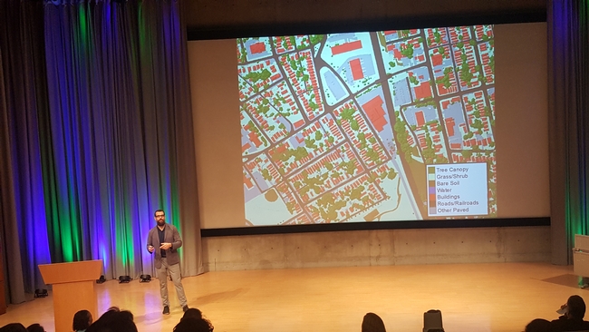
ESRI held its first ‘Imagery Education Summit' in Redlands California this week, and even though I came with high expectations, I was still pleasantly surprised with the caliber of the summit's presentations. It is very difficult to pick out a favorite among these talks; however, I can say that I particularly enjoyed the presentations by Jarlath O'Neil Dunn from the University of Vermont (pictured below), on ‘Success Stories and Progress' in image analysis and mapping, and by Jason Ur from Harvard University, regarding his work with ‘Drones and Archaeology Case Studies' in Iraq. The innovative approaches that they and others at the summit presented were truly inspiring!
One take-away from this event is that ESRI is making huge strides to incorporate more remote sensing processing options into ArcGIS Pro's ‘Image Analysis' toolbox. Speaking for myself, as both a remote sensing and GIS practitioner, I am excited about the prospect of being able to do more of my work within just one application environment, as opposed to doing my image stitching in Pix4D, image analysis in ENVI, and then finally my spatial analysis and mapping in ArcGIS. For the sake of efficiency, I look very forward to the day that I can do all of this in just one app.
For you drone enthusiasts out there, one neat new feature in the ArcGIS Pro Image Analysis tools is basic image stitching for producing color balanced orthomosaics and digital surface model outputs. This new function is not at the level of what Pix4D or Drone-to-Map can do yet, but for basic RGB image processing it may be good enough for many people's needs. Plus, it is a brand new tool that is bound to improve over time.
A couple more neat news items that were mentioned at the summit include:
- ESRI now offers a FREE ‘Schools Mapping Software Bundle', which includes both fully functional ArcGIS Pro and ArcGIS Online licenses for every K-12 school worldwide. http://www.esri.com/industries/education/software-bundle#.
- ESRI also now offers free ‘Massive Open Online Courses' (MOOCs), which among other things include approximately 30 courses on working with imagery alone, http://www.esri.com/mooc/imagery.
The future for spatial science has never looked brighter!


