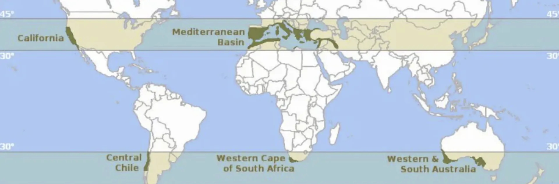
Have you ever wondered why you can't seem to grow beefsteak tomatoes in your Alameda City garden even though your friend in Livermore gets huge and wonderfully tasty ones? A big part of the answer relates to the different microclimates of each city. The University of California Agriculture and Natural Resources Division (UCANR) refers to microclimates as "small-scale, localized climates that differ from the surrounding larger climate." It turns out that Alameda County is a poster child example of microclimates that differ substantially from each other in terms of temperature, weather patterns and geography. In this Blog, we describe characteristics of the four main climate regions of the County and describe some causes for their differences, including those that may be relevant to the microclimate in your own garden. Overall, Alameda County boasts a climate similar to that found in the “Mediterranean” area of Europe, which is typified by both mild and generally wet winters and warm to hot dry summers. As shown in Figure 1, these types of climate represent only about 2% of land on earth.
Common methods used to describe regional climates
At the most general level, there are two main resources most often used to describe climate planting zones: the United States Department of Agriculture (USDA) Plant Hardiness zone map. and the Sunset Western Garden Book zones. Of the two, the Sunset zones provide greater detail than the USDA zones because they take into account additional characteristics.
USDA zones
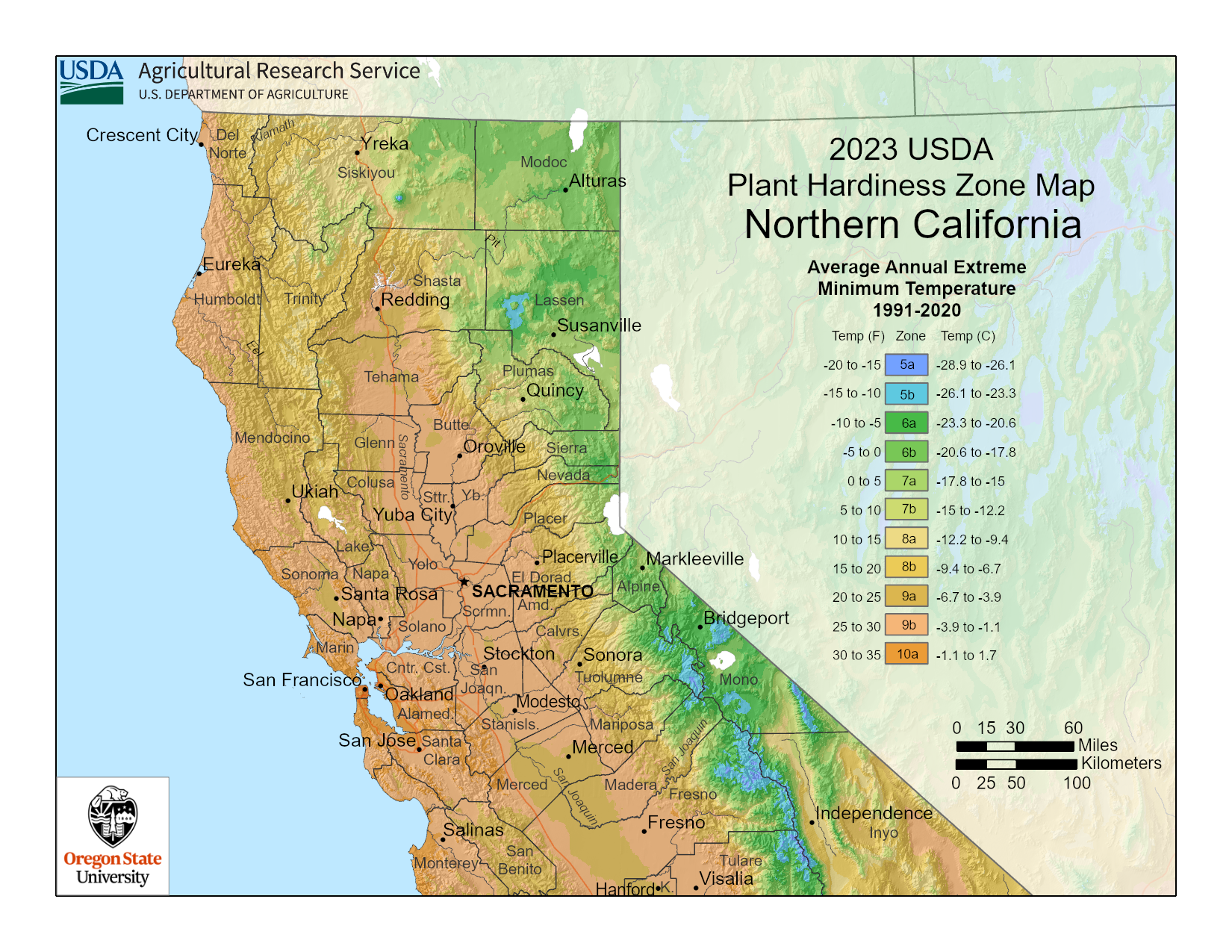
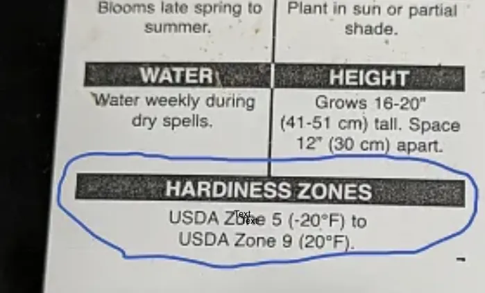
The USDA zone maps (updated 2023) report the average annual minimum temperature in 10 ° F increments for 13 North American zones, including a map for Northern California. These zones can be subdivided in 5° increments labeled “a, b, c..”. The site hosts a lookup tool enabling users to find their zone by zipcode. For Alameda County, the urban areas nearest to the coast, including the cities of Alameda, Berkeley, and some areas of Oakland, are in subzones 10a and 10b. The inland areas of the County are in zones 9a and 9b, and experience colder winters than the more coastal zones. While the additional information offered by the Sunset zones can be especially useful for gardeners, the older and more established USDA scale is most often reported by growers and nurseries. Figure 2 provides an example.
Sunset Western Garden Book zones
Compared to the USDA zones, the Sunset zones (updated 2012), offers a different type of information than that from the USDA. It also provides greater precision in describing climate characteristics as each of its 24 North American zones as it takes into account such features as marine influence, summer heat and elevation. The site provides a general description of the zone’s features accompanied by a list of plants that are likely to do well in it. A color image and detailed characteristics of each plant, planting instructions and recommendations for its care are also provided. Alameda County is in the San Francisco Bay and Inland zone. Note that Sunset describes as “zones” both the San Francisco Bay and Inland region and the four main regions within it as zones. In this Blog, we designate these four regions as “sub-zones” to clarify these relationships.
Because of their significant differences,the Sunset sub-zones described below can be thought of as regional microclimates
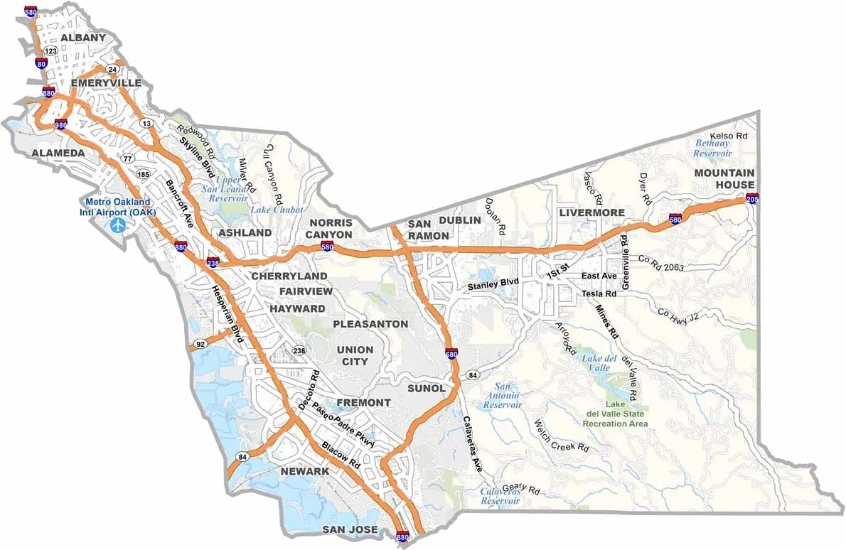
- Sub-Zone 17 (Marine Effects). This sub-zone covers the immediate coastal strip, including Oakland, Berkeley, the city of Alameda and San Leandro. It is characterized by cool, foggy summers and mild winters, dominated by coastal weather. The western edge of the County borders on the San Francisco Bay (colored blue). This coastal region, together with inland water bodies (also colored blue on the map), result in relatively mild temperatures near those areas.
- Sub-Zone 16 (Central & Northern California Coast Thermal Belts). Thermal belts are found on slopes and hillsides of the coast range and exhibit warmer temperatures than the immediate coastal, fog-prone sub-zones. Found on slopes and hillsides of the coast range, they include portions of Oakland and Berkeley from which cold air drains. This sub-zone gets more summer heat than Sub-Zone 17 but remains dominated by ocean air. The better air drainage of these thermal belts make them warmer in winter than the valley floors.
- Sub-Zone 15 (Chilly Winters along the Coast Range): This sub-zone experiences colder winters than the coastal thermal belts (Sub-Zone 16) but is still influenced by the Coastal Range. Its inland valleys still get some marine air in parts of Castro Valley and Hayward.
- Sub-Zone 14 (Northern California inland with ocean Influence). This sub-zone applies to inland areas like Pleasanton, Dublin and Livermore, which are hotter than the more coastal areas. They exhibit both much hotter summers and colder winter nights.
Features associated with different microclimates
Many features lead to the differences in the regional microclimates for the sub-zones described above. (Adapted from “Understanding Your Planting Zone and Microclimates”) Topography is one of the main ones.
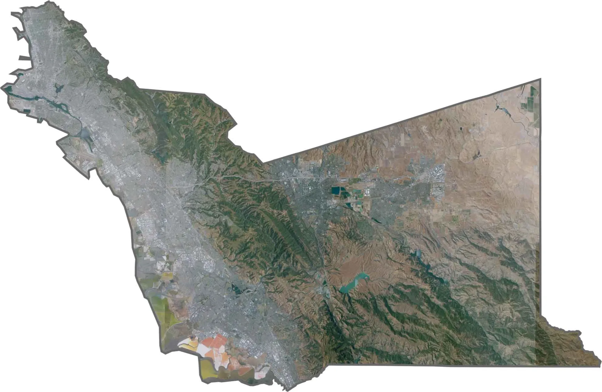
- Topography. The general nature of the land in a particular microclimate has a major impact on temperature and precipitation. Alameda County includes cool valleys that result in relatively cool microclimates but also hilltops that are exposed to wind and fluctuating temperatures. Figure 4 shows the same map as shown in Figure 3 but was taken by satellite to capture the main topographic features of the County. Note the significant regions of higher terrain across the map that highlights the hilly areas that punctuate the map and lead to differences in climatic characteristics.
Additional causes of microclimates include:
- Influence of water bodies. The western edge of the County borders on the San Francisco Bay (as shown in Figure 2) and inland water bodies (colored blue on that map) that together result in relatively mild temperatures near those areas.
- Urban islands. Concrete and asphalt in the larger urban areas near the coast retain heat. The largest area of this feature can be seen on the bottom center of this map.
- Trees, vegetation, and open grassland. Trees and dense vegetation cool the air, leading to microclimates with relatively high humidity. Substantial regions of open grassland can lead to variable temperature fluctuations as well.
Other characteristics of microclimates
- Temperature. Compared to the regional climate zones, microclimates can be warmer when exposed to steady sunlight and where wind exposure is low. They can be cooler in areas of local high elevation and shade.
- Wind. Buildings, hills or other obstacles can alter wind patterns that result in unique local microclimates. Depending on whether they face the wind or are protected from it, the prevailing winds may be stronger and faster, or sheltered, leading to complex fluctuations in both temperature and humidity.
- Precipitation. Mountains can block the normal movement of precipitation, resulting in drier microclimates on the protected side. This can occur where rain clouds drop their moisture on the side that faces the wind but fail to climb high enough to drop their precipitation on the other side. Although not in Alameda County, this occurs in the Sierra Nevada mountains of central California where precipitation in the form of snow or rain can be heavy on the western face of the mountains but drops less precipitation on the eastern side, resulting in a drier climate on that side.
Microclimates in your garden
Although it's relatively easy to identify your microclimate region from the Sunset zones, the definitions they provide are general and won't take into account the much more complex characteristics that apply in the microclimates of your own garden or landscape. If you've lived with your garden for a while, you already know that shade trees and overhead structures are the place to grow your shade-loving plants. For the remainder of the garden, it turns out that knowing how much sun exposure you have relative to the placement of your house is an important key for successful garden design.
- South and west facing walls. These walls absorb solar energy during the day and release it as night time temperatures cool. These are good areas for planting vegetables that require full sun (6+ hours of direct sunlight). These areas may be too hot for plants such as snap peas that are better planted in the late winter or early spring.
- North walls receive much less direct sunlight so are better suited to shade-loving plants (3-6 hours of direct sunlight) including ferns.
- East walls usually get about half a day of sun (3-6 hours direct sunlight).
- Eaves can be shady and often represent a protective area for delicate plants such as tuberous begonias growing in pots placed under them or hanging from protected areas of the eaves.
- Slopes can have warmer air flow compared to hilltops or valleys. If in a shady area, they are good sites for citrus or other heat-sensitive plants.
To accommodate the many characteristics of your garden microclimates, watering your plants in a way that takes into account their various needs may be best achieved using a drip system that allows detailed tailoring for each area's temperature and sunlight requirements.
Climate change and native plants
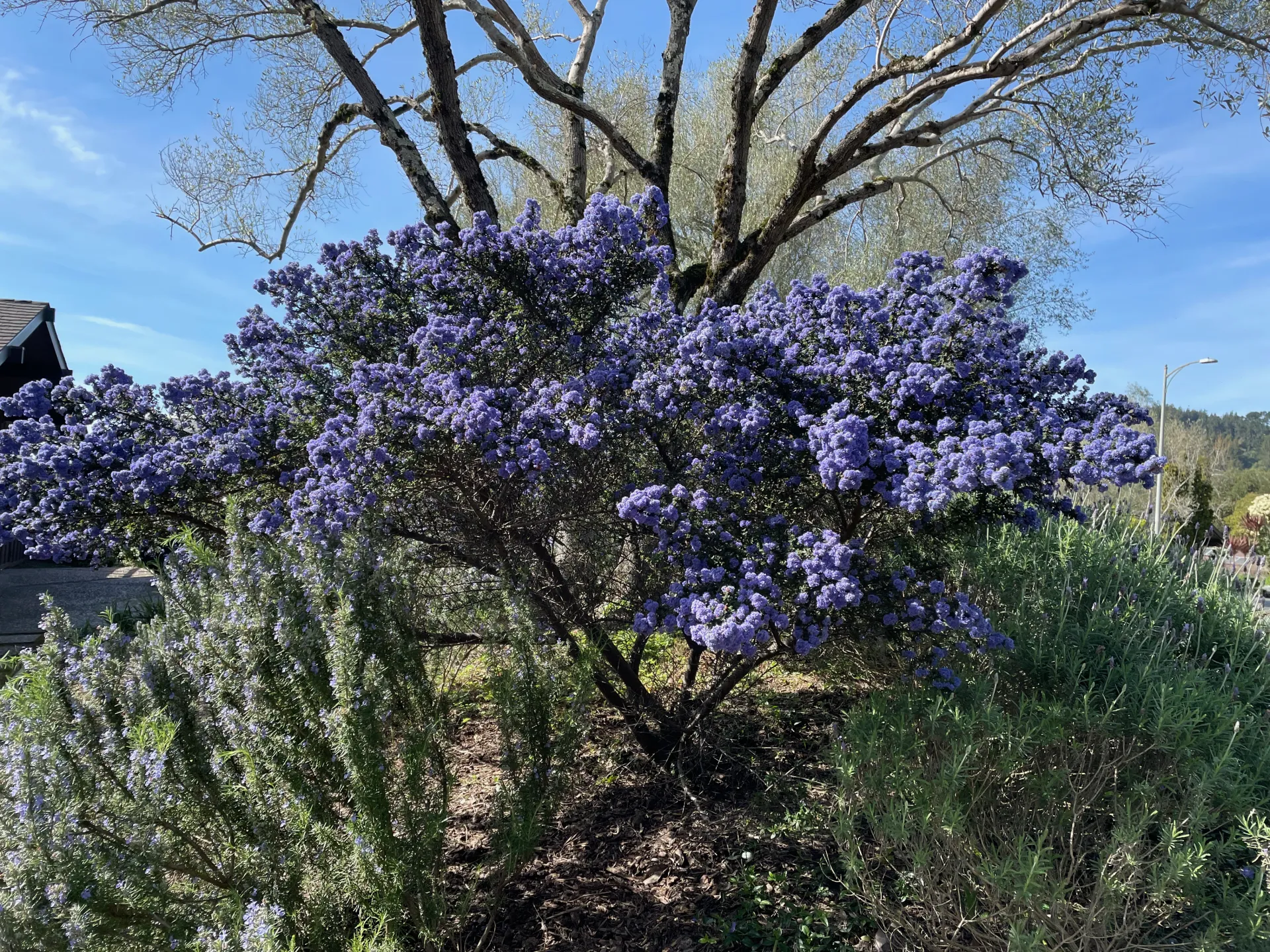
However carefully you design your landscape to accommodate its microclimates, your garden plan will likely be challenged by changing conditions that are hard to predict. Increasing incidents of drought and heat waves can upend your expectations for getting a bounteous vegetable or floral harvest in any one season. One way to mitigate the impact of both drought and heat waves in your own garden is to include some native plants in your garden design. Native plants have co-evolved over thousands of years to flourish in our microclimates and contribute to our wildlife ecosystem. (See the Calscape Native Plant Society for their catalog of 8,500 native plants. This collection is accessible through a rich and searchable resource for information about obtaining and cultivating these special species.) Figure 4 shows an example of blooming Ceanothus, growing on a slope. Calscape notes that this genus is highly drought-adapted and should not be watered, as excess moisture can shorten its lifespan.
Summary
Alameda County is an excellent example of a Mediterranean type climate containing four regional microclimates that differ substantially in their general features. For example, the County boasts areas where heat-loving plants flourish while others are foggy and cooler through the summer. Drilling down to identify specific characteristics within each region reveals some of the causes for these differences. This Blog also reviews detailed features that can lead to variations even within individual gardens. Gaining a better understanding of the microclimates of your own garden is an important step toward optimizing your gardening success.
References and resources
The University of California Agriculture and Natural Resources Division has many articles about Alameda County microclimates. Two of the most pertinent to this Blog are listed below.
Gardening in a Mediterranean Climate Zone. from the UC Master Gardener Program of Contra Costa County. The image in Figure 1 is taken from this article.
Understanding Your Planting Zone and Microclimates. from UCANR Garden Notes. This article gives an introduction about climate zones and the Mediterranean-like climate along with details about causes and characteristics of microclimates. It also lays out detailed information about how to identify and manage specific features of microclimates within an individual garden or landscape.
Other resources
USDA Plant Hardiness zone map and the hardiness zone map for Northern California.
Sunset Western Garden Zones and the map for the San Francisco Bay and Inland zone in which Alameda County is located.
Alameda County Map. (2026). https://uscountymaps.com/alameda-county-map-california/ Map shown in Figure 3, used with permission.
The California Native Plant Society (Calscape) is “California's hub for native plants and native plants gardening.” It can be reached at https://calscape.org
Want to learn more?
This blog post is brought to you by the Help Desk of the UC Master Gardeners of Alameda County. Subscribe to our blog!
Have a Gardening Question? We'll Help.
Visit our Help Desk page to submit your question and see additional ways you can reach us.