By Annette Wyrick, UC Master Gardener of Placer County
From The Curious Gardener, Summer 2021
During the past year, we have been at home more and this has given us an opportunity to look at and use our gardens throughout the seasons. While the garden has become a way to expand living space, it may not be living up to your expectations. You may have a small area that needs a new planting design or you have thought about a complete redesign of your entire yard. Summer is a great time to prepare for a design by taking a site inventory and analyzing existing conditions for problems or potential.
The first phase is to gather basic information about your site. A plat, a map of your residence and property lines, may be obtained from your county’s surveying and mapping department. The county will have information on setbacks, easements and rights-of-way on your property. If you live within a HOA, obtain information on landscape covenants.
Continuing to gather information, you will take photos and measurements of your site. Shooting “before” photos of your home’s exterior walls and existing hardscape will be a helpful reminder of the materials and patterns already existing in your garden. Taking photos from each window or door into the garden will show you the primary views. Maybe you will find views you can borrow beyond your property line.
After taking photos, it is a good time to draw a sketch of your property. Start with a bird’s eye view of your residence and property lines. Record measurements for these first. Depending on how large and detailed your landscape is, you may need to sketch sections on separate sheets of paper. Sketch other structures (sheds, garage, etc.), existing hardscape (paths, patios, pools, etc.), utilities (septic/leach zone, propane, power lines, water meter, etc.), and plants.
Next is measuring the existing elements of your site. Start by checking the location of your residence in relation to the property lines. Sometimes the actual build differs from the plat. The corners of the property are usually indicated with a stake in the ground, mark in concrete, or other similar indications. If you are uncertain where the property lines are, seek the help of a surveyor.
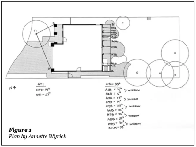
The two most common types of measurements are baseline and triangulation. Baseline measurements are running measurements between two fixed points. An example of where you would use this is along a wall or a fence. Triangulation measurements are used to locate one unknown point from two fixed or reference points. These are very useful in determining tree locations and curvilinear hardscape designs. See Figure 1 (previous page) for an example of baseline and triangulation measurements. For more detailed information on measurement methods, visit https://edis.ifas.ufl.edu/publication/EP427.
Other useful data to collect is the distance from ground level to the bottom of windows, plant names and diameters, tree trunk diameter, canopy radius, height to canopy, root zone conditions, structural and hardscape materials and heights from ground level, and architectural style of home.
Now you are ready to sit down and draw a scaled base map from your measurements. A scaled base map is important in determining space available for hardscape and plant areas. There are many applications available to create digital plans, but there is generally a learning curve to use them. Traditionally, drawings are on 24" x 36" paper. Use your sketch and measurements to create your scaled drawing. Label your drawing, write down the scale used, and indicate the north direction.
EXTERNAL IMAGE
While taking measurements in the garden, you will have already begun the process of site analysis. The purpose of analysis is to determine what is a problem or has potential. Problem areas can be corrected in the new design and areas with potential can be further developed. The following should be analyzed: soil, drainage, sun/shade patterns, wind direction, plants, views, sounds, and smells. Soil samples should be collected and sent for analysis. When it is time to create a planting plan, select appropriate plants for the type of soil you have. Plants may give clues to soil conditions such as poor drainage. Proper drainage is very important in the landscape. Water should move away from structures and be directed to other areas for percolation into the soil. Sloped areas should be analyzed for degree of steepness, stability and water runoff. The north arrow on your map will be helpful as you think about how the sun and shade patterns change throughout the year. Microclimates, such as those created by reflected heat and light, or deep shade on the north side of structures, will influence activity areas and plant choices. While there may be a prevailing wind direction, it will be influenced by plants, structures, and open areas. Plants should be evaluated for health, function, and aesthetic purposes. Views, sounds, and smells will affect the placement of activity areas. To complete the site analysis, you need to create a design brief which lists everything you want to accomplish in your garden as well as the style. Think about activity spaces, circulation of people, views/ screening, and what needs to be added or removed.
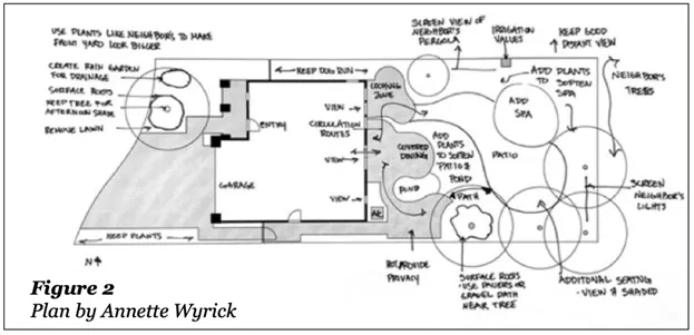
The next step is to make a copy of the base map and add site analysis notes to it. See Figure 2 for an example of site analysis.
Garden design is a process of taking a site inventory, analysis, and using design principles with creativity to create a space that fulfills the majority of your desires. Creating a base map and site analysis are the first steps of the process.
These first steps will prepare you to make decisions and get the creativity flowing for the next part of the design process.
References/Resources
- Hansen, Gail and Erin Alvarez. Landscape Design: Putting Your Yard on Paper- Site Measurements and Base Maps. University of Florida, Environmental Horticulture. May 8, 2019. https://edis.ifas.ufl.edu/publication/EP427